
Casa Conejo is an unincorporated county island in Newbury Park, Ventura County, California, United States. It was the first planned community in Newbury Park and began building in 1960. When the city of Thousand Oaks incorporated 4 years later, the new developments in Newbury Park were incorporated into the city boundaries before being subdivided. The community is bordered by Old Conejo Road and the US 101 to the North, Borchard Road to the South, Jenny Dr. to the West, and Sequoia Middle School to the East. For statistical purposes, the United States Census Bureau has defined Casa Conejo as a census-designated place (CDP). The census definition of the area may not precisely correspond to local understanding of the area with the same name. The population was 3,249 at the 2010 census, up from 3,180 at the 2000 census. Casa Conejo is located in a roughly rectangle-shaped unincorporated area surrounded by the city of Thousand Oaks.

The Conejo Valley is a region spanning both southeastern Ventura County and northwestern Los Angeles County in Southern California, United States. It is located in the northwestern part of the Greater Los Angeles Area.

Conejo Valley Botanic Garden is located in Thousand Oaks, California, and consists of a peak with vista views along with fifteen hillside botanical gardens. It lies next to Conejo Valley Community Garden and immediately across the street from Tarantula Hill, the highest point in Thousand Oaks. It provides a teaching laboratory for what flora works and what does not work in the Conejo Valley.

The Grant R. Brimhall Library serves as the main library for the city of Thousand Oaks, California. It is controlled by the Thousand Oaks Library System, which also controls the Newbury Park Branch Library. The Grant R. Brimhall Building is located on Janss Rd. near State Route 23. There are 81,000 square feet (7,500 m2) in the main building and 3,000 square feet (280 m2) in the adjacent Special Collections Storage building. It serves Thousand Oaks, including Newbury Park and Westlake Village. It is the largest library in Ventura County, the largest library in the region, and one of the largest in Southern California.

Santa Rosa Valley is a rural unincorporated community, named after the eponymous valley in which it lies, located in Ventura County, California, United States. For statistical purposes, the United States Census Bureau has defined Santa Rosa Valley as a census-designated place (CDP). The census definition of the area may not precisely correspond to local understanding of the area with the same name. The 2010 United States census reported Santa Rosa Valley's population was 3,334. Santa Rosa Valley sits at an elevation of 433 feet (132 m).

Rancho Conejo Playfields is a 13 acres (5.3 ha) multi-use community park in Newbury Park, California, adjacent to Conejo Canyons Open Space and the Arroyo Conejo Nature Preserve which includes 302 acres (122 ha) of public open-space land and numerous trails in the western Simi Hills.

Lynn Oaks Park is a seven-acre community park in the southern part of Newbury Park, CA, which includes trails to numerous surrounding nature areas, including but not limited to the Hope Nature Preserve, Hidden Valley, and the Santa Monica Mountains National Recreation Area. It was first developed as a community park in 1983 and is named for its many oak trees. The park contains a volleyball court, outdoor basketball court, soccer field, a playground, barbecue grills, water fountains and numerous picnic tables. Some of the trails include the shorter Spring Canyon Trail and Oak Creek Canyon Loop, while the Los Robles Trail connects Lynn Oaks Park to the Hope Nature Preserve and beyond to Hidden Valley and the Santa Monica Mountains National Recreation Area.
Satwiwa was a former Chumash village in the Santa Monica Mountains of Newbury Park, California. The current Satwiwa Native American Indian Culture Center is operated by the National Park Service in cooperation with the Friends of Satwiwa. Satwiwa has been inhabited by Chumash Indians for over 10,000 years. It is situated at the foothills of Boney Mountain, a sacred mountain for the Chumash.

Hill Canyon is a deep canyon in the western Simi Hills and within northern Newbury Park and Thousand Oaks, in Ventura County, southern California.

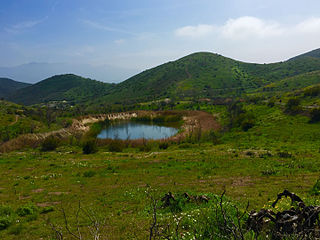
The Conejo Canyons Open Space consists of 1,628 acres (659 ha) of open-space areas in northernmost Newbury Park, Ventura County, California. It consists of deeply eroded canyons, numerous ridgelines and plateaus in the northwestern portion of the Conejo Valley. The area consists of diverse natural features such as deep canyons with perennial streams, prominent ridgelines, volcanic mountains, and a variety of natural habitats. While some of the flora includes chaparral, riparian habitats, oak woodlands and coastal sage, fauna includes mountain lions, coyotes, mule deer, and bobcats.
The Potrero Ridge Open Space is a passive recreation area in the southwestern portion of Newbury Park, CA and the Conejo Valley that encompasses eastern parts of the Potrero Ridge. The open-space area contains a total of 203 acres (82 ha), and is owned and operated by the Conejo Open Space Conservation Agency (COSCA). It is adjacent to the Dos Vientos Open Space in the west, which provides further access to the Santa Monica Mountains National Recreation Area by Satwiwa, as well as the Alta Vista Open Space, Los Vientos Open Space, and Los Robles Trail which leads to Los Robles Open Space in Thousand Oaks, CA and further into Westlake Village.

Deer Ridge Open Space is a 188-acre public-owned open-space area in the southwest portion of the town of Newbury Park, California. It contains a series of north-facing mountainous ridges and canyons, dominated by chaparral and oak trees. It shares borders with the Santa Monica Mountains National Recreation Area to the south, and the Los Robles Trail traverses the length of Deer Ridge Open Space. Its main trailhead is located on Potrero Road, while a smaller access point is located at the southern end of Felton Street. The Los Robles Trail is the Conejo Open Space Conservation Agency’s longest trail, and connects to open-space areas and parks such as the Los Padres Open Space, Conejo Ridge Open Space, Hope Nature Preserve, Old Conejo Open Space, and the Los Vientos Open Space. The trail in Newbury Park provides panoramic views of the Conejo Valley and Santa Monica Mountains, before entering the Hope Nature Preserve. The Los Robles Trail provides more than 25 miles of contiguous trails connecting Newbury Park to Westlake Village in Los Angeles County. Immediately south of the Deer Ridge Open Space in Newbury Park are the Hidden Valley and Rancho Sierra Vista Satwiwa.

Arroyo Conejo Nature Preserve is a nature preserve located in the western Simi Hills and within the Conejo Canyons Open Space, in northern Newbury Park, Ventura County, California.
Dos Vientos Open Space is a 1,216 acres (492 ha) open space area in western Newbury Park, California. It contains more than 41 miles (66 km) of trails used for cycling, hiking and equestrians. Originally a part of the Rancho Guadalasca Spanish Land Grant of 1836, the area is now an important wildlife movement corridor into the Santa Monica Mountains through the Point Mugu State Park. It provides a habitat for a variety of wildlife, including bobcats, mule deer, coyotes, eagles, hawks, barn owls, mountain lions, and more. It provides regional and internal trail connections, many trails offering panoramic views of the Conejo Valley, Oxnard Plain, Topatopa Mountains, Channel Islands, and the Pacific Ocean. Some of the endangered plant species found here include Conejo Buckwheat, Verity's liveforever, and Conejo Dudleya. The landscape is undeveloped, and dominated by coastal sage scrub, grassy hillsides, oak woodlands, and chaparral habitats.

Ventu Park Open Space is a 141-acre open space area in Newbury Park, California. Its primary features are the Rosewood Trail leading to Angel Vista, a 1,603 ft peak in the Santa Monica Mountains. Parking for the Rosewood Trail is located at the Stagecoach Inn Park, across Lynn Road from the primary trailhead. The Rosewood Trail begins with oak woodland and crosses a creek at the canyon floor, before climbing up towards the steep Angel Vista Point. There are 360-degree panoramic views of the Conejo Valley, the Oxnard Plain, the California Channel Islands, Pacific Ocean, Point Mugu, Hidden Valley, as well as the Santa Monica-, Santa Susana- and Topa Topa Mountains.

Mount Clef Ridge is a 1,076 ft volcanic mountain in Thousand Oaks, California. It is a volcanic outcrop that resulted from lava eruptions 30 million year ago. The ridge was formerly under ownership by the Janss Corporation, but was acquired by the Conejo Recreation and Park District (CRPD) in 1967. Trails here are available from Santa Rosa Valley, Newbury Park and Wildwood Regional Park. Although being a major feature of Wildwood, it occupies its own open-space area bordering Wildwood’s northern boundaries. Mount Clef Ridge Open Space Area occupies 212 acres. From the ridge are great panoramic views of Santa Rosa Valley, Conejo Valley, Hill Canyon, as well as the Santa Susana-, Santa Monica- and Topatopa Mountains. The open-space area is home to plants such as coastal sage scrub, chaparral, Lyon's Pentachaeta and Conejo dudleya. The fauna includes mountain lions, deer, coyotes, gray foxes, and more.

Bard Lake, also known as Wood Ranch Reservoir, is a 231 acres (93 ha) reservoir which is the largest lake in Simi Valley, California. It is situated near the intersection of Olsen Road and Moorpark Freeway, near the border between Simi Valley and Thousand Oaks. Built in 1965, Bard Lake is a 146-feet high reservoir with a capacity of 11,000 acre-feet. It is an earth dam which is owned by the Calleguas Water District.

Conejo Recreation and Park District (CRPD) is the park management agency for most of the parks in the Conejo Valley, California. Established in 1962, CRPD later established Conejo Open Space Conservation Agency (COSCA) in 1977 through a joint effort with the City of Thousand Oaks. COSCA administers over 15,000 acres of open space and 140 miles of trails, while CRPD administers over 50 community parks. CRPD's annual operating budget is $20,000,000, of which about 70% are from property taxes.


