Deer Ridge Open Space is a 188-acre public-owned open-space area in the southwest portion of the town of Newbury Park, California. It contains a series of north-facing mountainous ridges and canyons, dominated by chaparral and oak trees.[1] It shares borders with the Santa Monica Mountains National Recreation Area to the south, and the Los Robles Trail traverses the length of Deer Ridge Open Space. Its main trailhead is located on Potrero Road, while a smaller access point is located at the southern end of Felton Street.[2] The Los Robles Trail is the Conejo Open Space Conservation Agency’s longest trail, and connects to open-space areas and parks such as the Los Padres Open Space, Conejo Ridge Open Space, Hope Nature Preserve, Old Conejo Open Space, and the Los Vientos Open Space. The trail in Newbury Park provides panoramic views of the Conejo Valley and Santa Monica Mountains, before entering the Hope Nature Preserve. The Los Robles Trail provides more than 25 miles of contiguous trails connecting Newbury Park to Westlake Village in Los Angeles County. Immediately south of the Deer Ridge Open Space in Newbury Park are the Hidden Valley and Rancho Sierra VistaSatwiwa.[3][4]
The trails are utilized by hikers, mountain bikers, equestrians, and for jogging or running. It is part of a Southern California wildlife corridor that also links through trails to the Point Mugu State Park and the oceanfront Santa Monica Mountains. Some of the fauna includes the American black bear, Mountain lion, Coyote, Grey fox, Mule deer, Bobcat, Southern Pacific Rattlesnake, Stripe-tailed scorpion, and much more. The flora consists of various Chaparral, Coastal sage scrub, and pockets of oak woodlands. The Los Robles Trail is the main trail in the Deer Ridge Open Space and follows the east-west ridge to the Hope Nature Preserve, and beyond to Thousand Oaks, CA. The trail provides panoramic views of the Santa Monica Mountains to the right, while the high elevation makes for great overlooks of Newbury Park on the left side of the trail. It leads to the 1,600-foot high Angel Vista in the Ventu Park Open Space after transversing the Deer Ridge in southern Newbury Park.[5][6]
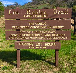
To get here from the Ventura Freeway (U.S. 101), exit at Wendy Drive and head south towards the Santa Monica Mountains. When the road ends in front of the trailheads to the Santa Monica Mountains National Recreation Area on the opposite side of the intersection, make a left on Potrero Road and follow the road for 0.5 miles until the trailhead parking lot appears on the left side of the street.[7]
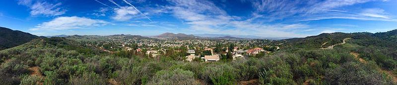
Panoramic view of Newbury Park with the Conejo Mountains in the far back. Taken from the Los Robles Trail.
↑ Riedel, Allen (2011). Best Easy Day Hikes Conejo Valley. Globe Pequot. Pages 60-63. ISBN9781493005000.
↑ Hasenauer, Jim and Mark Langton (1998). Mountain Biking Santa Monica Mountains' Best Trails. Fine Edge Productions. Pages 88-91. ISBN9780938665557.
↑ Stone, Robert (2011). Day Hikes Around Ventura County: 116 Great Hikes. Day Hike Books. Page 185. ISBN9781573422062.
↑ Hasenauer, Jim and Sue Irwin (1995). Mountain Biking the Coast Range: Santa Monica Mountains. FineEdge.Com LLC. Pages 84-85. ISBN9780938665380.
↑ Murphy, Kelly (2012). Local Multi-Use Trails. Kelly Murphy. Page 195. ISBN9781479165599.
Related Research Articles
The Conejo Valley is a region spanning both southeastern Ventura County and northwestern Los Angeles County in Southern California, United States. It is located in the northwestern part of the Greater Los Angeles Area.
Newbury Park is a populated place and town in Ventura County, California, United States. Most of it lies within the western Thousand Oaks city limits, while unincorporated areas include Casa Conejo and Ventu Park. About 28,000 residents of Thousand Oaks reside in Newbury Park. Newbury Park makes up around 40 percent of the total land area of Thousand Oaks. Lying within the Conejo Valley in the northwestern part of the Greater Los Angeles Area, Newbury Park abuts the Santa Monica Mountains. It is approximately 35 miles (56 km) from Downtown Los Angeles and less than 7 mi (11 km) from the Los Angeles County border in Westlake Village. The closest coastal city is Malibu, 22 mi (35 km), which may be reached through winding roads or hiking trails crossing the Santa Monica Mountains. It makes up all of ZIP code 91320, and is within area code 805.
Boney Mountain in Ventura County, California is one of the highest peaks in the Santa Monica Mountains. The prominent mountain visible from Newbury Park, California is 2,825 feet (861 m). It is also known as Boney Peak. The mountain contains four of the highest peaks in the coastal range of the Santa Monica Mountains: Boney Peak, Sandstone Peak, Exchange Peak, and Tri Peaks. The highest summit in the Santa Monica Mountains is Sandstone Peak, situated less than a mile northeast of Boney Peak along the same ridge of volcanic rock. It is the top section of a mass of volcanic rock which solidified around 15 million years ago, and was later uplifted to its dominant position, overshadowing western Conejo Valley. The Chumash Native Americans have a long and deeply spiritual history of interaction at and near the mountain, and the peak is considered a sacred mountain to the Chumash people.
Wildwood Regional Park is a suburban regional park in the western Simi Hills and Conejo Valley, in Ventura County, California. It is located in western Thousand Oaks, northern Newbury Park, and southern Moorpark.
Arroyo Conejo is the longest creek in the Conejo Valley, sprawling over the cities of Thousand Oaks and Camarillo, and the communities of Newbury Park, Casa Conejo and Santa Rosa Valley. Arroyo Conejo is the primary drainage for the City of Thousand Oaks. Its watershed covers 57 square miles (150 km2) of which 43 square miles (110 km2) are in the Conejo Valley and 14 square miles (36 km2) in the Santa Rosa Valley.
Satwiwa was a former Chumash village in the Santa Monica Mountains of Newbury Park, California. The current Satwiwa Native American Indian Culture Center is operated by the National Park Service in cooperation with the Friends of Satwiwa. Satwiwa has been inhabited by Chumash Indians for over 10,000 years. It is situated at the foothills of Boney Mountain, a sacred mountain for the Chumash.
Big Sycamore Canyon, often shortened to Sycamore Canyon, is a major feature of Point Mugu State Park, in Ventura County, California, United States. Sycamore Canyon is situated in the northernmost region of the Santa Monica Mountains National Recreation Area below the 3,000 feet (910 m) peaks of the Boney Mountain State Wilderness Area. The canyon begins on the north slope of Boney Mountain and heads north down the slope. The canyon then heads southwest past Rancho Sierra Vista/Satwiwa to Sycamore Cove on the coastline. The canyon in the park is one of the riparian woodlands along the California coast. It contains a number of California sycamore trees.
Rabbit Hill, also referred to as Knoll Hill, is a 797-foot high hill (243 m) located in Knoll Park, which is among the highest peaks in Newbury Park, California that are not parts of the Santa Monica Mountains. It is reached from a trailhead on North Reino Road, just across the road from the Pepper Tree Playfields, which provides hikers to Rabbit Hill with parking spaces. The sloping Knoll Trail goes from N. Reino Rd. to the top of the knoll, which offers panoramic views of Newbury Park, Casa Conejo, Boney Mountain, Thousand Oaks and Conejo Mountain. The total park area is 21 acres (8.5 ha) including the hill, which is covered with coastal sage scrub and grassland.
Hill Canyon is a deep canyon in the western Simi Hills and within northern Newbury Park and Thousand Oaks, in Ventura County, southern California.
The Conejo Canyons Open Space consists of 1,628 acres (659 ha) of open-space areas in northernmost Newbury Park, Ventura County, California. It consists of deeply eroded canyons, numerous ridgelines and plateaus in the northwestern portion of the Conejo Valley. The area consists of diverse natural features such as deep canyons with perennial streams, prominent ridgelines, volcanic mountains, and a variety of natural habitats. While some of the flora includes chaparral, riparian habitats, oak woodlands and coastal sage, fauna includes mountain lions, coyotes, mule deer, and bobcats.
Knoll Open Space, also known as Knoll Park, is a 21 acres (8.5 ha) open-space area in western Newbury Park, California, United States, adjacent to Pepper Tree Playfield. The Knoll Open Space is owned and operated by the Conejo Open Space Conservation Agency (COSCA), and the flora here includes coastal sage scrub and grass. The 1.9 miles (3.1 km) Knoll Trail goes from its trailhead at North Reino Road and leads to the top of Rabbit Hill. The hill offers panoramic views of the Conejo Valley, Santa Monica Mountains, Conejo Mountain, and Boney Mountain.
The Potrero Ridge Open Space is a passive recreation area in the southwestern portion of Newbury Park, CA and the Conejo Valley that encompasses eastern parts of the Potrero Ridge. The open-space area contains a total of 203 acres (82 ha), and is owned and operated by the Conejo Open Space Conservation Agency (COSCA). It is adjacent to the Dos Vientos Open Space in the west, which provides further access to the Santa Monica Mountains National Recreation Area by Satwiwa, as well as the Alta Vista Open Space, Los Vientos Open Space, and Los Robles Trail which leads to Los Robles Open Space in Thousand Oaks, CA and further into Westlake Village.
Dos Vientos Community Park in southwestern Newbury Park, CA is the largest of Conejo Recreation & Park District’s public parks in the Conejo Valley. It is adjacent to the Dos Vientos Community Center, which offers a preschool, sports, and other activities. The park contains sand volleyball courts, baseball-, basketball- and tennis courts, soccer fields, playground areas, and picnic tables and barbecue grills. It is adjacent to the Dos Vientos Open Space through the Park View Trail, which is a 1,216 acre natural open-space, bordering an additional 16,000 acres of open space stretching over the Santa Monica Mountains National Recreation Area to the Pacific Ocean. The Park View Trail ends at Via Ricardo, directly across the road from the Powerline Trail and Dos Vientos Open Space.
Conejo Mountain is a 1,814-foot-high mountain (553 m) in Ventura County, California near Camarillo on the eastern boundary of the Oxnard Plain. At the western edge of the Conejo Valley, it is adjacent to the Santa Monica Mountains. Crossing what was once a formidable barrier for travelers, U.S. Route 101 passes through the area on the steep Conejo Grade.
Alta Vista Open Space is a 43-acre open-space area in western Newbury Park, California, United States, adjacent to Dos Vientos Open Space and its 1,216 acres of natural open space area and numerous trails. Its primary trail is the Ring Finger Trail, which is reached from its trailhead at the southern side of Calle Alta Vis, directly across the street from Calle Las Collinas. Most of the open-space area is owned by the homeowners association, while eleven acres are owned by the Conejo Open Space Conservation Agency (COSCA). Its flora contain large areas covered with chaparral and coastal sage scrub, while some endangered endemic species include Conejo buckwheat, Verity's dudleya, and Conejo dudleya. It functions as a crucial wildlife corridor into the Santa Monica Mountains National Recreation Area through Point Mugu State Park. Some of the fauna here includes Mountain lions, coyotes, mule deer, bobcats, and more.
Dos Vientos Open Space is a 1,216 acres (492 ha) open space area in western Newbury Park, California. It contains more than 41 miles (66 km) of trails used for cycling, hiking and equestrians. Originally a part of the Rancho Guadalasca Spanish Land Grant of 1836, the area is now an important wildlife movement corridor into the Santa Monica Mountains through the Point Mugu State Park. It provides a habitat for a variety of wildlife, including bobcats, mule deer, coyotes, eagles, hawks, barn owls, mountain lions, and more. It provides regional and internal trail connections, many trails offering panoramic views of the Conejo Valley, Oxnard Plain, Topatopa Mountains, Channel Islands, and the Pacific Ocean. Some of the endangered plant species found here include Conejo buckwheat, Verity's liveforever, and Conejo dudleya. The landscape is undeveloped, and dominated by coastal sage scrub, grassy hillsides, oak woodlands, and chaparral habitats.
Ventu Park Open Space is a 141-acre open space area in Newbury Park, California. Its primary features are the Rosewood Trail leading to Angel Vista, a 1,603 ft peak in the Santa Monica Mountains. Parking for the Rosewood Trail is located at the Stagecoach Inn Park, across Lynn Road from the primary trailhead. The Rosewood Trail begins with oak woodland and crosses a creek at the canyon floor, before climbing up towards the steep Angel Vista Point. There are 360-degree panoramic views of the Conejo Valley, the Oxnard Plain, the California Channel Islands, Pacific Ocean, Point Mugu, Hidden Valley, as well as the Santa Monica-, Santa Susana- and Topa Topa Mountains.
Tarantula Hill, also known as Dawn’s Peak, is a 1,057-foot-high (322 m) peak in Thousand Oaks, California. It is located on a 45-acre (18 ha) open space and is operated by the Conejo Open Space Conservation Agency (COSCA). Climbing Tarantula Hill is a steep 0.5-mile (0.80 km) trail; the trailhead is located at 287 West Gainsborough Road, across the road from the main entrance to Conejo Valley Botanic Garden. Atop the mountain there is a 360-degree panoramic view of the Conejo Valley, the Simi Hills and the Santa Monica Mountains. There is also a fenced-in water reservoir located on top. It was once a popular hang-gliding site. It was once a volcanic mound but went dormant 16 million years ago.
Mount Clef Ridge is a 1,076 ft volcanic mountain in Thousand Oaks, California. It is a volcanic outcrop that resulted from lava eruptions 30 million years ago. The ridge was formerly under ownership by the Janss Corporation, but was acquired by the Conejo Recreation and Park District (CRPD) in 1967. Trails here are available from Santa Rosa Valley, Newbury Park and Wildwood Regional Park. Although being a major feature of Wildwood, it occupies its own open-space area bordering Wildwood's northern boundaries. Mount Clef Ridge Open Space Area occupies 212 acres. From the ridge are great panoramic views of Santa Rosa Valley, Conejo Valley, Hill Canyon, as well as the Santa Susana-, Santa Monica- and Topatopa Mountains. The open-space area is home to plants such as coastal sage scrub, chaparral, Lyon's pentachaeta and Conejo dudleya. The fauna includes mountain lions, deer, coyotes, gray foxes, and more.
Hope Nature Preserve is a 360-acre (150 ha) nature preserve in Newbury Park, California. It was a gift to the city from its owner, actor Bob Hope, whom it is named for. It is located by the Newbury Park-Thousand Oaks “border” in southern Conejo Valley. It is home to a variety of wildlife, including mountain lions, gray fox, bobcats, coyotes, deer, rabbits, and more. The Los Robles Trail provides the principal access, but it can also be visited from a trailhead in Lynn Oaks Park. It connects to a variety of protected open-space areas, including Ventu Park, Deer Ridge, Los Vientos, Los Padres, and many more.
This page is based on this Wikipedia article Text is available under the CC BY-SA 4.0 license; additional terms may apply. Images, videos and audio are available under their respective licenses.