
Cranham is a residential area of east London, and part of the London Borough of Havering. It is located 17.5 miles (28 km) east-northeast of Charing Cross and comprises an extensive built-up area to the north and a low density conservation area to the south surrounded by open land. It was historically a rural village in the county of Essex and formed an ancient parish. It is peripheral to London, forming the eastern edge of the urban sprawl. The economic history of Cranham is characterised by a shift from agriculture to housing development. As part of the suburban growth of London in the 20th century, Cranham significantly increased in population, becoming part of Hornchurch Urban District in 1934 and has formed part of Greater London since 1965. The 2011 Census population of Cranham was included in Upminster.

Harold Wood is a suburban neighbourhood in East London in the London Borough of Havering. It is situated 16.5 miles (26.6 km) east-northeast of Charing Cross. Harold Wood was part of the ancient parish of Hornchurch, which became the Liberty of Havering. Most of the current area of Harold Wood became part of Hornchurch Urban District in 1926. It is near to the Greater London boundary with Essex.

Hornchurch is a suburban town in East London in the London Borough of Havering. It is located 15.2 miles (24.5 km) east-northeast of Charing Cross. It comprises a number of shopping streets and a large residential area. It historically formed a large ancient parish in the county of Essex that became the manor and liberty of Havering. The economic history of Hornchurch is underpinned by a shift away from agriculture to other industries with the growing significance of nearby Romford as a market town and centre of administration. As part of the suburban growth of London in the 20th century, Hornchurch significantly expanded and increased in population, becoming an urban district in 1926 and has formed part of Greater London since 1965. It is the location of Queen's Theatre, Havering Sixth Form College and Havering College of Further and Higher Education.

Upminster is a suburban town in East London, England, within the London Borough of Havering. Located 16.5 miles (26.6 km) east-northeast of Charing Cross, it is one of the locally important district centres identified in the London Plan.

The London Borough of Havering in East London, England, forms part of Outer London. It has a population of 259,552 inhabitants; the principal town is Romford, while other communities include Hornchurch, Upminster, Collier Row and Rainham. The borough is mainly suburban, with large areas of protected open space. Romford is a major retail and night time entertainment centre, and to the south the borough extends into the London Riverside redevelopment area of the Thames Gateway. The name Havering is a reference to the Royal Liberty of Havering which occupied the area for several centuries. The local authority is Havering London Borough Council. It is the easternmost London borough.
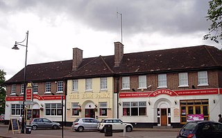
Elm Park is a suburban planned community in East London and part of the London Borough of Havering. Located 14.3 miles (23.0 km) east-northeast of Charing Cross, it is identified as a district centre in the London Plan with several streets of shops and a priority for regeneration. Prior to the construction of the extensive Elm Park Garden City development in the 1930s it was a scattered settlement of farms in the south of the parish of Hornchurch. Elm Park has been connected to central London by the electrified District line service since 1935 and the planned development of the area formed part of the interwar private housing boom that was interrupted by World War II. After the war Elm Park expanded with social housing and it has formed part of Greater London since 1965.

Emerson Park is a suburban neighbourhood in the London Borough of Havering, east London. The neighbourhood developed as two large housing estates built on the 550 acres (2.2 km2) estate of Nelmes manor in the parish of Hornchurch. Emerson Park estate to the south started construction in 1895 and Great Nelmes estate to the north was begun in 1901. It is located north of the Romford–Upminster line and a station opened at Emerson Park in 1909. The mansion of Nelmes survived until it was demolished in 1967 to avoid preservation by the Civic Amenities Act and was replaced with a small housing estate called The Witherings. Emerson Park is located 15 miles (24.1 km) northeast of Charing Cross in Central London.

Wennington is a small village in the London Borough of Havering, in east London. It is situated 14.8 miles (23.8 km) east of Charing Cross. Wennington was an ancient parish in the county of Essex that was abolished for civil purposes in 1934. It is peripheral to London, forming a ribbon development extending from the eastern edge of the urban sprawl and surrounded by the Metropolitan Green Belt. Wennington was added to Hornchurch Urban District in 1934 and has formed part of Greater London since 1965.
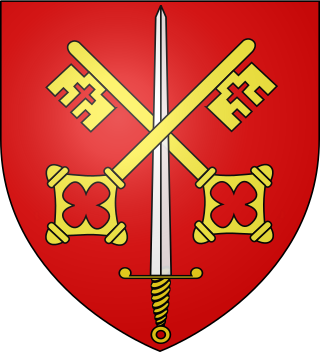
Havering, also known as Havering-atte-Bower, was a royal manor and ancient liberty whose area now forms part of, and gives its name to, the London Borough of Havering in Greater London. The manor was in the possession of the Crown from the 11th to the 19th centuries and was the location of Havering Palace from the 13th to the late 17th century. It occupied the same area as the ancient parish of Hornchurch which was divided into the three chapelries of Havering, Hornchurch and Romford.
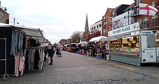
Romford Market is a large outdoor retail market located in Romford in the London Borough of Havering, England. The market right was established by royal order in 1247. Rival markets are prohibited within 6.66 miles (10.72 km). Governance of the market was strengthened by the 1465 charter of the Liberty of Havering, which was administered from a court house at the western end of the market. Formerly a livestock and agricultural market, cattle was last sold in 1958. The market has been in local authority ownership since it was purchased by the Romford Local Board in 1892 and is now owned by Havering Council. The marketplace was located on the main east–west road through the town until traffic was diverted away from the market in 1969. The market is promoted as a filming location. It is open on Wednesday, Friday and Saturday. There was a Sunday market from July 2020 to March 2024. As of July 2020 it has 60 licensed traders, down from a peak of over 300.

Alien priories were religious establishments in England, such as monasteries and convents, which were under the control of another religious house outside England. Usually the mother-house was in France.
Marshalls was a house, located in Romford in the historic parish and Royal liberty of Havering, whose former area today forms the north eastern extremity of Greater London, England. The name Marshalls dates back to 1213 when Gilbert, son of Roger Marschal is recorded as leasing land in Havering to the house of Canons at St Bernard, and in 1321 Richard le Marescall owned land near the eventual site of the house. Marshalls was situated roughly where the playground of the current St Edwards' C of E Primary school is now, and at its greatest the surrounding estate was approximately bounded by the modern roads of Main Road, North Street, Pettits Lane, and Pettits Boulevard.

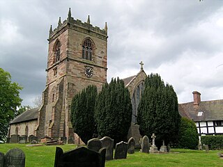
The church of St Andrew's, Hornchurch, is a Church of England religious building in Hornchurch in England. It is a Grade I listed building.

Hornchurch Marshes is an area of the London Borough of Havering, adjacent to the north bank of the River Thames in London, England. Susceptible to flooding from three adjacent rivers, it was the southernmost marshland section of the ancient parish of Hornchurch. It was used for cattle grazing from the 16th to the 19th century and became industrialised by the 20th century. The eastern part of the Ford Dagenham estate extended into the Hornchurch Marshes and it is now an area of regeneration that includes Beam Reach and part of Beam Park. Two of the Dagenham wind turbines are located there and the Centre for Engineering and Manufacturing Excellence.
Pamber Priory is a Church of England parish church and former priory, then known as West Sherborne Priory or Monk Sherborne Priory, at Monk Sherborne in the English county of Hampshire.
Lapley Priory was a priory in Staffordshire, England. Founded at the very end of the Anglo-Saxon period, it was an alien priory, a satellite house of the Benedictine Abbey of Saint-Remi or Saint-Rémy at Reims in Northern France. After great fluctuations in fortune, resulting from changing relations between the rulers of England and France, it was finally dissolved in 1415 and its assets transferred to the collegiate church at Tong, Shropshire.

St George's Hospital was a hospital on Suttons Lane in Hornchurch in the London Borough of Havering, in northeast London, England. It opened in 1938 and closed in October 2012.
St. James Priory, also known as Derby Cluniac Priory, was a Benedictine monastery, formerly located in what is now Derby City Centre. It existed until the Dissolution of the Monasteries.

Marks was a manor house located near Marks Gate at the northern tip of the London Borough of Barking and Dagenham in London, England, the house standing on what is now Warren Hall Farm, about two miles west of Romford. The name Marks is believed to have been derived from the de Merk family who built the original manor in the 14th century. The manor house was demolished in 1808.
