
Aust-Agder was one 18 counties (fylker) in Norway up to 1 January 2020, when it was merged with Vest-Agder to form Agder county. In 2002, there were 102,945 inhabitants, which was 2.2% of Norway's population. Its area was 9,212 square kilometres (3,557 sq mi). The county's administrative center was the town of Arendal.

Vennesla is a municipality in Agder county, Norway. It is located in the traditional district of Sørlandet. The administrative centre of the municipality is the village of Vennesla. Other villages in Vennesla include Grovane, Hægeland, Homstean, Mushom, Øvre Eikeland, Øvrebø, Røyknes, and Skarpengland. Vennesla lies about 17 kilometres (11 mi) north of the city of Kristiansand in the Otra river valley.

Froland is a municipality in Agder county, Norway. It is part of the traditional region of Sørlandet. The administrative center is the village of Blakstad, which along with Osedalen form the main population center of the municipality. Other villages in Froland include Bøylefoss, Bøylestad, Froland, Frolands verk, Heldalsmo, Hinnebu, Hynnekleiv, Jomås, Lauvrak, Libru, Løvjomås, Mjåvatn, Mjølhus, Mykland, and Risdal.

Birkenes is a municipality in Agder county, Norway. It is located in the traditional district of Sørlandet. The administrative centre of the municipality is the village of Birkeland, where about half the municipal population lives. Other villages in Birkenes include Ås, Engesland, Flakk, Håbbesland, Herefoss, Mollestad, Oggevatn, Rugsland, Senumstad, Søre Herefoss, Svaland, Tveide, and Væting.

Iveland is a municipality in Agder county, Norway. It is located in the traditional district of Setesdal. The administrative centre of the municipality is the village of Birketveit. Other villages in the municipality include Bakken, Skaiå, and Vatnestrøm.
Evje og Hornnes is a municipality in Agder county, Norway. It is located in the traditional district of Setesdal. The administrative centre of the municipality is the village of Evje. Other villages in the municipality include Åneland, Dåsnesmoen, Flatebygd, Gautestad, Hornnes, Kjetså, and Øvre Dåsvatn. Evje og Hornnes was created as a new municipality on 1 January 1960 after the merger of the two older municipalities of Evje and Hornnes. The Norwegian National Road 9 runs north–south through the municipality, along the river Otra.

Bygland is a municipality in Agder county, Norway. It is located in the traditional district of Setesdal. The administrative centre of the municipality is the village of Bygland. Other villages in the municipality include Åraksbø, Austad, Byglandsfjord, Grendi, Langeid, Lauvdal, Litveit, Longerak, Moi, Ose, Sandnes, Skåmedal, and Tveit. The Norwegian National Road 9 runs through the municipality, following the river Otra where most of the population of Bygland lives.

Valle is a municipality in Agder county, Norway. It is located in the traditional district of Setesdal. The administrative centre of the municipality is the village of Valle. Other villages in Valle include Besteland, Brokke, Homme, Hovet, Rygnestad, Rysstad, and Uppstad.
Setesdal is a valley and a traditional district in Agder County in southern Norway. It consists of the municipalities of Bykle, Valle, Bygland, Iveland, and Evje og Hornnes.

Kilefjorden is a lake on in Agder county, Norway. The lake is located on the border of the municipalities of Evje og Hornnes, Iveland, and Vennesla. The lake is part of the river Otra. The lake is located about 6 kilometres (3.7 mi) west of the village of Birketveit in Iveland, about 2.5 kilometres (1.6 mi) north of the village of Hægeland in Vennesla, and about 15 kilometres (9.3 mi) south of the village of Hornnes in Evje og Hornnes.
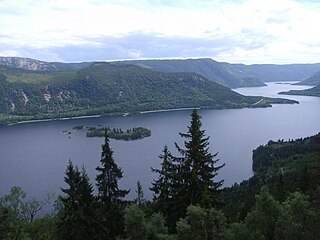
Byglandsfjorden is a lake in Agder county, Norway. The 32.79-square-kilometre (12.66 sq mi) lake lies on the river Otra, primarily in the municipality of Bygland, but the far southern tip of the lake extends into the neighboring municipality of Evje og Hornnes. The river flows out of the lake Åraksfjorden to the north and into the Byglandsfjorden through a narrow channel, and the southern end of the Byglandsfjorden is marked by a dam along the river. The villages of Byglandsfjord, Grendi, Longerak, Lauvdal, and Bygland are all located on the eastern shore of the lake along the Norwegian National Road 9. The western shore of the lake is much more sparsely populated, with County Road 304 following that shoreline.

Evje og Vegusdal is a former municipality in Aust-Agder county, Norway. It was located in the Setesdal region in Southern Norway in parts of the present-day municipalities of Evje og Hornnes and Birkenes. The administrative centre was the village of Evje where the Evje Church is located.

Hornnes og Iveland is a former municipality in Aust-Agder county, Norway. The 640-square-kilometre (250 sq mi) municipality included all of the present-day municipality of Iveland and the western half of the present-day municipality of Evje og Hornnes in the Setesdal region. The administrative centre was the village of Hornnes where the Hornnes Church is located. The other church in the municipality was the Iveland Church in the village of Birketveit.
Hornnes is a former municipality in Aust-Agder county, Norway. Hornnes is located within the present-day municipality of Evje og Hornnes in the traditional district of Setesdal. The 378-square-kilometre (146 sq mi) municipality of Hornnes existed from 1886 until 1960. The administrative centre was the village of Hornnes where the Hornnes Church is located.

Evje is a former municipality in Aust-Agder county, Norway. The municipality was located in what is now the eastern part of the present-day municipality of Evje og Hornnes in the Setesdal valley region. The administrative centre was the village of Evje where the Evje Church is located. The lake Høvringsvatnet is located about 10 kilometres (6.2 mi) northeast of the village.
Dåsnesmoen or Dåsnesmonen is a village in Evje og Hornnes municipality in Agder county, Norway. The village is located on the west shore of the river Otra, north of the villages of Hornnes and Kjetså and southwest of the village of Evje. The Norwegian National Road 9 runs through the village.
Kjetså is a village in Evje og Hornnes municipality in Agder county, Norway. The village is located on the western shore of the river Otra, just south of the villages of Hornnes and Dåsnesmoen.

Oddernes is a former municipality that was located in the old Vest-Agder county in Norway. The 103-square-kilometre (40 sq mi) municipality existed from 1838 until its dissolution in 1964. The administrative centre was the village of Lund on the east side of the river Otra near where Lund Church is located. The former area of the municipality makes up the area just west of the urban town of Kristiansand within the municipality of Kristiansand in Agder county. The old municipality encircled the town of Kristiansand, and it included the villages such as Flekkerøy, Vågsbygd, Slettheia, Lund, Strai, Mosby, and Justvik. Today, the town of Kristiansand has a borough named Oddernes, but it has very different boundaries than the old municipality had.
Evje is the administrative centre of Evje og Hornnes municipality in Agder county, Norway. The village is located along the river Otra. It sits along the Norwegian National Road 9, about 10 kilometres (6.2 mi) south of the village of Byglandsfjorden and immediately north of Evjemoen, a former military base. Historically, the village of Evje was the administrative centre of the municipality of Evje og Vegusdal from 1838 until 1877, then from 1877 until 1960 it was the administrative centre of the municipality of Evje, and since then it has been the centre of Evje og Hornnes municipality.

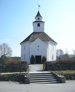
Evje Church is the main parish church in Evje og Hornnes municipality in Agder county, Norway. It is located at the north end of the village of Evje, just east of the river Otra. The church is part of the Evje parish in the Otredal deanery in the Diocese of Agder og Telemark. The white, wooden church was built in a cruciform style in 1891 by builder Ludvig Karlsen. The church was consecrated on 16 December 1891 by the Bishop Johan Christian Heuch. The church seats about 450 people. There are no old historic or artistic pieces in the church, everything in it was new when it was built in 1891.


