Zuniga Glacier is a glacier flowing west-northwest into Dotson Ice Shelf between Jeffrey Head and Mount Bodziony on the west side of Bear Peninsula, Walgreen Coast, Marie Byrd Land. Mapped by United States Geological Survey (USGS) from aerial photographs taken by U.S. Navy Operation Highjump in 1947 and U.S. Navy in 1966, it was named by Advisory Committee on Antarctic Names (US-ACAN) after Mike Zuniga, Chief Aviation Storekeeper, U.S. Navy, who made seven Deep Freeze deployments between 1960 and 1978.

Shoesmith Glacier is the largest glacier on Horseshoe Island, flowing westward into both Lystad Bay and Gaul Cove. Named by United Kingdom Antarctic Place-Names Committee (UK-APC) in 1958 in association with Horseshoe Island.
Simmons Glacier is a glacier draining northward between Mount Isherwood and Mount Strange in the east part of the Kohler Range, Marie Byrd Land. Mapped by United States Geological Survey (USGS) from surveys and U.S. Navy air photos, 1959-66. Named by Advisory Committee on Antarctic Names (US-ACAN) for Harry S. Simmons, assistant to the United States Antarctic Research Program (USARP) Representative in Christchurch, New Zealand, for four seasons, 1969-70 through 1972-73. His duties took him to Antarctica in 1971 and 1973.
Zephyr Glacier 1 is a glacier, about 8 miles long, flowing westward from the southwest side of Mount Edgell into George VI Sound to the south of Cape Jeremy. The feature was surveyed by Falkland Islands Dependencies Survey (FIDS), 1948, and British Antarctic Survey (BAS), 1971-72; photographed from the air by U.S. Navy, 1966. Named by United Kingdom Antarctic Place-Names Committee (UK-APC) in 1977 after Zephyrus, the west wind. One of several features in this area named after winds.
Haffner Pass is a pass running northeast–southwest and rising to about 500 metres (1,600 ft) between Gilbert Glacier and Mozart Ice Piedmont in northern Alexander Island, Antarctica. It was surveyed by the British Antarctic Survey, 1975–77, and was named by the UK Antarctic Place-Names Committee in 1980 after Wolfgang Amadeus Mozart's Haffner Symphony (1782) in association with the name of the Mozart Ice Piedmont.

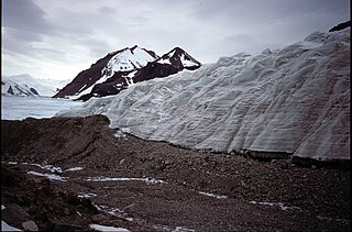
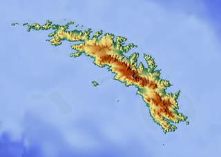
Kjerulf Glacier, Norwegian: Kjerulfbreen, is a glacier 7 nautical miles (13 km) long flowing west from Mount Sugartop to the east side of Newark Bay, on the south coast of South Georgia. It was mapped by Olaf Holtedahl during his visit to South Georgia in 1927–28, and named by him for Norwegian geologist Theodor Kjerulf, Professor of Mineralogy at the University of Christiania.

Arago Glacier is a glacier flowing into Andvord Bay just northwest of Moser Glacier, on the west coast of Graham Land. It was mapped by the Falkland Islands Dependencies Survey from air photos taken by Hunting Aerosurveys Ltd in 1956–57, and named by the United Kingdom Antarctic Place-Names Committee in 1960 for François Arago, the French geodesist who first demonstrated the application of photography to mapmaking in 1839.

Beakley Glacier is a glacier on the west side of the Duncan Peninsula on Carney Island, flowing north into the Amundsen Sea. It was delineated by the United States Geological Survey from aerial photos taken by U.S. Navy Operation Highjump in January 1947, and named by the Advisory Committee on Antarctic Names for Vice Admiral W.M. Beakley, U.S. Navy, Deputy Chief of Naval Operations for Ship Operations and Readiness during the IGY period, 1957–58.

Blaiklock Glacier is a glacier 16 nautical miles (30 km) long, flowing north from Turnpike Bluff, then northwest to Mount Provender and Mount Lowe in the western part of the Shackleton Range. It was first mapped in 1957 by the Commonwealth Trans-Antarctic Expedition (CTAE), and named for Kenneth V. Blaiklock, the leader of the advance party of the CTAE in 1955–56 and a surveyor with the transpolar party in 1956–58.
The Cathedral Rocks are a series of four abrupt cliffs interspersed by short glaciers and surmounted by sharp peaks. The cliffs extend for 8 nautical miles (15 km) along the south side of Ferrar Glacier and form part of the north shoulder of the Royal Society Range, in Victoria Land. They were discovered and named on December 7, 1902 by Lieutenant A.B. Armitage, leader of a party of the British National Antarctic Expedition, 1901–04, that explored this area. The name is descriptive of the feature.
Whistle Pass is a snow pass at about 1,050 m at the head of Sullivan Glacier in north Alexander Island, Antarctica. The pass trends in a NE-SW direction and provides access to and from the upper part of Hampton Glacier. So named by British Antarctic Survey in 1977, because the pass falls away steeply to the southwest between high cliffs, so that the descent by sledge is fast and exhilarating as suggested by the name.
Cronus Glacier is a glacier 6 nautical miles (11 km) long and 3 nautical miles (6 km) wide flowing northwest into Bowman Inlet between the Calypso Cliffs and Crabeater Point on the east coast of the Antarctic Peninsula. It was photographed by the Ronne Antarctic Research Expedition on December 22, 1947, and roughly surveyed by the Falkland Islands Dependencies Survey in December 1958. It was named by the UK Antarctic Place-Names Committee after Cronus, the god of agriculture in Greek mythology.
Daniels Hill is a prominent solitary nunatak that rises above the ice in the eastern part of the Dyer Plateau of Palmer Land, approximately 15 nautical miles (30 km) west of the head of Clifford Glacier. It was mapped by the United States Geological Survey in 1974, and named by the Advisory Committee on Antarctic Names for Robert Daniels, a United States Antarctic Research Program biologist at Palmer Station, 1975.
The Elgar Uplands are uplands rising to 1,900 metres (6,200 ft), between Tufts Pass to the north and Sullivan Glacier to the south, in the northern part of Alexander Island, Antarctica. They were first photographed from the air and roughly mapped by the British Graham Land Expedition in 1937. They were remapped from air photos taken by the Ronne Antarctic Research Expedition, 1947–48, by D. Searle of the Falkland Islands Dependencies Survey in 1960, and from U.S. Landsat imagery of February, 1975. They were named by the UK Antarctic Place-Names Committee after Sir Edward Elgar, the English composer (1857-1934).
Gerontius Glacier is a glacier flowing north from the Elgar Uplands into Tufts Pass in northern Alexander Island, Antarctica. It was so named by the UK Antarctic Place-Names Committee in 1977, association with the nearby uplands, from The Dream of Gerontius, a work for chorus, solo voices and orchestra by Edward Elgar.
Moser Glacier is a glacier flowing into Andvord Bay just southeast of Arago Glacier, on the west coast of Graham Land, Antarctica. It was charted by the Belgian Antarctic Expedition under Adrien de Gerlache, 1897–99, and was named by the UK Antarctic Place-Names Committee in 1960 for German physicist Ludwig F. Moser (1805–80), who in 1844 invented stereoscopic photography.
The Hitchcock Heights are a mostly ice-covered mountain mass, 1,800 metres (5,900 ft) high, between Maitland Glacier and Apollo Glacier at the south side of Mobiloil Inlet, on the east coast of the Antarctic Peninsula. They were discovered and photographed by Sir Hubert Wilkins on his flight of December 20, 1928, and rephotographed by Lincoln Ellsworth in 1935. The feature was named by the Advisory Committee on Antarctic Names in 1952 for Charles B. Hitchcock of the American Geographical Society, who by utilizing these photographs assisted in constructing the first reconnaissance map of this area.

Mount Malone is a big mountain, 2,460 metres (8,070 ft) high, located 8 nautical miles (15 km) east of Mount Barden in the northern part of the Sentinel Range of the Ellsworth Mountains in Antarctica. It is the summit of Sostra Heights, surmounting Sabazios Glacier to the west and Anchialus Glacier to the northeast.
Sedgwick Glacier is a glacier on the east coast of Alexander Island, Antarctica, 7 nautical miles (13 km) long and 2 nautical miles (3.7 km) wide, which flows east from the foot of Mount Stephenson into George VI Sound immediately north of Mount Huckle. The glacier was first roughly surveyed in 1936 by the British Graham Land Expedition under Rymill. Resurveyed in 1948 by the Falkland Islands Dependencies Survey and named by them for Adam Sedgwick, English geologist and professor of geology at Cambridge University, 1818-73.
Kellogg Glacier is a glacier about 9 nautical miles (17 km) long at the base of Condor Peninsula on the east side of Palmer Land, Antarctica. The glacier flows southeast along the north side of Boyer Spur and merges with the north side of Gruening Glacier just inland from the northwest head of Hilton Inlet. It was mapped by the United States Geological Survey (USGS) in 1974, and was named by the Advisory Committee on Antarctic Names for geologist Karl S. Kellogg, a member of the USGS Lassiter Coast party in 1972–73.


