
May 2006
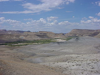
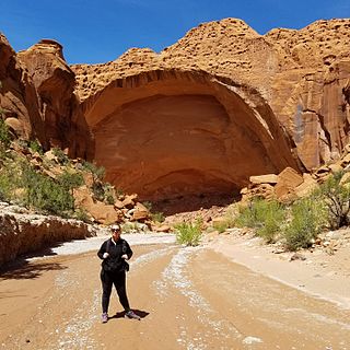
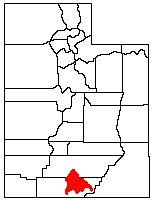
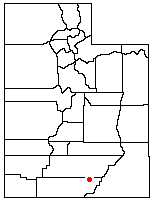
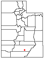
Horse Canyon is a small canyon near the towns of Boulder and Escalante in the Grand Staircase-Escalante National Monument in central Garfield County, Utah, United States [1]
Horse Canyon is a small canyon near the towns of Boulder and Escalante in the Grand Staircase-Escalante National Monument in central Garfield County, Utah, United States [1]
The canyon is one of the three canyons which meet at a fork and turn into Horse Canyon, which is followed down to the Escalante River. Death Hollow meets up with Horse Canyon about 5 miles (8.0 km) in. Wolverine Canyon meets with Horse Canyon about 3.5 miles (5.6 km) in. [2]

Garfield County is a county in south central Utah, United States. As of the 2010 United States Census the population was 5,172, making it the fifth-least populous county in Utah. Its county seat and largest city is Panguitch.

Kane County is a county in the U.S. state of Utah. As of the 2010 United States Census, the population was 7,125. Its county seat and largest city is Kanab.

Escalante is a city in central Garfield County, Utah, United States located along Utah Scenic Byway 12 (SR-12) in the south central part of the state. As of the 2010 census, there were 797 people living in the city.

Henrieville is a town in Garfield County, Utah, United States, along Utah Scenic Byway 12. As of the 2010 census, the town population was 230, up from 159 at the 2000 census.

The Escalante River is a tributary of the Colorado River. It is formed by the confluence of Upper Valley and Birch Creeks near the town of Escalante in south-central Utah, and from there flows southeast for approximately 90 miles (140 km) before joining Lake Powell. Its watershed includes the high forested slopes of the Aquarius Plateau, the east slope of the Kaiparowits Plateau and the high desert north of Lake Powell. It was the last river of its size to be discovered in the 48 contiguous U.S. states. The average discharge is approximately 146 cfs.

The Paunsaugunt Plateau is a dissected plateau, rising to an elevation of 7,000–9,300 feet (2,100–2,800 m), in southwestern Utah in the United States. Located in northern Kane County and southwestern Garfield County, it is approximately 10 miles (16 km) wide, and extends southward from the Sevier Plateau approximately 25 miles (40 km), terminating in the Pink Cliffs at the southern end.
State Route 12 or Scenic Byway 12 (SR-12), also known as "Highway 12 — A Journey Through Time Scenic Byway", is a 122.863-mile-long (197.729 km) state highway designated an All-American Road located in Garfield County and Wayne County, Utah, United States.

The Buckskin Gulch, a canyon in southern Utah, is one of the main tributaries of the Paria River, which is itself a minor tributary of the Colorado River. It is the longest and deepest slot canyon in the southwest United States and may be the longest in the world. As such it is one of the premier destinations for slot canyon hikers, and receives a high amount of foot traffic.

Padre Bay is a bay within Lake Powell, on the Colorado River in Kane County and San Juan County, Utah. Its waters reach an elevation of 3704 feet / 1129 meters. Located 13.5 miles northeast of Glen Canyon Dam in Lake Powell, Padre Bay is the largest expanse of open water on the man made lake. Padre Bay is bounded by Alstrom Point and the island of Gunsight Butte on the west and Gooseneck Point on the east. Cookie Jar Butte lies between them on the north shore of the bay. At the southern mouth of the bay, north of Dominguez Butte on the south shore is Padres Butte, formerly an island, now with lower water in the lake the tip of Padre Point. Padres Butte marks the location of the Crossing of the Fathers, which is approximately a mile west of the butte. It currently lies under nearly four hundred feet of water.
Road 400 is a scenic 47-mile (76 km) dirt road in Kane County, Utah, United States that connects U.S. Route 89 (US-89) with South Kodachrome Road. The road traverses portions of Grand Staircase-Escalante National Monument offering a unique view into the heart of the Monument. This road is considered impassable in wet weather and high clearance vehicles are recommended.

It is located on the East side of the Escalante River Southeast of the town of Escalante, Utah. Not to be confused with the much longer and deeper Death Hollow upstream and directly to the East of the town.
Wolverine Canyon, UT is a canyon near the town of Boulder, Utah. It is small, only 3 miles in length until it meets with Horse Canyon and Little Death Hollow, and then leads down to the Escalante River.
The Kaiparowits Plateau is a large, elevated landform located in southern Utah, in the southwestern United States. Along with the Grand Staircase and the Canyons of the Escalante, it makes up a significant portion of the Grand Staircase-Escalante National Monument. Its extension to the southeast, Fiftymile Mountain, runs nearly to the Colorado River and Lake Powell, and is a prominent part of the northern skyline from the Glen Canyon National Recreation Area.

The Hole in the Rock Trail is a historic trail running east-southeast from the town of Escalante in southern Utah in the western United States. The Mormon trailblazers who established this trail crossed the Colorado River and ended their journey in the town of Bluff. The Hole-in-the-Rock expedition established the trail in 1879. The trail is located within the borders of the Grand Staircase-Escalante National Monument, the adjacent Glen Canyon National Recreation Area and federal Bureau of Land Management (BLM) public land to the east of the Colorado River. A geologic feature called the Hole in the Rock gave the trail its name. A modern unpaved road called the Hole-in-the-Rock Road closely follows this historic trail to the point where it enters the Glen Canyon National Recreation Area. The modern road is an important access route for visiting the Canyons of the Escalante and the Devils Garden. The trail is listed on the National Register of Historic Places, being added to that list in 1982.

The Canyons of the Escalante is a collective name for the erosional landforms created by the Escalante River and its tributaries—the Escalante River Basin. Located in southern Utah in the western United States, these sandstone features include high vertical canyon walls, numerous slot canyons, waterpockets, domes, hoodoos, natural arches and bridges. This area—extending over 1,500 square miles (3,885 km2) and rising in elevation from 3,600 ft (1,097 m) to over 11,000 ft (3,353 m)—is one of the three main sections of the Grand Staircase-Escalante National Monument, and also a part of the Glen Canyon National Recreation Area, with Capitol Reef National Park being adjacent to the east.
Coyote Gulch is a tributary of the Escalante River, located in Garfield and Kane Counties in southern Utah, in the western United States. Over 25 mi (40 km) long, Coyote Gulch exhibits many of the geologic features found in the Canyons of the Escalante, including high vertical canyon walls, narrow slot canyons, domes, arches, and natural bridges. The upper sections of Coyote Gulch are located within the Grand Staircase-Escalante National Monument while its lower sections are located in the Glen Canyon National Recreation Area.
Fortymile Gulch and Willow Gulch are tributaries of the Escalante River, located in Kane County in southern Utah, in the western United States. With a combined length of over 20 miles (30 km), they exhibit many of the geologic features found in the Canyons of the Escalante, including high vertical canyon walls, water pools, narrow slot canyons, domes, and arches. Popular recreational destinations, they are located within the Grand Staircase-Escalante National Monument.
Harris Wash is a long tributary of the Escalante River located in Garfield County in southern Utah, in the western United States. Over 40 miles (64 km) long, it exhibits many of the geologic features found in the Canyons of the Escalante, including high vertical canyon walls and narrow slot canyons. A popular recreational destination and a historic transportation route, it is located within the Grand Staircase-Escalante National Monument.

The Devils Garden of the Grand Staircase–Escalante National Monument (GSENM) in south central Utah, United States, is a protected area featuring hoodoos, natural arches and other sandstone formations. The United States Geological Survey (USGS) designated the name Devils Garden on December 31, 1979. The area is also known as the Devils Garden Outstanding Natural Area within the National Landscape Conservation System.
Cyclone Lake is a lake in Garfield County, Utah, United States. The lake is about 15 miles (24 km) north-northwest of Escalante and is located within the Dixie National Forest with an elevation of 9,869 feet (3,008 m).
Coordinates: 37°43′08″N111°15′59″W / 37.71889°N 111.26639°W
| This article about a location in Utah is a stub. You can help Wikipedia by expanding it. |