Killerby is a village in the borough of Darlington and the ceremonial county of County Durham, England. It is situated a few miles to the west of Darlington. At the 2011 Census the population was less than 100. Details are maintained in the parish of Staindrop.

Cornsay is a hamlet and civil parish in County Durham, England. The population of the Civil Parish taken at the 2011 census was 1,128. It is 6 miles (9.7 km) southeast of Consett and 7 miles (11 km) southwest of Durham. It consists of nineteen dwellings, including four farms & is the home of Greenacres Nudist club. All formerly belonged to Ushaw College for the training of Catholic priests, hence the organised nomenclature. East and West Farms are now in private hands as homes but the other two are still active, South Farm run by the Suddes family and North Farm by the Tweddle family.

Beaumont Hill is a village in the borough of Darlington and the traditional and ceremonial counties of Durham in England, situated directly to the north of Darlington on the A167 road.
Ingleton is a village and civil parish in County Durham, England. The population of the parish as taken at the 2011 census was 420. It is situated about eight miles to the west of Darlington, and a short distance from the villages of Langton, Hilton and Killerby. The Church of St John the Evangelist in Ingleton was built in 1843 by Ignatius Bonomi and J.A. Cory., and is a Grade II listed building.
Clough Dene is a village in County Durham, England. It is situated a short distance to the north of Tantobie, a few miles from Stanley and Annfield Plain.

Cornriggs is a hamlet in County Durham, England. It is situated on the north side of Weardale, between Lanehead and Cowshill.
Houghton Bank is a village in the borough of Darlington and the ceremonial county of County Durham, England. It is situated a few miles west of Newton Aycliffe, on the A68 between Darlington and Bishop Auckland.
Houghton-le-Side is a small village in the borough of Darlington and the ceremonial county of County Durham, England. It is situated a few miles to the south-west of Newton Aycliffe. The population at the 2011 Census was less than 100. Details are now maintained within the parish of Walworth.
Hummersknott is an area in the western end of Darlington, County Durham England. It is a ward in the unitary authority of Darlington. It consists of mainly post-war houses, and is closely linked to the Mowden. The population of the ward taken at the 2011 Census was 3,478.
Morton Tinmouth is a village or, perhaps more accurately, a hamlet of a few farms in County Durham, England. It is situated a few miles to the north-west of Darlington close to the village of Bolam.
Great Stainton is a village in the borough of Darlington and ceremonial county of County Durham, England. It is situated to the north of Darlington, and to the west of Stockton-on-Tees. Elstob is a hamlet, just north of Great Stainton, which is part of the Parish of Great Stainton. The population as taken at the Census 2011 was less than 100. Details are now maintained in the parish of Little Stainton.
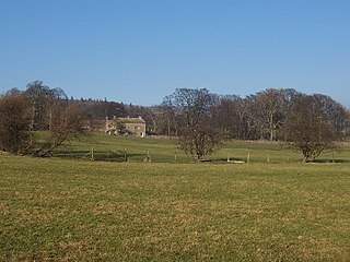
Headlam is a village in the borough of Darlington and the ceremonial county of County Durham, England. It lies to the west of Darlington. The population taken at the 2011 Census was less than 100. Details are included in the parish of Ingleton. The hamlet has 14 stone houses plus 17th-century Headlam Hall, now a country house hotel. The village is set around a village green with a medieval cattle-pound and an old stone packhorse bridge across the beck. Headlam is classed as Lower Teesdale and has views to the south as far as Richmond and to the Cleveland Hills in the east.

Allerton Mauleverer with Hopperton is a civil parish in the Harrogate district of North Yorkshire, England. According to the 2001 census it had a population of 130, increasing to 150 at the 2011 Census.

Bulkworthy is a village and civil parish in the Torridge district of Devon, England, about 9 miles southwest of Great Torrington, and on the River Torridge. According to the 2001 census it had a population of 83.
Croxdale and Hett is a civil parish in County Durham, England. It is situated approximately four miles south of Durham. The population of the civil parish as taken at the 2011 census was 866.
Whinney Hill is a village within the borough of Stockton-on-Tees and the ceremonial county of County Durham, England. Whinney Hill lies 2 miles (3.2 km) west of Stockton-on-Tees.

Carlin How is a village in the borough of Redcar and Cleveland and the ceremonial county of North Yorkshire, England.

Margrove Park is a village in the borough of Redcar and Cleveland and the ceremonial county of North Yorkshire, England.
Gammersgill is a hamlet in Coverdale in the Yorkshire Dales, North Yorkshire, England. It is about 7 miles south-west of Leyburn.

Mount Pleasant is a hamlet in the parish of Roche, Cornwall, England. The main A30 road used to pass through the hamlet but a dual carriageway bypass and graded junction have been constructed to the south of the original road. There is a Grade II listed eighteenth century guidestone beside the old road, consisting of a 5-foot (1.5 m) granite monolith with a rounded head. The text "WITHIEL" is carved into it, and the letters are painted.


