

The Horti Aciliorum was a luxurious villa-estate in the city of Rome, created in the 2nd century AD on the Pincian Hill, between the Porta Pinciana and what is now the Spanish Steps.
The Horti Aciliorum was a luxurious villa-estate in the city of Rome, created in the 2nd century AD on the Pincian Hill, between the Porta Pinciana and what is now the Spanish Steps.
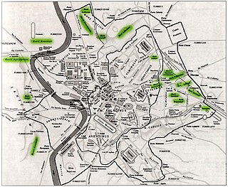
Surrounded to the north, west and east by opus reticulatum retaining walls built along the slopes of the hill, the northern and eastern walls were later incorporated into the Aurelian Walls and so can be partially reconstructed. The northern part is the famous 'Muro Torto'. It was shaped as a wide semicircle, opening to the west, with a staircase leading down to the plain below to the north of the present-day Spanish Steps. It included a two-section piscina (swimming pool) connected to a cistern, consisting of a maze of small tunnels dug into the rock – the hill in the gardens of the current Villa Medici was built on the ruins of the 'Parnassus', an octagonal nymphaeum.
The gardens belonged to the Anicii Glabriones, [1] who had them built. In the 4th century they passed to the gens Pincia then to Anicia Faltonia Proba and her husband Sextus Petronius Probus, [2] before finally becoming state property.

The Quirinal Hill is one of the Seven Hills of Rome, at the north-east of the city center. It is the location of the official residence of the Italian head of state, who resides in the Quirinal Palace; by metonymy "the Quirinal" has come to stand for the Italian president. The Quirinal Palace has an extension of 1.2 million square feet.
The Gardens of Lucullus were the setting for an ancient villa on the Pincian Hill on the edge of Rome; they were laid out by Lucius Licinius Lucullus about 60 BC. The Villa Borghese gardens still cover 17 acres (6.9 ha) of green on the site, now in the heart of Rome, above the Spanish Steps.

Legio VI Victrix was a legion of the Imperial Roman army founded in 41 BC by the general Octavian. It was the twin legion of VI Ferrata and perhaps held veterans of that legion, and some soldiers kept to the traditions of the Caesarian legion.
The Esquiline Hill is one of the Seven Hills of Rome. Its southernmost cusp is the Oppius.

The Janiculum, occasionally the Janiculan Hill, is a hill in western Rome, Italy. Although it is the second-tallest hill in the contemporary city of Rome, the Janiculum does not figure among the proverbial Seven Hills of Rome, being west of the Tiber and outside the boundaries of the ancient city.

The Villa Farnese, also known as Villa Caprarola, is a pentagonal mansion in the town of Caprarola in the province of Viterbo, Northern Lazio, Italy, approximately 50 kilometres (31 mi) north-west of Rome. This villa should not be confused with the Palazzo Farnese and the Villa Farnesina, both in Rome. A property of the Republic of Italy, Villa Farnese is run by the Polo Museale del Lazio.

Trastevere is the 13th rione of Rome: it is identified by the initials R. XIII and it is located within Municipio I. Its name comes from Latin trans Tiberim, literally 'beyond the Tiber'.

Hispellum was an ancient town of Umbria, Italy, 6 km (3.7 mi) north of Fulginiae on the road to Perusia.

Esquilino is the 15th rione of Rome, identified by the initials R. XV, and is Located within the Municipio I. It is named after the Esquiline Hill, one of the Seven Hills of Rome.

The Gardens of Sallust was an ancient Roman estate including a landscaped pleasure garden developed by the historian Sallust in the 1st century BC. It occupied a large area in the northeastern sector of Rome, in what would become Region VI, between the Pincian and Quirinal hills, near the Via Salaria and later Porta Salaria. The modern rione is now known as Sallustiano.

The Pincian Hill Italian: Pincio[ˈpintʃo]; Latin: Mons Pincius) is a hill in the northeast quadrant of the historical centre of Rome. The hill lies to the north of the Quirinal, overlooking the Campus Martius. It was outside the original boundaries of the ancient city of Rome, and was not one of the Seven hills of Rome, but it lies within the wall built by Roman Emperor Aurelian between 270 and 273.

The Horti Lamiani was a luxurious complex consisting of an ancient Roman villa with large gardens and outdoor rooms. It was located on the Esquiline Hill in Rome, in the area around the present Piazza Vittorio Emanuele. The horti were created by the consul Lucius Aelius Lamia, a friend of Emperor Tiberius, and they soon became imperial property. They are of exceptional historical-topographical importance. Along with other ancient Roman horti on the Quirinal, Viminal and Esquiline hills, they were discovered during the construction work for the expansion of Rome at the end of 1800s.

The Oppian Hill is the southern spur of the Esquiline Hill, one of the Seven hills of Rome, Italy. It is separated from the Cispius on the north by the valley of the Suburra, and from the Caelian Hill on the south by the valley of the Colosseum. The Oppius and the Cispius together form the Esquiline plateau just inside the line of the Servian Wall.

The Arch of Claudius was a triumphal arch in Rome built in honour of the emperor Claudius's successful invasion of Britain in AD 43. It was dedicated in AD 51 but had already been anticipated in commemorative coins minted in AD 46–47 and 49, which depicted it summounted by an equestrian statue between two trophies. However, the real structure was a conversion of one of the arches of the Aqua Virgo aqueduct at the point where it crossed the Via Flaminia, the main road to the north, just north of the Saepta.

The Villa Torlonia in Frascati is a villa belonging to the Torlonia family in Frascati, Italy.
Aconia Fabia Paulina was an aristocratic Roman woman, the daughter of Aconius Catullinus Philomatius, who was consul in 349. In 344 she married Vettius Agorius Praetextatus. Paulina was initiated into the Eleusinian mysteries and was a priestess of Hecate and of the Magna Mater.
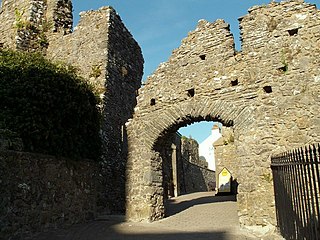
Tenby Castle was a fortification standing on a headland separated by an isthmus from the town of Tenby, Pembrokeshire, Wales. The remaining stone structure dates from the 13th century but there are mentions of the castle from as early as 1153. It is a Grade II* listed building.

The Appian Way Regional Park is the second-largest urban park of Europe, after Losiny Ostrov National Park in Moscow. It is a protected area of around 4580 hectares, established by the Italian region of Latium. It falls primarily within the territory of Rome but parts also extend into the neighbouring towns of Ciampino and Marino.