Related Research Articles

The San Luis Valley is a region in south-central Colorado with a small portion overlapping into New Mexico. The valley is approximately 122 miles (196 km) long and 74 miles (119 km) wide, extending from the Continental Divide on the northwest rim into New Mexico on the south. It contains 6 counties and portions of 3 others. It is an extensive high-elevation depositional basin of approximately 8,000 square miles (21,000 km2) with an average elevation of 7,664 feet (2,336 m) above sea level. The valley is a section of the Rio Grande Rift and is drained to the south by the Rio Grande, which rises in the San Juan Mountains to the west of the valley and flows south into New Mexico. The San Luis Valley has a cold desert climate but has substantial water resources from the Rio Grande and groundwater.
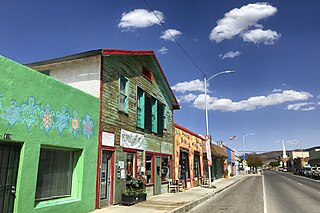
Truth or Consequences is a city in the U.S. state of New Mexico, and the county seat of Sierra County. In 2020, the population was 6,052. It has frequently been noted on lists of unusual place names for having chosen to rename itself in March 1950 after the Truth or Consequences radio show. The name is often hyphenated for clarity, though the formal name contains no punctuation.
Hydrothermal circulation in its most general sense is the circulation of hot water. Hydrothermal circulation occurs most often in the vicinity of sources of heat within the Earth's crust. In general, this occurs near volcanic activity, but can occur in the shallow to mid crust along deeply penetrating fault irregularities or in the deep crust related to the intrusion of granite, or as the result of orogeny or metamorphism. Hydrothermal circulation often results in hydrothermal mineral deposits.

Hot Springs National Park is a national park of the United States in central Garland County, Arkansas, adjacent to the city of Hot Springs. Hot Springs Reservation was initially created by an act of the United States Congress on April 20, 1832, to be preserved for future recreation. Established before the concept of a national park existed, it was the first time that land had been set aside by the federal government to preserve its use as an area for recreation. The hot spring water has been popularly believed for centuries to possess medicinal properties, and was a subject of legend among several Native American tribes. Following federal protection in 1832, the city developed into a successful spa town.

The Sacramento Mountains are a mountain range in the south-central part of the U.S. state of New Mexico, lying just east of Alamogordo in Otero County. From north to south, the Sacramento Mountains extend for 85 miles (137 km), and from east to west they encompass 42 miles (68 km).

The Sierra Blanca is an ultra-prominent range of volcanic mountains in Lincoln and Otero counties in the south-central part of the U.S. state of New Mexico. The range is about 40 miles (64 km) from north to south and 20 miles (32 km) wide.

The Organ Mountains are a rugged mountain range in southern New Mexico in the Southwestern United States. Organ Mountains–Desert Peaks National Monument was declared a national monument on May 21, 2014. They lie 10 mi (16 km) east of the city of Las Cruces, in Doña Ana County.

The Caballo Mountains, are a mountain range located in Sierra and Doña Ana Counties, New Mexico, United States. The range is located east of the Rio Grande and Caballo Lake, and west of the Jornada del Muerto; the south of the range extends into northwest Doña Ana County. The nearest towns are Truth or Consequences and Hatch.
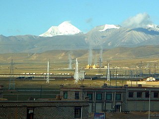
The Yangbajain Geothermal Field (羊八井地热田) is a geothermal field near the town of Yangbajain in Damxung County, Tibet Autonomous Region, China. The fluid is heated by magmatic activity not far below the surface. It is a tourist attraction and also supplies steam to a major power plant with 25 MW capacity.
McRae Canyon originally known as Cañon del Muerto, is a canyon in the southern Fra Cristobal Range in Sierra County, New Mexico. Its waters are tributary to the Rio Grande, and today flow into the Elephant Butte Reservoir at the head of an inlet in the flooded lower canyon, at an elevation of 4,354 feet. Its source is at 33°13′52″N107°05′50″W, at an elevation of 5,070 feet in the southern Fra Cristobal Range.
The geology of Cameroon is almost universally Precambrian metamorphic and igneous basement rock, formed in the Archean as part of the Congo Craton and the Central African Mobile Zone and covered in laterite, recent sediments and soils. Some parts of the country have sequences of sedimentary rocks from the Paleozoic, Mesozoic and Cenozoic as well as volcanic rock produced by the 1600 kilometer Cameroon Volcanic Line, which includes the still-active Mount Cameroon. The country is notable for gold, diamonds and some onshore and offshore oil and gas.

The geology of Arizona began to form in the Precambrian. Igneous and metamorphic crystalline basement rock may have been much older, but was overwritten during the Yavapai and Mazatzal orogenies in the Proterozoic. The Grenville orogeny to the east caused Arizona to fill with sediments, shedding into a shallow sea. Limestone formed in the sea was metamorphosed by mafic intrusions. The Great Unconformity is a famous gap in the stratigraphic record, as Arizona experienced 900 million years of terrestrial conditions, except in isolated basins. The region oscillated between terrestrial and shallow ocean conditions during the Paleozoic as multi-cellular life became common and three major orogenies to the east shed sediments before North America became part of the supercontinent Pangaea. The breakup of Pangaea was accompanied by the subduction of the Farallon Plate, which drove volcanism during the Nevadan orogeny and the Sevier orogeny in the Mesozoic, which covered much of Arizona in volcanic debris and sediments. The Mid-Tertiary ignimbrite flare-up created smaller mountain ranges with extensive ash and lava in the Cenozoic, followed by the sinking of the Farallon slab in the mantle throughout the past 14 million years, which has created the Basin and Range Province. Arizona has extensive mineralization in veins, due to hydrothermal fluids and is notable for copper-gold porphyry, lead, zinc, rare minerals formed from copper enrichment and evaporites among other resources.
Comanche Springs was an aquifer of six artesian springs geographically located between the Edwards Plateau and the Trans-Pecos regions of West Texas. The military fortification Camp Stockton was built around the springs, eventually growing become the city of Fort Stockton.
The geology of Mississippi includes some deep igneous and metamorphic crystalline basement rocks from the Precambrian known only from boreholes in the north, as well as sedimentary sequences from the Paleozoic. The region long experienced shallow marine conditions during the tectonic evolutions of the Mesozoic and Cenozoic, as coastal plain sediments accumulated up to 45,000 feet thick, including limestone, dolomite, marl, anhydrite and sandstone layers, with some oil and gas occurrences and the remnants of Cretaceous volcanic activity in some locations.

The Hot Springs Bathhouse and Commercial Historic District in Truth or Consequences in Truth or Consequences, New Mexico is a 56 acres (23 ha) historic district which was listed on the National Register of Historic Places in 2005.
Cañon del Muerto is a canyon, in Sierra County, New Mexico.

The Santa Fe Group is a group of geologic formations in New Mexico and Colorado. It contains fossils characteristic of the Oligocene through Pleistocene epochs. The group consists of basin-filling sedimentary and volcanic rocks of the Rio Grande rift, and contains important regional aquifers.

The geology of California is highly complex, with numerous mountain ranges, substantial faulting and tectonic activity, rich natural resources and a history of both ancient and comparatively recent intense geological activity. The area formed as a series of small island arcs, deep-ocean sediments and mafic oceanic crust accreted to the western edge of North America, producing a series of deep basins and high mountain ranges.

Truth or Consequences Hot Springs is a thermal spring system located in the Hot Springs Artesian Basin area of Truth or Consequences, New Mexico in Sierra County.

The Geronimo Springs Museum is a small regional museum located in Truth or Consequences, New Mexico. It is named after Geronimo Hot Springs, one of numerous hot springs in the Hot Springs Artesian Basin. The springs were named after the Chiricahua Apache leader Geronimo (1829–1909) from the Bedonkohe band of the Apache people.
References
- 1 2 Theis, Charles V.; Taylor, Jr., George C.; Murray, C. Richard (1941). "Thermal Waters of the Hot Springs Artesian Basin, Sierra County, New Mexico" (PDF). Biennial Reports of the State Engineer of New Mexico. Retrieved 3 January 2022.
- ↑ White, W.E.; Kues, G.E. (1992). "Inventory of Springs in the State of New Mexico" (PDF). USGS Open File Report: New Mexico State Engineers Report. 92 (118). Retrieved 3 January 2022.
- ↑ Roach, Lisa. "The Healing Waters Trail: A Cultural Landscapes Approach to Planning a Semi-Urban Trail System, Truth or Consequences, New Mexico" (PDF). University of New Mexico. Retrieved 3 January 2022.
| | This article about a specific United States geological feature is a stub. You can help Wikipedia by expanding it. |