
The San Luis Valley is a region in south-central Colorado with a small portion overlapping into New Mexico. The valley is approximately 122 miles (196 km) long and 74 miles (119 km) wide, extending from the Continental Divide on the northwest rim into New Mexico on the south. It contains 6 counties and portions of 3 others. It is an extensive high-elevation depositional basin of approximately 8,000 square miles (21,000 km2) with an average elevation of 7,664 feet (2,336 m) above sea level. The valley is a section of the Rio Grande Rift and is drained to the south by the Rio Grande, which rises in the San Juan Mountains to the west of the valley and flows south into New Mexico. The San Luis Valley has a cold desert climate but has substantial water resources from the Rio Grande and groundwater.

The Town of Pagosa Springs is a home rule municipality that is the county seat, the most populous community, and the only incorporated municipality in Archuleta County, Colorado, United States. The population was 1,727 at the 2010 census. Approximately 65 percent of the land in Archuleta County is either San Juan National Forest, Weminuche and South San Juan Wilderness areas, or Southern Ute Indian reservation land.

The Red Rock Canyon National Conservation Area in Clark County, Nevada, is an area managed by the Bureau of Land Management as part of its National Landscape Conservation System, and protected as a National Conservation Area. It is about 15 miles (24 km) west of Las Vegas, and is easily seen from the Las Vegas Strip. More than three million people visit the area each year.

The Imperial Valley of Southern California lies in Imperial and Riverside counties, with an urban area centered on the city of El Centro. The Valley is bordered by the Colorado River to the east and, in part, the Salton Sea to the west. Farther west lies the San Diego and Imperial County border. To the north is the Coachella Valley region of Riverside County, which together with Imperial Valley form the Salton Trough, or the Cahuilla Basin, also the county line of Imperial and Riverside counties, and to the south the international boundary with Mexico.
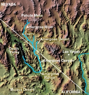
The Amargosa Valley is the valley through which the Amargosa River flows south, in Nye County, southwestern Nevada and Inyo County in the state of California. The south end is alternately called the "Amargosa River Valley'" or the "Tecopa Valley." Its northernmost point is around Beatty, Nevada and southernmost is Tecopa, California, where the Amargosa River enters into the Amargosa Canyon.

Ash Springs is an unincorporated community in the Pahranagat Valley of Lincoln County, Nevada. The community's principal industry is ranching. Ash Springs is named for the desert ash trees growing nearby.

The Wave is a sandstone rock formation located in Arizona, United States, near its northern border with Utah. The formation is situated on the slopes of the Coyote Buttes in the Paria Canyon-Vermilion Cliffs Wilderness of the Colorado Plateau. The area is administered by the Bureau of Land Management (BLM) at the Grand Staircase–Escalante National Monument visitor center in Kanab, Utah.

The Amargosa Desert is located in Nye County in western Nevada, United States, along the California–Nevada border, comprising the northeastern portion of the geographic Amargosa Valley, north of the Ash Meadows National Wildlife Refuge.
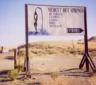
Mercey Hot Springs is an unincorporated community and historical hot springs resort in the Little Panoche Valley of Fresno County, central California, about 60 miles (97 km) west-southwest of Fresno.

The Red Desert is a high-altitude desert and sagebrush steppe located in the south-central portion of the U.S. state of Wyoming, comprising approximately 9,320 square miles. Among the natural features in the Red Desert region are the Great Divide Basin, a unique endorheic drainage basin formed by a division in the Continental Divide, and the Killpecker Sand Dunes, the largest living dune system in the United States. In the 19th century, the Oregon, California, and Mormon Trails crossed the Continental Divide at South Pass, just north of the Red Desert. Today, busy Interstate 80 bisects the desert's southern region while gas field roads cross the desert.

The Lower Colorado River Valley (LCRV) is the river region of the lower Colorado River of the southwestern United States in North America that rises in the Rocky Mountains and has its outlet at the Colorado River Delta in the northern Gulf of California in northwestern Mexico, between the states of Baja California and Sonora. This north–south stretch of the Colorado River forms the border between the U.S. states of California/Arizona and Nevada/Arizona, and between the Mexican states of Baja California/Sonora.

Manby Hot Springs, also known as Stagecoach Hot Springs are thermal springs located near the town of Arroyo Hondo, New Mexico. The springs discharge into three rock pools with sandy bottoms located near the ruins of an old bathhouse and a historical stagecoach stop.

Bartine Hot Springs also known as Bartine Ranch Hot Springs are geothermal hot springs located in the Antelope Valley of the Nevada high desert 40 kilometers northwest of the town of Eureka.
Fish Lake Hot Well, also known as Fish Lake Hot Spring and Fish Lake Valley Hot Well is a geothermal hot spring in Nevada.

Conundrum Hot Springs is a geothermal spring in a remote section of the Maroon Bells-Snowmass Wilderness area of the White River National Forest in Colorado Rocky Mountains.

Soldier Meadows hot spring system is a group of hot and warm springs near the town of Gerlach, Nevada.
Sespe Hot Springs are a system of thermal springs and seeps that form a hot spring creek in the mountains near the Sespe Condor Sanctuary near Ojai, California.

Saline Valley Hot Springs are a series of three thermal springs located in the remote Saline Valley area of Death Valley National Park.
Truth or Consequences Hot Springs is a thermal spring system located in the Hot Springs Artesian Basin area of Truth or Consequences, New Mexico in Sierra County.

Buckhorn Hot Mineral Wells also known as Buckhorn Baths, and Buckhorn Mineral Wells is a hot spring located seven miles East of Mesa, Arizona.
