Related Research Articles

Columbia, also known as Nuna or Hudsonland, was one of Earth's ancient supercontinents. It was first proposed by Rogers & Santosh 2002 and is thought to have existed approximately 2,500 to 1,500 million years ago in the Paleoproterozoic Era. Zhao et al. 2002 proposed that the assembly of the supercontinent Columbia was completed by global-scale collisional events during 2.1–1.8 Ga. Other sources give 1,820–1,350 Ma.

The Grenville orogeny was a long-lived Mesoproterozoic mountain-building event associated with the assembly of the supercontinent Rodinia. Its record is a prominent orogenic belt which spans a significant portion of the North American continent, from Labrador to Mexico, as well as to Scotland.

The Slave Craton is an Archaean craton in the north-western Canadian Shield, in Northwest Territories and Nunavut. The Slave Craton includes the 4.03 Ga-old Acasta Gneiss which is one of the oldest dated rocks on Earth. Covering about 300,000 km2 (120,000 sq mi), it is a relatively small but well-exposed craton dominated by ~2.73–2.63 Ga greenstones and turbidite sequences and ~2.72–2.58 Ga plutonic rocks, with large parts of the craton underlain by older gneiss and granitoid units. The Slave Craton is one of the blocks that compose the Precambrian core of North America, also known as the palaeocontinent Laurentia.
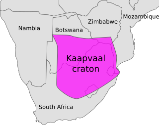
The Kaapvaal Craton, along with the Pilbara Craton of Western Australia, are the only remaining areas of pristine 3.6–2.5 Ga crust on Earth. Similarities of rock records from both these cratons, especially of the overlying late Archean sequences, suggest that they were once part of the Vaalbara supercontinent.

The Churchill Craton is the northwest section of the Canadian Shield and stretches from southern Saskatchewan and Alberta to northern Nunavut. It has a very complex geological history punctuated by at least seven distinct regional tectonometamorphic intervals, including many discrete accretionary magmatic events. The Western Churchill province is the part of the Churchill Craton that is exposed north and west of the Hudson Bay. The Archean Western Churchill province contributes to the complicated and protracted tectonic history of the craton and marks a major change in the behaviour of the Churchill Craton with many remnants of Archean supracrustal and granitoid rocks.
The Trans-Hudson orogeny or Trans-Hudsonian orogeny was the major mountain building event (orogeny) that formed the Precambrian Canadian Shield and the North American Craton, forging the initial North American continent. It gave rise to the Trans-Hudson orogen (THO), or Trans-Hudson Orogen Transect (THOT), which is the largest Paleoproterozoic orogenic belt in the world. It consists of a network of belts that were formed by Proterozoic crustal accretion and the collision of pre-existing Archean continents. The event occurred 2.0–1.8 billion years ago.
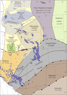
The Wyoming Craton is a craton in the west-central United States and western Canada – more specifically, in Montana, Wyoming, southern Alberta, southern Saskatchewan, and parts of northern Utah. Also called the Wyoming Province, it is the initial core of the continental crust of North America.
The Great Bear Magmatic Zone (GBMZ) is a Paleoproterozoic (1.875–1.86 Ga) multi-collisional orogenic belt of which 100 km × 400 km is exposed in the northwestern Canadian Shield east of Great Bear Lake, Northwest Territories.
The Taltson Magmatic Zone (TMZ) is a north-trending belt of Archean to Paleoproterozoic granitic basement gneiss, amphibolite supracrustal gneissic rock and Paleoproterozoic magmatic rocks in the Canadian Shield, extending from Northern Alberta to the southwestern Northwest Territories. The TMZ basement is 3.2–3.0 Ga and the Rutledge River supracrustal gneisses 2.13–2.09 Ga years old and were intruded by magmatic rocks around 1.99–1.92 Ga.
The Wopmay orogen is a Paleoproterozoic orogenic belt in northern Canada which formed during the collision between the Hottah terrane, a continental magmatic arc, and the Archean Slave Craton at about 1.88 Ga. The collision lead to the short-lived Calderian orogeny. The formation was named for Wilfrid Reid "Wop" May, OBE, DFC, a Canadian flying ace in the First World War and a leading post-war aviator.

The Grouse Creek block is a Precambrian basement province of 2.45 to 2.70 billion year old orthogneisses. The Grouse Creek block is one of several Proterozoic and Archean accreted terranes that lie to the north and west of the Wyoming craton, including the Farmington Canyon Complex, the Selway terrane, the Medicine Hat block and the Priest River complex. Together, these terranes comprise part of the basement rock of the North American continent and have been critical to studies of crustal accretion in the Precambrian. Ongoing study of the Grouse Creek block will contribute to understanding the paleogeography of the Wyoming craton prior to its incorporation into the supercontinent Laurentia approximately 1.86 billion years ago. The name was proposed by David Foster and others.

The Vishnu Basement Rocks is the name recommended for all Early Proterozoic crystalline rocks exposed in the Grand Canyon region. They form the crystalline basement rocks that underlie the Bass Limestone of the Unkar Group of the Grand Canyon Supergroup and the Tapeats Sandstone of the Tonto Group. These basement rocks have also been called either the Vishnu Complex or Vishnu Metamorphic Complex. These Early Proterozoic crystalline rocks consist of metamorphic rocks that are collectively known as the Granite Gorge Metamorphic Suite; sections of the Vishnu Basement Rocks contain Early Paleoproterozoic granite, granitic pegmatite, aplite, and granodiorite that have intruded these metamorphic rocks, and also, intrusive Early Paleoproterozoic ultramafic rocks.

The Svecofennian orogeny is a series of related orogenies that resulted in the formation of much of the continental crust in what is today Sweden and Finland plus some minor parts of Russia. The orogenies lasted from about 2000 to 1800 million years ago during the Paleoproterozoic Era. The resulting orogen is known as the Svecofennian orogen or Svecofennides. To the west and southwest the Svecofennian orogen limits with the generally younger Transscandinavian Igneous Belt. It is assumed that the westernmost fringes of the Svecofennian orogen have been reworked by the Sveconorwegian orogeny just as the western parts of the Transscandinavian Igneous Belt has. The Svecofennian orogeny involved the accretion of numerous island arcs in such manner that the pre-existing craton grew with this new material from what is today northeast to the southwest. The accretion of the island arcs was also related to two other processes that occurred in the same period; the formation of magma that then cooled to form igneous rocks and the metamorphism of rocks.
The Hearne Craton is a craton in northern Canada which, together with the Rae Craton, forms the Western Churchill Province. Hearne is one of the six Archaean cratons of the Canadian Shield that are bound together by Palaeoproterozoic orogenic belts. Before being merged these six cratons formed independent microcontinents.

The Aravalli Mountain Range is a northeast-southwest trending orogenic belt in the northwest part of India and is part of the Indian Shield that was formed from a series of cratonic collisions. The Aravalli Mountains consist of the Aravalli and Delhi fold belts, and are collectively known as the Aravalli-Delhi orogenic belt. The whole mountain range is about 700 km long. Unlike the much younger Himalayan section nearby, the Aravalli Mountains are much older that can be traced back to the Proterozoic Eon. The collision between the Bundelkhand craton and the Marwar craton is believed to be the primary mechanism for the development of the mountain range.
The Grenville Province is a tectonically complex region, in Eastern Canada, that contains many different aged accreted terranes from various origins. It exists southeast of the Grenville Front and extends from Labrador southwestern to Lake Huron. It is bounded by the St. Lawrence River/Seaway to the southeast.

The Eastern Block of the North China Craton is one of the Earth's oldest pieces of continent. It is separated from the Western Block by the Trans-North China Orogen. It is situated in northeastern China and North Korea. The Block contains rock exposures older than 2.5 billion years. It serves as an ideal place to study how the crust was formed in the past and the related tectonic settings.

The Western Block of the North China Craton is an ancient micro-continental block mainly composed of Neoarchean and Paleoproterozoic rock basement, with some parts overlain by Cambrian to Cenozoic volcanic and sedimentary rocks. It is one of two sub-blocks within the North China Craton, located in east-central China. The boundaries of the Western Block are slightly different among distinct models, but the shapes and areas are similar. There is a broad consensus that the Western Block covers a large part of the east-central China.
The Superior Craton is a stable crustal block covering Quebec, Ontario, and southeast Manitoba in Canada, and northern Minnesota in the United States. It is the biggest craton among those formed during the Archean period. A craton is a large part of the Earth's crust that has been stable and subjected to very little geological changes over a long time. The size of Superior Craton is about 1,572,000 km2. The craton underwent a series of events from 4.3 to 2.57 Ga. These events included the growth, drifting and deformation of both oceanic and continental crusts.
The Yavapai orogeny was an orogenic event in what is now the Southwestern United States from 1710 to 1680 Mya in the Statherian Period of the Paleoproterozoic. Preserved in the rocks of New Mexico and Arizona, it is interpreted as the collision of the 1800-1700 Mya age Yavapai island arc terrane with the proto-North American continent. This was the first in a series of orogenies within a long-lived convergent boundary along southern Laurentia that ended with the ca. 1200–1000 Mya Grenville orogeny during the final assembly of the supercontinent Rodinia, which ended an 800-million-year episode of convergent boundary tectonism.
References
Notes
- ↑ Hildebrand & Bowring 1984 , Great Bear Magmatic Zone, pp. 73–74
- ↑ Ootes et al. 2015 , Geological Setting
- ↑ Hildebrand, R.S. (1981). in Campbell, F.H.A. (ed.). Proterozoic Basins: Early Proterozoic LaBine Group of Wopmay orogen: remnant of a continental volcanic arc developed during oblique convergence. Geological Survey of Canada Paper 81-10. pp. 133–156.
- ↑ Hildebrand, R. S.; Hoffman, P. F.; Bowring, S. A. (1987). "Tectonomagmatic evolution of the 1.9 Ga Great Bear magmatic zone, Wopmay orogen, northwestern Canada". Journal of Volcanology and Geothermal Research. 32 (1–3): 99–118. doi:10.1016/0377-0273(87)90039-4.
- ↑ Ootes et al. 2015 , Abstract
Sources
- Gandhi, S. S.; Breemen, O. V. (2005). "SHRIMP U Pb geochronology of detrital zircons from the Treasure Lake Group new evidence for Paleoproterozoic collisional tectonics in the southern Hottah terrane, northwestern Canadian Shield". Canadian Journal of Earth Sciences. 42 (5): 833–845. doi:10.1139/e05-021.
- Hildebrand, R. S.; Bowring, S. A. (1984). "Continental intra-arc depressions: A nonextensional model for their origin, with a Proterozoic example from Wopmay orogen" (PDF). Geology. 12 (2): 73–77. doi:10.1130/0091-7613(1984)12<73:CIDANM>2.0.CO;2 . Retrieved 6 June 2016.
- Ootes, L.; Davis, W. J.; Jackson, V. A.; van Breemen, O. (2015). "Chronostratigraphy of the Hottah terrane and Great Bear magmatic zone of Wopmay Orogen, Canada, and exploration of a terrane translation model" (PDF). Canadian Journal of Earth Sciences. 52 (12): 1062–1092. doi: 10.1139/cjes-2015-0026 . Retrieved 6 June 2016.