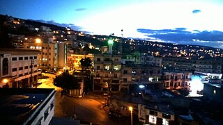
Miniara is a village in Akkar Governorate, Lebanon, 9 kilometers east of the Mediterranean Sea, and 3 kilometers south of Halba. The population is between 7,000 and 10,000.

Halba is the capital of Akkar Governorate in northern Lebanon, close to the border with Syria. It is located at around 34°33′2″N36°4′41″E. Its population is divided between Sunni Muslim, Greek Orthodox Christians, Maronites, and followers of other religions.
Cheikh Mohammad is a village situated in Akkar Governorate, Lebanon. Situated 400 metres above sea level, in between two mountains, it overlooks the Akkar plains and sea. It is made up of approximately 450 houses, with 99% of the population being Christian, mostly Greek Orthodox, Melkite Catholics and Maronites. This small village contains two schools, a primary and secondary as well as two churches, one dating back hundreds of years. It also has the first hospital in Akkar, named "Akkar Rahal Hospital".
Fnaidek, Fnaydeq, is a village in Akkar Governorate, Lebanon. Its inhabitants are Sunni Muslims.
Bebnine is a town located in the Akkar District of the Akkar Governorate in Lebanon. Its inhabitants are primarily Sunni Muslims.
Cheikh Taba is a town in Akkar Governorate, Lebanon, close to the border with Syria.
Sayssouq is a village in Akkar Governorate, Lebanon.
Ain Yaaqoub is a village in Akkar Governorate, Lebanon.
Tikrit, also spelled Tekrit, is a town in Akkar Governorate, Lebanon.
Houaich is a town in Akkar Governorate, Lebanon.
Kroum Aarab is a village in Akkar Governorate, Lebanon.

Khreibet Ej Jindi is a town in Akkar Governorate, Lebanon.
Haytla is a town in Akkar Governorate, Lebanon.
Hayzouq is a town in Akkar Governorate, Lebanon.

Machha is a town in Akkar Governorate, Lebanon. Its population comprises mostly Sunni Muslims.
Mar Touma is a village in Akkar Governorate, Lebanon.
Daoura (Aakkar) (Arabic: دورة) (also Daouret) is a town in Akkar Governorate, Lebanon.
Tachaa, also spelled Tasha, is a town in Akkar Governorate, Lebanon.
Aamaret El Baykat is a village in Akkar Governorate, Lebanon.
Koucha is a village in Akkar Governorate, Lebanon.


