Nazca is a city and system of valleys on the southern coast of Peru. The city of Nazca is the largest in the Nazca Province. The name is derived from the Nazca culture, which flourished in the area between 100 BC and AD 800. This culture was responsible for the Nazca Lines and the ceremonial city of Cahuachi. They also constructed additional underground aqueducts, named puquios, in a regional system that still functions today. The first puquios are believed to have been built by the preceding Paracas culture.

Moyobamba or Muyupampa is the capital city of the San Martín Region in northern Peru. Called "Santiago of eight valleys of Moyobamba" or "Maynas capital". There are 50,073 inhabitants, according to the 2017 census. Some 3,500 species of orchids are native to the area, which has led to the city's nickname of The City of Orchids. The city is the capital of both Moyobamba Province and Moyobamba District.
Huacho is a city in Peru, capital of the Huaura Province and capital of the Lima Region. Also is the most populated city of the Lima Region and Norte Chico. It is located 223 feet above sea level and 148 km north of the city of Lima. The city is located on the Pan-American Highway and it is close to the Lachay National Reserve, so it has extensive vegetation and wildlife.
The Department of Lima, known as the Department of the Capital until 1823, is a department and region located in the central coast of Peru; the seat of the regional government is Huacho.

Monsefú is a town in Northern Peru, capital of the Monsefú district in the Chiclayo Province that is part of the Lambayeque Region. It is renowned for its food and handicrafts, which are on display at the annual FEXTICUM festival, named in 1973 by Professor Limberg Chero Ballena and held in July during Fiestas Patrias. Monsefú is also the home of cumbia groups Grupo 5 and Hermanos Yaipen. Monsefú was elevated to the category of "city" on October 26, 1888.
Moquegua is a city in southern Peru, located in the Department of Moquegua, of which it is the capital. It is also capital of Mariscal Nieto Province and Moquegua District. It is located 1144 kilometers south of the capital city of Lima.

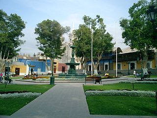
San Vicente de Cañete, commonly known as San Vicente or Cañete, is a city and capital of the Cañete Province, in southern Lima Region. With a population of 85,533.

Huánuco is a city in central Peru. It had a population of 196,627 as of 2017 and in 2015 it had a population of 175,068. It is the capital of the Huánuco Region and the Huánuco District. It is the seat of the diocese of Huánuco. The metropolitan city of Huanuco is 170,000 hab. It has three districts, Huanuco (head), Amarilis, and Pillco Marca. In this city, the Higueras river meets the Huallaga river, one of the largest rivers in the country.

Chachapoyas is a city in northern Peru at an elevation of 2,335 meters (7,661 ft). The city has a population of 32,026 people (2017). Situated in the mountains far from the Peruvian coast, Chachapoyas remains fairly isolated from other regions of Peru. It is served by buses to Chiclayo and Cajamarca, and flights to domestic locations from Chachapoyas Airport.

Yurimaguas is a port town in the Loreto Region of the northeastern Peruvian Amazon. Historically associated with the Mainas missions, the culturally diverse town is affectionately known as the "Pearl of the Huallaga". Yurimaguas is located at the confluence of the majestic Huallaga and Paranapura Rivers in the steamy rainforests of northeastern Peru. It is the capital of both Alto Amazonas Province and Yurimaguas District, and had a population estimated at 62,903 inhabitants (2017).
Chincha Alta is a Peruvian city located in the Ica Region. A major port at the mouth of the Chincha River, it is the capital of Chincha Province. The city has a population of about 233,000, making it the 17th largest city in Peru.

The Huaral Province is one of the nine provinces in the Lima Region of Peru. It was created by Law No. 21488 on May 11, 1976 by president Francisco Morales Bermúdez out of eight districts of the Canta Province and four of the Huaura Province. Geographically, its territory extends around the valley of the Chancay River from the mountainous frontier of the Pasco Region and Junín Region up to the Pacific Ocean.
Chancay District is one of twelve districts of the province Huaral in Peru.
San Miguel de Acos District is one of twelve districts of the province Huaral in Peru.

Huanta is a town in Central Peru, capital of the province Huanta in the region Ayacucho.
Chancay is a small city located 78 km (48 mi) north of Lima. Its population is 63,378. The Chancay culture was a pre-Columbian archaeological culture, later part of the Inca Empire.

Chepén is a city of La Libertad Region and capital of the Chepén Province, in Peru. The city is a rice production center with the valleys of Chepén and Jequetepeque, and has an active trading with neighboring Guadalupe, Pacasmayo and San Pedro de Lloc and other towns. It has factories in industrial dyes, food and primary production.

Laredo is the city capital of Laredo District located 9 km from Trujillo, in La Libertad Region, Peru.