This article needs additional citations for verification .(March 2017) |
Huaura | |
|---|---|
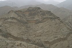 The archaeological site of Acaray | |
 Flag  Coat of arms | |
 Location of Huaura in Lima | |
| Country | Peru |
| Department | Lima |
| Capital | Huacho |
| Government | |
| • Mayor | Crispulo Eddie Jara Salazar (2019-2022) |
| Area | |
• Total | 4,891.92 km2 (1,888.78 sq mi) |
| Population | |
• Total | 227,685 |
| • Density | 46.5431/km2 (120.546/sq mi) |
| UBIGEO | 1501 |
Huaura is a province of the department of Lima, Peru. From the administrative point of view of the Catholic Church in Peru, it forms part of the Diocese of Huacho. Located on the Pacific coast of the country, it has a population of about 180,000 inhabitants. It is bordered by the province of Barranca and the Ancash Region in the north, the provinces of Cajatambo and Oyón and the Pasco Region in the east, the province of Huaral in the south and the Pacific Ocean in the west. Huacho is the capital of the province as well as the Regional Government of Lima.