San Miguel, Spanish for Saint Michael, may refer to:
Tepalcingo is a town in the Mexican state of Morelos. It at 18°26′N98°18′W. The name Nahuatl root tekpa-tl (flint), tzintli, tzinco, so in sum it means tekpatzinko "down or behind the flints".
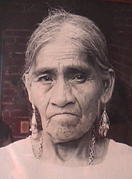
María Sabina was a Mazatec curandera who lived in the Sierra Mazateca of southern Mexico. Her practice was based on the use of psilocybin mushrooms, such as Psilocybe mexicana.
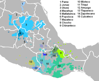
The Mazatecan languages are a group of closely related indigenous languages spoken by some 200,000 people in the area known as the Sierra Mazateca, which is in the northern part of the state of Oaxaca in southern Mexico, as well as in adjacent areas of the states of Puebla and Veracruz.
Municipalities are the second-level administrative divisions of Mexico, where the first-level administrative division is the state. As of the establishment of two new municipalities in Chiapas in September 2017, there are 2,448 municipalities in Mexico, not including the 16 delegaciones of Mexico City. The internal political organization and their responsibilities are outlined in the 115th article of the 1917 Constitution and detailed in the constitutions of the states to which they belong.
Huautla could mean any of the following towns and cities in Mexico:

The Sierra Madre de Oaxaca is a mountain range in southern Mexico. It is primarily in the state of Oaxaca, and extends north into the states of Puebla and Veracruz.

Huautla de Jimenez is a town and municipality in the Mexican state of Oaxaca. It is part of the Teotitlán District in the north of the Cañada Region.
Jiménez or Jimenez may refer to:
Pilcaya is one of the 81 municipalities of Guerrero, in south-western Mexico. The municipal seat lies at Pilcaya. The municipality covers an area of 62.1 km².
Huautepec is a town and municipality in Oaxaca in south-western Mexico. The municipality covers an area of 35.72km². It is part of the Teotitlán District in the north of the Cañada Region.As of 2005, the municipality had a total population of 5,672.
Mazatlán Villa de Flores is a town and municipality in Oaxaca in south-western Mexico. It is part of the Teotitlán District in the north of the Cañada Region.
San Miguel Huautla is a town and municipality in Oaxaca in south-western Mexico. The municipality covers an area of 111 km². It is part of the Nochixtlán District in the southeast of the Mixteca Region.

Cañada is a region in the state of Oaxaca, Mexico covering 4,300 square km. It includes two districts, Teotitlán and Cuicatlán. The main administrative center is Teotitlán de Flores Magón, but Huautla de Jiménez is considered the most important cultural center in the region.
Teotitlán District is located in the north of the Cañada Region of the State of Oaxaca, Mexico.
Nochixtlán District is located in the southeast of the Mixteca Region of the State of Oaxaca, Mexico. The main city is Asunción Nochixtlán.
Tecóatl Mazatec, also known as Eloxochitlán Mazatec and Northern Highland Mazatec, is a Mazatecan language spoken in the Mexican states of Oaxaca and Puebla, notably in the towns of San Jerónimo Tecóatl, Eloxochitlán de Flores Magón, San Lucas Zoquiapam, Santa Cruz Acatepec, San Pedro Ocopetatillo, San Lorenzo Cuaunecuiltitla, Santa Ana Ateixtlahuaca, and San Francisco Huehuetlán. Egland found 76% intelligibility with Huautla, the prestige variety of Mazatec, though SIL reports that speakers of all dialects "have considerable difficulty understanding the prestigious variant spoken in Huautla de Jiménez"

Charles William Steele, Jr., known as “Bill Steele,” is a cave explorer. He is a speleologist who has led and participated in expeditions to many of the longest and deepest caves in the USA, Mexico, and China. He has explored more than 2,500 caves across North America and Asia and has written two books chronicling his expeditions: "Yochib: The River Cave", and "Huautla: Thirty Years in One of the World's Deepest Caves.” TV shows such as National Geographic Explorer, NOVA and How’d They Do That? have aired programs on his expeditions.
Sistema Huautla is a cave system in the Sierra Mazateca mountains of the southern Mexican state of Oaxaca. As of 2013 it was the deepest cave system in the Western Hemisphere, 5069 feet from top to bottom, with over 40 miles of mapped passageways. By May 2018 the most recent report reported it as 53 miles long with 25 distinct entrances and a depth measurement of 5,118 feet from its highest known entrance to its lowest reached point, System Huautla is the deepest cave in the Western Hemisphere and the ninth deepest cave in the world; it is listed as the second longest at about 215 miles available tunnels compared to the Mammoth Cave complex at 405+ miles.


