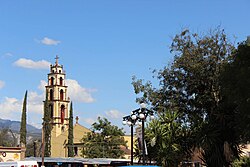
Tasquillo Maxei | |
---|---|
Municipality and Town | |
Coordinates: 20°37′N99°15′W / 20.617°N 99.250°W | |
Country | Mexico |
State | Hidalgo |
Municipality | Tasquillo |
Government | |
• Municipal President | Alberto Basilio González |
Area | |
• Municipality and Town | 240 km2 (90 sq mi) |
Elevation | 1,631 m (5,351 ft) |
Population (2020) | |
• Municipality and Town | 17,451 |
• Density | 72/km2 (190/sq mi) |
• Rural | 13,421 |
Demonym(s) | Tasquillense Taquillano |
Time zone | Central (US Central) |
Tasquillo (Otomi: Maxei) is a town and one of the 84 municipalities of Hidalgo, in central-eastern Mexico. it is located km 5 from the Mexican Federal Highway 45 and km 10 from the nearby city of Ixmiquilpan in the central west part of the state of Hidalgo.
It has not been possible to clarify whether the word Tasquillo is of origin Otomí or Nahuatl. [1]
Tasquillo was populated by a few ethnic groups which were the Nahuas, Toltecs and especially the Otomí groups who have given the name “Mashei ” to the place. [2] Among the most important historical events are the discoveries of curious junk, metals, carved stones or sticks and tools of men who were buried in clay pots. It is said that these relics are found in the Huemac . [1]
in the 15th century under the domination of the Mexica culture it was named Taxco. Later, with the Spanish conquest in the 16th century, it was given the name “town of the natives of San Bernardino,” subject to a commission from the Marquis of Zúñiga. [2] and during this time the Spaniards settled at a point called Donijá, which is located southeast of the main square. [3]
in the 17th century it was given the name of Taxquillo, a word composed from Nahuatl or Otomi. In Nahuatl the word comes from the game of tlachtli which means "ball game", In its Otomi dialect the meaning would be "Place of Goats", in Spanish the word of illo means diminutive or small, which gives it another meaning "Small place of the game of ball" or "Small place of goats". [2] [4] [1]
According to what is known by the mayoralties, in the 18th century it was not considered among the towns to citizens due to its lack of importance and poverty-rate, since it was simply a neighborhood and municipal seat of the town-hall of Ixmiquilpan. [5] [3] [1]
The constitution of the municipality of Tasquillo [3] is achieved as a town hall belonging to the Huichapan district of the Tula prefecture on the 15th of February 1826.
in 1861 to 1869, Tasquillo is recorded as a municipality forming part from the Zimapán district of the State of Mexico and eventually becoming a municipality of the Ixmiquilpan district belonging to the Tula department of the State of Mexico. Once the State of Hidalgo was established in 1869, Tasqullio was designated as the head of the Municipality of its name for the Zimapan District, And until 1920 Tasquillo was recorded as a free municipality. [1]
In 1983 The name of the municipality of Tasquillo is modified replacing Taxqullio. [1]
Municipal President María de Jesús Chávez (PRI) died of COVID-19 on January 30, 2021. She took office on December 15, 2020. [6]
The Cerro Juarez peak has an elevation of 3,041.29 m (9,978 ft). [7] located in the geographic region of the Mezquital Valley.
The Tula River, a tributary from the Moctezuma River that flows to Zimapan towards the city of Ixmiquilpan, the river passes in-between Cerro Juarez and the town. [8]
Climate data for Tasquillo | |||||||||||||
---|---|---|---|---|---|---|---|---|---|---|---|---|---|
Month | Jan | Feb | Mar | Apr | May | Jun | Jul | Aug | Sep | Oct | Nov | Dec | Year |
Record high °C (°F) | 35.0 (95.0) | 34.0 (93.2) | 37.0 (98.6) | 38.0 (100.4) | 37.0 (98.6) | 37.0 (98.6) | 35.0 (95.0) | 35.0 (95.0) | 34.0 (93.2) | 32.0 (89.6) | 34.0 (93.2) | 34.0 (93.2) | 38.0 (100.4) |
Mean daily maximum °C (°F) | 25.7 (78.3) | 26.7 (80.1) | 28.3 (82.9) | 29.5 (85.1) | 30.4 (86.7) | 29.6 (85.3) | 28.9 (84.0) | 28.9 (84.0) | 28 (82) | 27.2 (81.0) | 26.3 (79.3) | 25.7 (78.3) | 27.9 (82.2) |
Daily mean °C (°F) | 15.9 (60.6) | 16.8 (62.2) | 18.7 (65.7) | 19.9 (67.8) | 20.9 (69.6) | 20.6 (69.1) | 20.2 (68.4) | 20.1 (68.2) | 19.4 (66.9) | 18.5 (65.3) | 17.1 (62.8) | 16.2 (61.2) | 18.7 (65.7) |
Mean daily minimum °C (°F) | 6.1 (43.0) | 7.1 (44.8) | 9.1 (48.4) | 10.4 (50.7) | 11.3 (52.3) | 11.7 (53.1) | 11.5 (52.7) | 11.3 (52.3) | 10.9 (51.6) | 9.7 (49.5) | 7.9 (46.2) | 6.6 (43.9) | 9.5 (49.1) |
Record low °C (°F) | 0 (32) | 1 (34) | 3 (37) | 5 (41) | 1 (34) | 4 (39) | 7 (45) | 7 (45) | 7 (45) | 2 (36) | 0 (32) | 0 (32) | 0 (32) |
Average precipitation mm (inches) | 6.9 (0.27) | 8.5 (0.33) | 11 (0.4) | 13 (0.5) | 29.4 (1.16) | 52.4 (2.06) | 59.4 (2.34) | 43.4 (1.71) | 53.4 (2.10) | 36 (1.4) | 8.1 (0.32) | 2.5 (0.10) | 324 (12.8) |
Average precipitation days (≥ 0.1 mm) | 1.1 | 0.9 | 1.2 | 1.5 | 3.3 | 4.8 | 4.4 | 3.4 | 4 | 3.3 | 1 | 0.4 | 29.3 |
Source: Servicio Meteorologico Nacional [9] |
Tasquillo covers an area of 167 km2 with the town having a population of only 4,030 as of 2020. [10]
The Parroquia of San Bernardino de Siena is a church located in the center of the town. Which was founded in 1560 and dedicated to the Italian saint Bernardino of Siena. The church has baroque style architecture and is located in the center of the city. The parish is known for its annual festival in honor of San Bernardino of Siena, which is celebrated on May 20. [11]
The Municipality itself has an area of 240.01 km within the Mezquital Valley with the municipality having a total population of 17,451 as of 2020. [12] It borders with the municipalities of Tecozautla, Zimapán, Ixmiquilpan, Alfajayucan, Alfajayucan and Tecozautla.
Year | Pop. | ±% |
---|---|---|
1900 | 874 | — |
1967 | 10,245 | +1072.2% |
1995 | 16,926 | +65.2% |
2000 | 16,648 | −1.6% |
2005 | 15,429 | −7.3% |
2010 | 16,865 | +9.3% |
2020 | 17,451 | +3.5% |
Tula de Allende is a town and one of the 84 municipalities of Hidalgo in central-eastern Mexico. The municipality covers an area of 305.8 km2 (118.07 sq mi), and as of 2010, the municipality had a total population of 103,919. The municipality includes numerous smaller outlying towns, the largest of which are El Llano, San Marcos, and San Miguel Vindho. It is a regional economic center and one of Mexico's fastest growing cities. However, it is best known as the home of the Tula archeological site, noted for its Atlantean figures. Its built-up area made up of Atotonilco de Tula, Atitalaquia, Tlaxcoapan municipalities was home to 188,659 inhabitants at the 2010 census.
Hidalgo, officially the Free and Sovereign State of Hidalgo, is one of the 31 states which, along with Mexico City, constitute the 32 federal entities of Mexico. It is divided into 84 municipalities and its capital city is Pachuca de Soto. It is located in east-central Mexico and is bordered by San Luis Potosí and Veracruz on the north, Puebla on the east, Tlaxcala and State of Mexico on the south and Querétaro on the west.
Actopan is one of the 84 municipalities of Hidalgo, in central-eastern Mexico, whose municipal seat and most populated locality is Actopan. This municipality covers an area of 280.1 km2. It is crossed by the federal road that runs from Mexico City to Nuevo Laredo and it is located 30 km northwest of Pachuca, the capital city of the state of Hidalgo.
Ixmiquilpan is a city and one of the 84 municipalities of Hidalgo, in central-eastern Mexico. It is located on the Mexico City/Nuevo Laredo Highway at km 170 in the central west part of the state of Hidalgo. The town of Ixmiquilpan is noted for its parish church, Church of San Miguel Arcángel, which contains a large series of murals done in the 16th century by native artists depicting Eagle and Jaguar warriors in battle, along with other pre-Hispanic imagery.
Tequixquiac is a municipality located in the Zumpango Region of the State of Mexico in Mexico. The municipality is located 84 kilometres (52 mi) north of Mexico City within the valley that connects the Valley of Mexico with the Mezquital Valley. The name comes from Nahuatl and means "place of tequesquite waters". The municipal seat is the town of Santiago Tequixquiac, although both the town and municipality are commonly referred to as simply "Tequixquiac".
Huehuetoca is a municipio (municipality) in State of Mexico, central Mexico, and also the name of its largest town and municipal seat.
Alfajayucan is a town and one of the 84 municipalities of Hidalgo, in central-eastern Mexico. The municipal seat lies at Alfajayucan. The municipality covers an area of 467.7 km².
Atotonilco de Tula is one of the 84 municipalities of Hidalgo. It is located in the southwestern part of the state of Hidalgo in Mexico. The municipal seat is Atotonilco de Tula. The municipality is located at a southern pass leading out of the Mezquital Valley to 86 kilometers north of Mexico City and about 180 km northeast of the state capital of Pachuca de Soto. The name comes from Nahuatl and means "place of hot springs" and otomi language is Padehe. The municipality covers an area of 31 km².
Tecozautla is a town and one of the 84 municipalities of Hidalgo, in central-eastern Mexico. The municipality covers an area of 575.6 km2. The name derives from the Nahuatl words "tetl", meaning "stone"; "cozaqui", meaning "yellow thing"; and "tla", meaning "place of"; making the entire meaning of Tecozautla "place where yellow earth abounds".
Zimapán is a town and one of the 84 municipalities of Hidalgo, in central-eastern Mexico. The municipality covers an area of 860.9 km2 (332.4 sq mi).
Apaxco is a municipality located in the Zumpango Region in Mexico. The municipal territory is located at a southern pass leading out of the Mezquital Valley about 288 km (179 mi) northeast of the state capital of Toluca. The name Apaxco comes from Nahuatl.
Villa del Carbón is a municipality located in the northern part of Mexico State, just northwest of Mexico City. While the town and municipal seat of Villa del Carbón is the largest in the municipality, it is not the oldest. The municipality contains a number of villages of Otomí and Nahua origins, in which much of the indigenous culture still survives. The municipality's territory was defined in 1714 when a region known as Chiapan, split into what is now Chapa de Mota and Villa del Carbón. At that time, however, the community which is now a municipal seat did not have an official name; it was known first only by the name of its church Nuestra Señora de la Peña de Francia, and later by being a major supplier of charcoal. This would lead to the name of Villanueva del Carbón de Nuestra Señora Santa María de la Peña de Francia, which eventually shortened to Villa del Carbón. The major portions of the municipality's glyph, which serves as it coat-of-arms, does not reflect the town of Villa del Carbón but rather two of its oldest communities: Taxhimay and San Lorenzo Pueblo Nuevo.
Huexotla or Huexotla is an archaeological site located 5 kilometers south of Texcoco, at the town of San Luis Huexotla, close to Chapingo, in the state of Mexico.
The Mezquital Valley is a series of small valleys and flat areas located in Central Mexico, about 60 kilometres (37 mi) north of Mexico City, located in the western part of the state of Hidalgo. It is part of the Trans-Mexican Volcanic Belt, with altitudes between 1,700 metres (5,600 ft) and 2,100 metres (6,900 ft) above sea level. It is one of Mexico's main semi-arid/area regions, whose native vegetation is dominated by cactus species, mesquite trees, and maguey with pine and oak trees in the highest elevations. It is considered to be part of the northern extension of Mesoamerica, with one major archeological site, Tula, which was the main city of the Toltecs, an important influence for the later Aztecs. However, from the Aztec period to the 20th century, it was sparsely populated and very poor, with one main indigenous ethnicity, the Otomis. In the 20th century, irrigation works were created to take advantage of the water in the Tula River, along with wastewater drained from the Valley of Mexico for agriculture. Today, the valley produces various grains and produce, including one-quarter of all green chili peppers grown in Mexico.
Zumpango is a region, located in the north of the State of Mexico in the country of the same name. It is also known as the Region XVI Zumpango and has seen major population growth. It has a surface area of 8.305 km2 and occupies 12.8% of the state's territory. The seat of Zumpango Region is Zumpango de Ocampo city.
Hidalgo (state) handcrafts and folk art are mostly made for local consumption rather than for collectors, although there have been efforts to promote this work to a wider market. Most are utilitarian and generally simply decorated, if decorated at all. The most important handcraft traditions are pottery, especially in the municipality of Huejutla and textiles, which can be found in diverse parts of the state. Most artisans are indigenous, with the Otomi populations of the Mezquital Valley being the most dominant. Other important handcrafts include basketry, metal and wood working.
Teotlalpan was the pre-Columbian name of a region in the north of Valley of Mexico comprising what is today the Mezquital Valley in the state of Hidalgo and adjacent areas in the State of Mexico. The region was one of two regions settled by Otomí people, the other being the region around Jilotepec and Tula, Hidalgo. In the 18th century the name of the main part of the region came to be known as Mezquital.
The 2021 Tula River floods were a natural disaster caused by the overflow of the Tula River and several of its tributaries, affecting different municipalities in the Mezquital Valley in Hidalgo, Mexico.
El Mandho is a town in Mexico located in the municipality of Ixmiquilpan in the state of Hidalgo.
The second federal electoral district of Hidalgo is one of the 300 electoral districts into which Mexico is divided for elections to the federal Chamber of Deputies and one of the seven currently operational districts in the state of Hidalgo.