Pachuca Municipality

Last updated
Pachuca
Escudo de Pachuca de Soto.svg
Coat of arms
Mexico Hidalgo Pachuca location map.svg
Country Mexico
State Hidalgo
Municipal seat Pachuca de Soto
Government
   Municipal President Eleazar García Sánchez
Population
  Total267 862 [1]
Time zone UTC-6 (CST)
  Summer (DST) UTC-5 (CDT)

The Municipality of Pachuca de Soto, or Municipality of Pachuca, is one of the Municipalities of the state of Hidalgo, located in east-central Mexico.

Contents

The municipal seat is the City of Pachuca de Soto (Ciudad de Pachuca de Soto). The Municipality of Pachuca is increasingly co-extensive with the metropolitan area of Pachuca, as development has grown to cover over 60% of the geographic open space. That has eliminated much of the municipality's native flora diversity and larger fauna.

Geography

Panorama of Pachuca city and municipality. Pachucapanoramica.jpg
Panorama of Pachuca city and municipality.
Pachuca-Tizayuca Valley,
in the Municipality of Pachuca. Vallepachuca.jpg
Pachuca-Tizayuca Valley,
in the Municipality of Pachuca.

The location of the municipality is north of the state of Mexico, and is located in the low extreme geographical coordinates of Greenwich, north latitude 20º01'23", 20º12'28" maximum, west longitude 98°41'30" minimum, 98°52'35" maximum. [2] The Municipality of Pachuca has a territory of 195,300 square kilometres (75,400 sq mi) and borders the municipalities of Mineral del Chico, Mineral del Monte, Zempoala, Zapotlán de Juárez, Mineral de la Reforma, Epazoyucan, and San Agustín Tlaxiaca.

Natural features

The municipality is located in rugged hill and mountain terrains, and varies in altitude between 2,400–2,800 metres (7,900–9,200 ft) above sea level. [3] [4] It is located on the Trans-Mexican Volcanic Belt (Eje Volcánico Transversal, Sierra Nevada) mountain ranges system. The only major level terrain is where the historic center of Pachuca city is located. Notable mountains are the Cerro del Cuixi, the Cerro de San Cristóbal, and the Cerro de Cubitos.

Rivers that cross through the municipality are the Actopan, the Amajac and the Tezontepec Rivers. The climate is temperate and relatively cold with strong winds during eight to nine months out of the year. These can reach speeds of 60–65 km an hour. [4]

Economy

64% of the Municipality of Pachuca is a developed urban area. Agriculture is nearly a non-existent factor in the economy, as the small-scale farming and livestock raising in the hills is for family or local consumption.[ citation needed ]

Industry

Despite its decline in the 20th century, mining still continues to be an important element of Pachuca's economy. Pachuca still produces more than 60% of the state's gold and more than 50% of its silver.

The manufacturing sector was established in the 1950s and has been steadily growing, changing the city's traditional mining image. Some of the major industrial employers are Applied Power de México (automotive parts), BARROMEX (machinery), Herramientas Cleveland (machinery and tools) and Embotelladora la Minera (soft drinks). The city also contains over 800 smaller manufacturing enterprises.

The municipality's economy also has a large commercial sector, with numerous stores and thirteen public markets. It is also the wholesale center for foodstuffs for most of the state.

Tourism

Despite all the changes in the 20th century, the Historic center of Pachuca has maintained its colonial provincial feel. This has led the municipality and city to promote it as a tourist attraction. [4] [5]

The Mina de Acosta is a mine, and an open-air and subterranean mining museum, adjacent to Pachuca in the village of Real del Monte in the municipality. It is still active, but barely as for each ton and a half of ore extracted, only 200 grams of silver and 2 grams of gold are obtained. Guided tours show how ore is extracted from the mine, at depths up to 500 metres (1,600 ft).

Politics

Demography

According to the 2005 census the Municipality of Pachuca de Soto had 275,578 inhabitants. The municipality contains fifteen other communities, with all but two having less than 1,500 people according to the 2005 INEGI census.

Only three percent of the municipality's population lives outside the Pachuca city boundaries. [3] The majority of the residents are Roman Catholic, but there is a significant percentage of Protestants, mostly descendants of English miners. [4]

Populated places in Pachuca

TownPopulation
Total267,862 [6]
Pachuca de Soto 256,584
Santiago Tlapacoya 3362
San Miguel Cerezo 1981
El Huixmí 2567

Settlements in the Municipality of Pachuca include:

See also

Related Research Articles

Hidalgo (state) State of Mexico

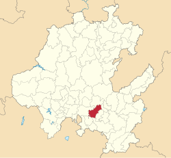
Hidalgo, officially the Free and Sovereign State of Hidalgo, is one of the 32 states which constitute the Federal Entities of Mexico. It is divided into 84 municipalities and its capital city is Pachuca de Soto.

Pachuca City and Municipality in Hidalgo, Mexico

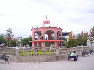
Pachuca, formally known as Pachuca de Soto, is the capital and largest city of the Mexican state of Hidalgo. It is located in the south-central part of the state. Pachuca de Soto is also the name of the municipality of which the city serves as municipal seat. Pachuca is located about 90 kilometres (56 mi) from Mexico City via Mexican Federal Highway 85. There is no consensus about the origin of the name Pachuca. It has been traced to the word pachoa, Pachoacan, and patlachuican.

Municipalities of Hidalgo Wikimedia list article

Hidalgo is a state in East Mexico that is divided into 84 municipalities. According to the 2015 Mexican Intercensal Survey, Hidalgo is the 17th most populous state with 2,858,359 inhabitants and the 26th largest by land area spanning 20,813 square kilometres (8,036 sq mi).

Ojinaga Municipality Municipality in Chihuahua, Mexico

Ojinaga Municipality is one of the 67 municipalities of Chihuahua, in northern Mexico. The municipal seat lies at Ojinaga, a rural bordertown on the U.S.-Mexico border. The municipality has an area of 9,500.50 km².

Mineral del Monte Municipality and town in Hidalgo, Mexico

Mineral del Monte, commonly called Real del Monte or El Real, is a small mining town, and one of the 84 municipalities of Hidalgo, in the State of Hidalgo in east-central Mexico.

Villaflores, Chiapas Municipality in Chiapas, Mexico

Villaflores Municipality is a municipio (municipality) in the state of Chiapas, southern Mexico, and the name of its largest settlement and seat of the municipal government. Situated in the Sierra Madre de Chiapas range, the municipality has an area of approximately 1232 km2 at an average elevation of 540m above mean sea level.

Hidalgo del Parral Municipality Municipality in Chihuahua, Mexico

Hidalgo del Parral is one of the 67 municipalities of Chihuahua, in northern Mexico. The municipal seat lies at Hidalgo del Parral. The municipality covers an area of 1,751 km².

Tepezalá Municipality in Aguascalientes, Mexico

Tepezalá is a municipality and town in the Mexican state of Aguascalientes. The town of Tepezalá serves as the municipal seat for the surrounding municipality of Tepezalá.

Acatlán, Hidalgo Town & Municipality in Hidalgo, Mexico

Acatlán is a town and municipality located in the Mexican state of Hidalgo, about ten km northwest of the city of Tulancingo and 147 km from Mexico City. The main landmark is the San Miguel monastery which was built in the 16th century. It is partially in ruins but there have been efforts since the 1980s to restore it. Acatlán comes from a Nahuatl phrase which means “near the reeds”.

Ajacuba Municipality in Hidalgo, Mexico

Ajacuba is a town and one of the 84 municipalities of Hidalgo, in central Mexico. The municipality covers an area of 192.7 km².

Atotonilco de Tula Municipality and city in Hidalgo, Mexico

Atotonilco de Tula is one of the 84 municipalities of Hidalgo. It is located in the central-southeastern part of the state of Hidalgo in Mexico. The municipal seat is Atotonilco de Tula. The municipality is located at a southern pass leading out of the Mezquital Valley to 86 kilometers north of Mexico City and about 180 km northeast of the state capital of Pachuca de Soto. The name comes from Nahuatl and means "place of hot springs" and otomi language is Padehe. The municipality covers an area of 31 km².

Mineral de la Reforma Municipality in Hidalgo, Mexico

Mineral de la Reforma is one of the 84 municipalities of Hidalgo, in central-eastern Mexico. Adjacent to Pachuca in the same built up area, it is one of the fastest growing cities of Hidalgo State. As of 2005, the municipality had a total population of 68,704.

San Agustín Tlaxiaca Municipality and town in Hidalgo, Mexico

San Agustín Tlaxiaca is a town and one of the 84 municipalities of Hidalgo, in central-eastern Mexico. The municipality covers an area of 354.6 km².

Apaxco Municipality and town in Mexico, Mexico

Apaxco is a municipality located in the Zumpango Region in Mexico. The municipal territory is located at a southern pass leading out of the Mezquital Valley about 288 km (179 mi) northeast of the state capital of Toluca. The name Apaxco comes from Nahuatl.

Tlaxco Municipality, Tlaxcala Municipality in Tlaxcala, Mexico

Tlaxco is a municipality in Tlaxcala, Mexico.

Río Grande Municipality, Zacatecas Municipality in Zacatecas, Mexico

Río Grande is a municipality in the Mexican state of Zacatecas.

Las Minas, Veracruz Municipality in Veracruz, Mexico

Las Minas is a municipality in the Mexican state of Veracruz, located 28 kilometres (17 mi) northeast of the state capital Xalapa.

Tepetzintla, Veracruz Municipality in Veracruz, Mexico

Tepetzintla is a municipality in the Mexican state of Veracruz, located 207 kilometres (129 mi) northwest of the state capital of Xalapa and 119 kilometres (74 mi) south of the city of Tampico.

Zacualpan, Veracruz Municipality in Veracruz, Mexico

Zacualpan is a municipality in the Mexican state of Veracruz, located 179 kilometres (111 mi) northwest of the state capital of Xalapa and 56 kilometres (35 mi) northeast of the city of Pachuca, Hidalgo.

The Pachuca Range is a mountain range in the Sierra Madre Oriental of central Mexico, in the state of Hidalgo.

References

  1. Pachuca municipality SEDESOL, Catálogo de localidades.
  2. INEGI (2009). "Link to tables of population data from Census of 2009 INEGI: Instituto Nacional de Estadística, Geografía e Informática" (PDF). Archived from the original (PDF) on 2016-09-23.
  3. 1 2 "Principales resultados por localidad 2005 (ITER)". INEGI. Archived from the original on 2011-07-22. Retrieved 2009-10-08.
  4. 1 2 3 4 "Estado de Hidalgo Pachuca de Soto" (in Spanish). Enciclopedia de los Municipios de México. Archived from the original on 2011-05-17. Retrieved 2009-10-08.
  5. "Fundación, historia y desarrollo de Pachuca" [The founding, history and development of Pachuca] (in Spanish). Mexico City: El Clima. Retrieved 2009-10-08.
  6. Pachuca municipality SEDESOL, Catálogo de localidades.

Coordinates: 20°07′N98°44′W / 20.117°N 98.733°W / 20.117; -98.733