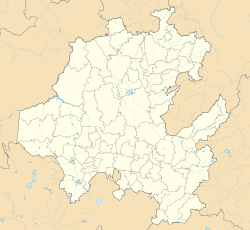
Santiago Tulantepec, Hidalgo | |
---|---|
Coordinates: 20°2′23″N98°21′27″W / 20.03972°N 98.35750°W Coordinates: 20°2′23″N98°21′27″W / 20.03972°N 98.35750°W | |
Country | |
State | |
Municipality | Tulantepec de Lugo Guerrero |
Elevation | 2,174 m (7,133 ft) |
Population (2010 Census) [1] | |
• Total | 16,078 |
Time zone | UTC−6 (CST) |
• Summer (DST) | UTC−5 (CDT) |
Santiago Tulantepec is a town in Mexico that is the municipal seat of Tulantepec de Lugo Guerrero, in the state of Hidalgo..
The Treaty of Guadalupe Hidalgo, officially titled the Treaty of Peace, Friendship, Limits and Settlement between the United States of America and the Mexican Republic, is the peace treaty that was signed on February 2, 1848, in the Villa de Guadalupe Hidalgo between the United States and Mexico that ended the Mexican–American War (1846–1848). The treaty was ratified by the United States on March 10 and by Mexico on May 19. The ratifications were exchanged on May 30, and the treaty was proclaimed on July 4, 1848.
Don Miguel Gregorio Antonio Francisco Ignacio Hidalgo-Costilla y Gallaga Mandarte Villaseñor, more commonly known as Don Miguel Hidalgo y Costilla or Miguel Hidalgo, was a Spanish Catholic priest, a leader of the Mexican War of Independence, and recognized as the Father of the Nation.
Hidalgo, officially the Free and Sovereign State of Hidalgo, is one of the 32 states which constitute the Federal Entities of Mexico. It is divided into 84 municipalities and its capital city is Pachuca de Soto.
Federal Highway 85 connects Mexico City with the Mexico–United States border at Nuevo Laredo, Tamaulipas. Highway 85 runs through Monterrey, Nuevo León; Ciudad Victoria, Tamaulipas; Ciudad Valles, San Luis Potosí; and Pachuca, Hidalgo. It ends at the intersection of Highway 95 in the San Pedro area of Mexico City. Highway 85 is the original route of the Pan-American Highway from the border to the capital as well as the Inter-American Highway.
The Tlaxcalans, or Tlaxcaltecs, are an indigenous group of Nahua ethnicity who inhabited the republic of Tlaxcala and present-day Mexican state of Tlaxcala.
Sabinas Hidalgo is a city and municipality located at the Mexican state of Nuevo León.
De Lugo may refer to: j m
Jiquipilco Municipality is one of the municipalities of the State of Mexico in Mexico. It is north of the Toluca Valley, part of the region consisting of the southern and western slopes of Cerro La Catedral, which has a concentration of speakers of the Otomi language. It is about 40 km from Toluca, the state capital. The name is a corruption of Nahuatl “Xiquipilli”, meaning “the place of saddlebags”. Jiquipilco is situated on the transversal volcanic axis that crosses Mexico in an area surrounded by lakes and volcanoes. This portion is called "Anahuac”.
Putla Villa de Guerrero or simply Putla, is a town and municipality in the State of Oaxaca, Mexico. It is part of Putla District in the west of the Sierra Sur Region.
Ajacuba is a town and one of the 84 municipalities of Hidalgo, in central Mexico. The municipality covers an area of 192.7 km².
Santiago de Anaya is a town and one of the 84 municipalities of Hidalgo, in central-eastern Mexico. The municipality covers an area of 316.1 km². The town is famous for its annual gastronomic festival, held for the last 37 years, featuring dishes prepared with plants and animals native to the region, including coyote, armadillo, rabbit, various snakes and xamues - long-legged plant-eating bugs. The festival, held during Easter week attracts thousands of tourists.
Tulantepec de Lugo Guerrero is one of the 84 municipalities of Hidalgo, in central-eastern Mexico. The municipality covers an area of 89.9 km².
San Martín de Hidalgo, formerly San Martín de la Cal, is the largest town and municipal seat of San Martín de Hidalgo Municipality, in Jalisco in central-western Mexico. As of 2015, the town had a population of 7,819. It is located 10 miles southeast of the city of Ameca and 8 miles northwest of the city of Cocula.
Chicontepec is a municipality in Veracruz, Mexico. It is located in the north of the State of Veracruz. It has a surface area of 978 square kilometres (378 sq mi). It is located at 20°58′N98°10′W.
Ilamatlán is a municipality in Veracruz, Mexico. It is located in central zone of the State of Veracruz, about 210 km from state capital Xalapa. It has a surface of 188.63 km2. It is located at 20°47′N98°27′W.
Tlaxiaco District is located in the south of the Mixteca Region of the State of Oaxaca, Mexico. The main city is the Heroic City of Tlaxiaco
Silacayoapam District is located in the northwest of the Mixteca Region of the State of Oaxaca, Mexico.
Víctor Ruiz del Valle was a Mexican football midfielder with Cruz Azul.
The following television stations broadcast on digital or analog channel 22 in Mexico:
This article about a location in the Mexican state of Hidalgo is a stub. You can help Wikipedia by expanding it. |