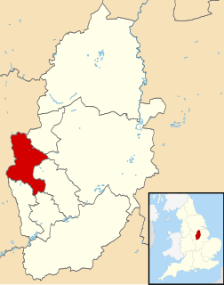
Ashfield is a local government district in western Nottinghamshire, England. The population of Ashfield was 127,200 in 2018. The district is mostly urban and contains parts of both the Nottingham Urban Area and the Mansfield Urban Area. There are three towns in the district; Sutton-in-Ashfield, Kirkby-in-Ashfield and Hucknall. The largest being Sutton-in-Ashfield. Towns and villages in the district include the following:

Broxtowe is a local government district with borough status in Nottinghamshire, England, west of the City of Nottingham. The population of the district as taken at the 2011 Census was 109,487. It is part of the Nottingham Urban Area. Broxtowe's neighbour to the west is the borough of Erewash, which is in Derbyshire.
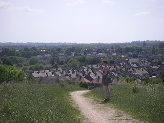
Hucknall, formerly Hucknall Torkard, is a market town in the Ashfield district of Nottinghamshire, England. It lies 7 miles north of Nottingham, 7 miles south-east of Kirkby-in-Ashfield, 9 miles from Mansfield and 10 miles south of Sutton-in-Ashfield. It is the second largest town in the Ashfield district after Sutton-in-Ashfield.

Bolsover is a local government district in Derbyshire, England. It is named after the town of Bolsover, which is near the geographic centre of the district, but the council is based in Clowne. At the 2011 Census, the district had a population of 75,866.

Ashfield is a constituency represented in the House of Commons of the UK Parliament by Lee Anderson of the Conservative Party. The constituency is in the English county of Nottinghamshire, East Midlands; located to the north west of the city of Nottingham in the Erewash Valley along the border with neighbouring county Derbyshire. Ashfield was part of the Red Wall which by and large, voted Conservative in the 2019 general election. In the 2016 referendum on membership of the European Union, Ashfield voted 70% in favour of Brexit.
Broxtowe is a parliamentary constituency in Nottinghamshire, England, represented in the House of Commons of the UK Parliament since 2019 by Darren Henry, a Conservative.

Broxtowe was a wapentake of the ancient county of Nottinghamshire, England.

Basford was a rural district close to Nottingham, England, from 1894 to 1974. The district consisted of two detached parts, to the north and south of Nottingham. It was created under the Local Government Act 1894 based on the existing Basford rural sanitary district.

Linby is a small village and civil parish in Nottinghamshire, England. The nearest town is Hucknall which is immediately to the south-west. The village grew up around the mills on the River Leen, from which Linby's name is derived. Small streams known as Linby Docks run on both sides of the main street. The population of the civil parish at the 2011 census was 232.

Papplewick is a village and civil parish in Nottinghamshire, England, 7.5 miles (12 km) north of Nottingham and 6 miles (10 km) south of Mansfield. It had a population of 756 at the 2011 census. In the Middle Ages, the village marked the southern gateway to Sherwood Forest.
Skegby was a rural district in Nottinghamshire, England from 1894 to 1935.

Blackwell was a rural district in Derbyshire, England from 1894 to 1974. It was created under the Local Government Act 1894 based on that part of the Mansfield rural sanitary district which was in Derbyshire.

The Leen Valley is the wide valley formed by the River Leen within the county of Nottinghamshire.
Carlton was a constituency in Nottinghamshire which returned one Member of Parliament (MP) to the House of Commons of the Parliament of the United Kingdom from 1950 until it was abolished for the 1983 general election. It was then partly replaced by the new Gedling constituency.
Arnold was an urban district in the English ceremonial county of Nottinghamshire from 1894 to 1974. It was created under the Local Government Act 1894.

Kirkby in Ashfield was an Urban District in Nottinghamshire, England from 1896 to 1974. It was created under the Local Government Act 1894.
Sutton in Ashfield was an Urban District in Nottinghamshire, England from 1894 to 1974. It was created under the Local Government Act 1894.
