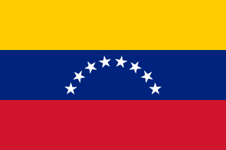
Venezuela, officially the Bolivarian Republic of Venezuela, is a country on the northern coast of South America, consisting of a continental landmass and many islands and islets in the Caribbean Sea. It has a territorial extension of 916,445 km2 (353,841 sq mi), and its population was estimated at 29 million in 2022. The capital and largest urban agglomeration is the city of Caracas.

Venezuela is a country in South America, bordering the Caribbean Sea and the North Atlantic Ocean, between Colombia and Guyana. It is situated on major sea and air routes linking North and South America. Located at the northernmost end of South America, Venezuela has a total area of 912,050 km2 (352,140 sq mi) and a land area of 882,050 km2 (340,560 sq mi). It is the 32nd largest country and is slightly smaller than Egypt, or half the size of Mexico. Shaped roughly like an inverted triangle, the country has a 2,800 km (1,700 mi) long coastline. It is bound on the north by the Caribbean Sea and the Atlantic Ocean, on the east by Guyana, on the south by Brazil, and on the west by Colombia. It has the 55th largest Exclusive Economic Zone of 471,507 km2 (182,050 sq mi). Its maritime territory borders Trinidad and Tobago, Dominica, the Dominican Republic, Grenada, St. Kitts and Nevis, St. Vincent and the Grenadines, France, the United Kingdom, the Netherlands, and the United States. Venezuela also claims the region of Guayana Esequiba, currently under the control of Guyana.

Caracas, officially Santiago de León de Caracas, abbreviated as CCS, is the capital and largest city of Venezuela, and the center of the Metropolitan Region of Caracas. Caracas is located along the Guaire River in the northern part of the country, within the Caracas Valley of the Venezuelan coastal mountain range. The valley is close to the Caribbean Sea, separated from the coast by a steep 2,200-meter-high (7,200 ft) mountain range, Cerro El Ávila; to the south there are more hills and mountains. The Metropolitan Region of Caracas has an estimated population of almost 5 million inhabitants.

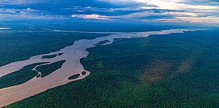
The Orinoco is one of the longest rivers in South America at 2,250 kilometres (1,400 mi). Its drainage basin, sometimes known as the Orinoquia, covers 989,000 km2 (382,000 sq mi), with 76.3 percent of it in Venezuela and the remainder in Colombia. It is the fourth largest river in the world by discharge volume of water. The Orinoco River and its tributaries are the major transportation system for eastern and interior Venezuela and the Llanos of Colombia. The environment and wildlife in the Orinoco's basin are extremely diverse.

The Guiana Shield is one of the three cratons of the South American Plate. It is a 1.7 billion-year-old Precambrian geological formation in northeast South America that forms a portion of the northern coast. The higher elevations on the shield are called the Guiana Highlands, which is where the table-like mountains called tepuis are found. The Guiana Highlands are also the source of some of the world's most well-known waterfalls such as Angel Falls, Kaieteur Falls and Cuquenan Falls.
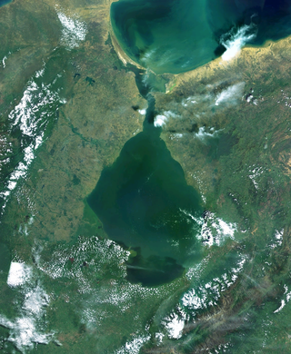
Lake Maracaibo is a lagoon in northwestern Venezuela, the largest lake in South America and one of the oldest on Earth, formed 36 million years ago in the Andes Mountains. The fault in the northern section has collapsed and is rich in oil and gas resources. It is Venezuela's main oil producing area and an important fishing and agricultural producing area. Eutrophication caused by oil pollution is a major environmental problem facing the lake. The area around the lake is inhabited by a quarter of the country's population and is also the place with the most frequent lightning on earth. The famous Catatumbo lightning can illuminate nighttime navigation.

Trinidad is the larger and more populous of the two major islands of Trinidad and Tobago. The island lies 11 km (6.8 mi) off the northeastern coast of Venezuela and sits on the continental shelf of South America. It is often referred to as the southernmost island in the West Indies. With an area of 4,768 km2 (1,841 sq mi), it is also the fifth largest in the West Indies.
The Essequibo River is the largest river in Guyana, and the largest river between the Orinoco and Amazon. Rising in the Acarai Mountains near the Brazil–Guyana border, the Essequibo flows to the north for 1,014 kilometres (630 mi) through forest and savanna into the Atlantic Ocean. With a total drainage basin of 156,828 square kilometres (60,552 sq mi) and an average discharge of 4,531–5,650 cubic metres per second (160,000–199,500 cu ft/s).

Amazonas State is one of the 23 states into which Venezuela is divided. It covers nearly a fifth of the area of Venezuela, but has less than 1% of Venezuela's population.
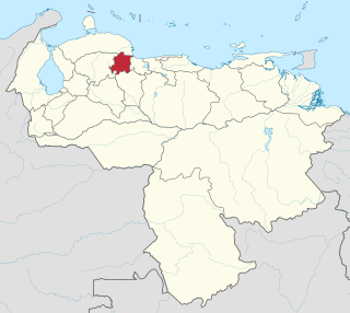
Yaracuy is one of the 23 states of Venezuela. Yaracuy is located in the Central-Western Region, Venezuela. It is bordered by Falcón in the north, in the west by Lara, in the south by Portuguesa and Cojedes and in the east by Cojedes and Carabobo.

The classification of the Indigenous peoples of the Americas is based upon cultural regions, geography, and linguistics. Anthropologists have named various cultural regions, with fluid boundaries, that are generally agreed upon with some variation. These cultural regions are broadly based upon the locations of the Indigenous peoples of the Americas from early European and African contact beginning in the late 15th century. When Indigenous peoples have been forcibly removed by nation-states, they retain their original geographic classification. Some groups span multiple cultural regions.

The Panyols are a pardo or moreno (tri-racial) ethnic group in Trinidad and Tobago of Afro-Spanish-Indigenous descent, primarily of mixed South American Amerindian, Trinidad and Tobago Amerindian, Afro-Trinidadian, Afro-Venezuelans and Spanish descent. The name is a derivation of the word 'español', as well as the community's settlement in what became predominantly cocoa cultivated regions of Trinidad. Also referred to as Pagnols or Payols, the panyol communities draw cultural influence from both sides of the Gulf of Paria, and are predominantly found within the Northern Range rainforest mountains and valleys of Trinidad, with South American cultural influences most predominantly derived from regions around the Orinoco, and Caura River, Venezuela.

The Guianas, sometimes called by the Spanish loan-word Guayanas, is a region in north-eastern South America which includes the following three territories:

The Guajira Peninsula[ɡwaˈxiɾa] is a peninsula in northern Colombia and northwestern Venezuela in the Caribbean. It is the northernmost peninsula in South America and has an area of 25,000 km2 (9,700 sq mi) extending from the Manaure Bay (Colombia) to the Calabozo Ensenada in the Gulf of Venezuela (Venezuela), and from the Caribbean to the Serranía del Perijá mountains range.

The Catatumbo River is a river rising in northern Colombia, flowing into Lake Maracaibo in Venezuela. The Catatumbo River is approximately 340 kilometres (210 mi) long. It forms a part of the international boundary between the two countries. The river's name means "House of Thunder" in the language of the Bari people.

The Cordillera Oriental is the widest of the three branches of the Colombian Andes. The range extends from south to north dividing from the Colombian Massif in Huila Department to Norte de Santander Department where it splits into the Serranía del Perijá and the Cordillera de Mérida in Venezuelan Andes. The highest peak is Ritacuba Blanco at 5,410 m (17,750 ft) in the Sierra Nevada del Cocuy.
Arutani is a nearly extinct language spoken in Roraima, Brazil and in the Karum River area of Bolivar State, Venezuela. There are only around 6 speakers left.

The slate-colored hawk is a species of bird of prey in the family Accipitridae: the hawks, eagles, and allies.

The violaceous jay is a species of bird in the family Corvidae, the crows and their allies.
