
Cumberland is the northeasternmost town in Providence County, Rhode Island, United States, first settled in 1635 and incorporated in 1746. The population was 36,405 at the 2020 census, making it the seventh-largest municipality and the largest town in the state.

Johnston is a town in Providence County, Rhode Island, United States. The population was 29,568 at the 2020 census. Johnston is the site of the Clemence Irons House (1691), a stone-ender museum, and the only landfill in Rhode Island. Incorporated on March 6, 1759, Johnston was named for the colonial attorney general, Augustus Johnston.

North Smithfield is a town in Providence County, Rhode Island, United States, settled as a farming community in 1666 and incorporated into its present form in 1871. North Smithfield includes the historic villages of Forestdale, Primrose, Waterford, Branch Village, Union Village, Park Square, Cassidyland, Boutelleville and Slatersville. The population was 12,588 at the 2020 census.

Hope Valley is a village and census-designated place (CDP) in the town of Hopkinton in Washington County, Rhode Island, United States. The population of the CDP was 1,612 at the 2010 census. Hope Valley is the largest village in Hopkinton and the town's principal commercial center. While the village of Hope Valley is located in Hopkinton, its zip code, 02832, extends into the neighboring town of Richmond.

West Warwick is a town in Kent County, Rhode Island, United States. The population was 31,012 at the 2020 census.

North Providence is a town in Providence County, Rhode Island, United States. The population was 34,114 at the 2020 census.

Riverside is a neighborhood in the city of East Providence in the U.S. state of Rhode Island. Despite not being an incorporated city, Riverside has its own zip code, 02915, and is an acceptable mailing address according to the United States Postal Service. Riverside has a population of approximately 20,000 people.

Peace Dale is a village in the town of South Kingstown, Rhode Island. Together with the village of Wakefield, it is treated by the U.S. Census as a component of the census-designated place identified as Wakefield-Peacedale, Rhode Island.

Thornton is a neighborhood located in the north-west part of Cranston, Rhode Island on the Johnston line and extends into the Johnston side.

Hillsgrove, originally Hill's Grove, is a village in western central Warwick, Rhode Island.

Apponaug is a neighborhood in central Warwick, Rhode Island, United States, situated on Apponaug Cove, a tributary to Greenwich Bay and nearby Narragansett Bay. The name Apponaug is a derivation of the Narragansett Indian word for "place of oysters". Indeed, Apponaug Cove holds one of the richest shellfish beds in the United States and was densely populated by the Narragansett people for many centuries prior to the arrival of European settlers.

Smith Hill is a neighborhood in Providence, Rhode Island. Its traditional bounds are the Woonasquatucket River, the Chad Brown public housing complex, Interstate 95 and West River.
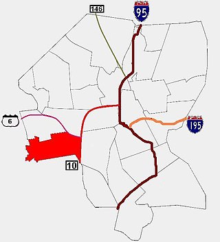
Silver Lake is a neighborhood on the western edge of Providence, Rhode Island. It is bordered by the Hartford neighborhood to the north, Route 10 to the east, Johnston and Cranston on the West and separated from Olneyville by Route 6.
Forestdale is a village and historic district in North Smithfield, Providence County, Rhode Island, United States, one-half mile from Slatersville, Rhode Island. The historic district runs east and west along Main Street and north on Maple Avenue. School Street is the primary road through the village, and the one-room schoolhouse for which the street is named still stands. The Branch River runs through the valley adjacent to the School Street. The Village Haven Restaurant and local VFW chapter are also located in the village.

Manton is a residential neighborhood in Providence, Rhode Island and part of Johnston, Rhode Island. It is in the westernmost part of the city. of Providence The town of North Providence borders it to the north, Johnston to the west, while the neighborhoods of Hartford, Olneyville, and Mount Pleasant border it inside Providence. Separating it from other Providence neighborhoods to its east are Rushmore Ave, Chalkstone Ave, Smith Street, and the Triggs Memorial Golf Course. The Woonasquatucket River separates it from Johnston to the west.
Oakland is a village in Burrillville, Providence County, Rhode Island, United States. It was developed in the 19th century at the site of a stone mill near the confluence of the Chepachet and Clear Rivers. It is one of the few remaining stone mills in this state. Most of the village is included in the Oakland Historic District, a historic district listed on the National Register of Historic Places. Most of the housing in the village was originally built to house mill workers, although there are several more elaborate houses built for mill executives.

The Pachaug River is a 16.0-mile-long (25.7 km) river arising from the Pachaug State Forest at the Connecticut - Rhode Island border and draining into the Quinebaug River. It is crossed by the Ashland Mill Bridge in Griswold, Connecticut, a bridge which is listed on the U.S. National Register of Historic Places.
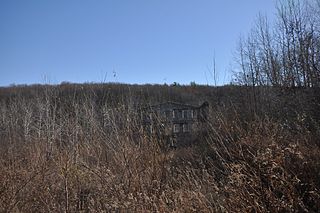
The Stillwater Mill was a former textile factory located in Smithfield, Rhode Island.
Graniteville is a village located within the town of Johnston, Rhode Island.
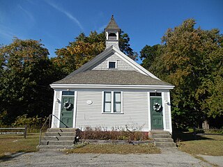
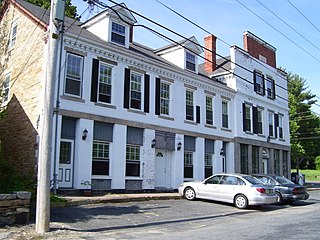
Belknap School is a historic former school house at 509 Greenville Avenue in the Belknap village of Johnston, Rhode Island.
