Hulsey Yard

Last updated

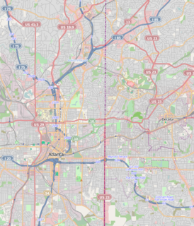
Hulsey Yard is a rail yard of the CSX railroad, stretching approximately 0.9 miles (1.4 km) along the border of the Old Fourth Ward, Inman Park, Cabbagetown and Reynoldstown neighborhoods of Atlanta. The south wall of the rail yard along Wylie Street in Reynoldstown is one of the most prominent locations for street art in Atlanta. The art is managed by the Wallkeepers Committee of the Cabbagetown Neighborhood Improvement Association, [1]

Rail yard location for storing and sorting railroad cars

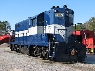
A rail yard, railway yard or railroad yard is a complex series of railroad tracks for storing, sorting, or loading and unloading, railroad cars and locomotives. Railroad yards have many tracks in parallel for keeping rolling stock stored off the mainline, so that they do not obstruct the flow of traffic. Railroad cars are moved around by specially designed yard switchers, a type of locomotive. Cars in a railroad yard may be sorted by numerous categories, including railroad company, loaded or unloaded, destination, car type, or whether they need repairs. Railroad yards are normally built where there is a need to store cars while they are not being loaded or unloaded, or are waiting to be assembled into trains. Large yards may have a tower to control operations.

CSX Transportation railway system in the United States of America

CSX Transportation is a Class I railroad operating in the eastern United States and the Canadian provinces of Ontario and Quebec. The railroad operates approximately 21,000 route miles (34,000 km) of track. The company operates as a subsidiary of CSX Corporation, a Fortune 500 company headquartered in Jacksonville, Florida.

Old Fourth Ward Neighborhoods of Atlanta in Fulton County, Georgia, United States

The Old Fourth Ward, often abbreviated O4W, is an intown neighborhood on the eastside of Atlanta, Georgia, United States. The neighborhood is best known as the location of the Martin Luther King, Jr. historic site.

Hulsey Yard was originally part of the Georgia Railroad and Banking Company.

Georgia Railroad and Banking Company

The Georgia Railroad and Banking Company also seen as "GARR", was a historic railroad and banking company that operated in the U.S. state of Georgia. In 1967 it reported 833 million revenue-ton-miles of freight and 3 million passenger-miles; at the end of the year it operated 331 miles (533 km) of road and 510 miles (820 km) of track.

MARTA's Blue Line and Green Line traverses the rail yard.

Metropolitan Atlanta Rapid Transit Authority public transit operator in Metro Atlanta, Georgia

The Metropolitan Atlanta Rapid Transit Authority is the principal public transport operator in the Atlanta metropolitan area. Formed in 1971 as strictly a bus system, MARTA operates a network of bus routes linked to a rapid transit system consisting of 48 miles (77 km) of rail track with 38 train stations. It is the eighth-largest rapid transit system in the United States by ridership.

The Blue Line is a rapid transit line in the MARTA rail system. It operates between Hamilton E. Holmes and Indian Creek stations, running through Atlanta, Decatur and portions of unincorporated DeKalb County.

The yard is a key node on the BeltLine trail, whose northeast section terminates across Decatur Street/DeKalb Avenue from the west end of the yard, and whose southeast section terminates at the east end of the yard, and poses as issue as to how to connect the two sections of the trail across the yard. [2] [3]

The BeltLine is a former railway corridor around the core of Atlanta, Georgia, under development in stages as a multi-use trail. Some portions are already complete, while others are still in a rough state but hikeable. Using existing rail track easements, the BeltLine is designed to improve transportation, add green space, and promote redevelopment. There are longer-term visions for streetcar or light-rail lines along all or part of the corridor.

Decatur Street (Atlanta)

Decatur Street is one of the original 7 streets of Atlanta, Georgia; it was also a famous entertainment area from the 1850s through the early 20th century.

The BeltLine and other local organizations also use the designation Hulsey Yard name to designate a natural habitat on the subcontinental divide, and an associated "arboretum" or nature walk that it promotes in the area. [4]

Related Research Articles

Inman Park human settlement in Atlanta, Georgia, United States of America

Inman Park is an intown neighborhood on the east side of Atlanta, Georgia, and its first planned suburb. It was named for Samuel M. Inman.

Poncey–Highland Neighborhoods of Atlanta in Fulton County, Georgia, United States

Poncey–Highland is an intown neighborhood on the east side of Atlanta, Georgia, located south of Virginia–Highland. It is so named because it is near the intersection of east/west Ponce de Leon Avenue and north/southwest North Highland Avenue. This Atlanta neighborhood was established between 1905 and 1930, and is bordered by Druid Hills and Candler Park across Moreland Avenue to the east, the Old Fourth Ward across the BeltLine Eastside Trail to the west, Inman Park across the eastern branch of Freedom Parkway to the south, and Virginia Highland to the north across Ponce de Leon Avenue. The Little Five Points area sits on the border of Poncey–Highland, Inman Park, and Candler Park.

Cabbagetown, Atlanta human settlement in Atlanta, Georgia, United States of America

Cabbagetown is an intown neighborhood on the east side of Atlanta, Georgia, United States, abutting historic Oakland Cemetery. It includes the Cabbagetown District, a historic district listed on the U.S. National Register of Historic Places.

Reynoldstown, Atlanta human settlement in Atlanta, Georgia, United States of America

Reynoldstown is a historic district and intown neighborhood on the near east side of Atlanta, Georgia located only 2 miles from downtown. The neighborhood is gentrifying and attracting new families, empty-nesters, Atlantans opposed to long commutes; as well as diverse culture of first-time homebuyers, single professionals, artist and students due to its close proximity to other nearby intown neighborhoods, high walkability index, urban amenities and nearby bohemian hotspots on Carroll Street in the adjoined-at-the-hip also historic Cabbagetown neighborhood and in other surrounding communities.

Edgewood is a neighborhood located on the east side of Atlanta, Georgia, United States, located approximately three miles (5km) east of downtown Atlanta.

Westview, Atlanta CDP in Georgia, United States

Westview is a historic intown neighborhood located in southwest Atlanta, Georgia. It is named for the Westview Cemetery that borders the neighborhood to the northwest. The neighborhood is made up of a mixture of architectural styles including Arts & Crafts bungalows, Four-Squares, Tudors, Minimal Traditional houses, and Ranch style houses.

Capitol View, Atlanta human settlement in Atlanta, Georgia, United States of America

Capitol View is an in-town Atlanta neighborhood 2.5 miles from downtown Atlanta, Georgia that was named for its excellent view of the Georgia State Capitol building. Its boundaries include Metropolitan Parkway to the east, Lee Street to the west, and the Beltline to the north. On the south, the border follows Arden Street, Deckner Avenue, and Perkerson Park. Its central location is only minutes away from Atlanta Downtown Atlanta, Midtown Atlanta, Buckhead, College Park, East Point, Hartsfield-Jackson Atlanta International Airport, and major highways and interstates such as the Downtown Connector/I-75/I-85, I-20, and Metropolitan Parkway.

Adair Park human settlement in Atlanta, Georgia, United States of America

Adair Park is a residential neighborhood located southwest of downtown Atlanta. It has the form of a left curly bracket, bordered by the MARTA north-south rail line on the northwest, the BeltLine trail on the southwest and Metropolitan Parkway on the east. Historically Adair Park also included the area from Metropolitan Parkway to McDaniel Street on the east, but the city now considers that area part of the Pittsburgh neighborhood.

Pittsburgh, Atlanta Neighborhoods of Atlanta in Fulton County, Georgia, United States

Pittsburgh is a neighborhood of Atlanta, Georgia, founded in 1883 as a black working-class suburb alongside the Pegram rail shops. It was named Pittsburgh because the industrial area reminded one of Pittsburgh, Pennsylvania and its famous steel mills. Pittsburgh is relatively poor and underdeveloped, but as property values rise in Intown Atlanta neighborhoods, many see hope that this trend will spread to Pittsburgh and bring renewal.

Streetcars in Atlanta

Streetcars originally operated in Atlanta downtown and into the surrounding areas from 1871 until the final line's closure in 1949.

Glenwood Park

Glenwood Park is a mixed-use neighborhood on the east side of Atlanta, Georgia, United States, located just west of North Ormewood Park. The neighborhood is an example of New Urbanism, promoting a sense of community with walkable streets and closely spaced residential units that are mixed in with office, retail, and green space. Glenwood Park is on the BeltLine, a former rail line converted to a trail, with transit to be constructed in the future.

Brookwood is a neighborhood at the southernmost tip of the Buckhead Community of Atlanta. It should not be confused with Brookwood Hills, a neighborhood and historic district east of Brookwood across Peachtree Road.

Arts in Atlanta

The arts in Atlanta are well-represented, with a particularly prominent presence in music, fine art, and theater.

Krog Street Tunnel

The Krog Street Tunnel is a tunnel in Atlanta known for its street art. The tunnel links the Cabbagetown, Reynoldstown, and Inman Park neighborhoods. It is very popular among cyclists, and is proposed to be used as part of the BeltLine, for bicyclists and pedestrians to cross Hulsey Yard.

Street art in Atlanta

In recent years, Atlanta has become one of the USA's best cities for street art. Street artists have prominently created murals in Krog Street Tunnel, along the BeltLine, and in neighborhoods across the city. The street art conference, Living Walls, the City Speaks, originated in Atlanta in 2009.

Eastside, Atlanta city district comprising the easternmost portion of Atlanta, Georgia, United States

Eastside refers to the city district comprising the easternmost portion of Atlanta, Georgia, United States. The Eastside generally encompasses the area bounded on the west by Midtown Atlanta and Downtown Atlanta and on the east by the city limits. The central corridor of the district is the BeltLine Eastside Trail, which connects northern Eastside neighborhoods with those to the south. The Eastside is known for its nightlife establishments, craftsman architecture, local eateries, and quirky public art.

Timeline of the BeltLine

This is the timeline of the development of the BeltLine, a ring of trails and parks around central Atlanta.

References

  1. "CI Notes" (PDF). Cabbagetown Neighbors. p. 5.
  2. "The Blueprint for the Atlanta BeltLine". Atlanta BeltLine.
  3. "A vision in green: Proposal foretells 22-mile beltway of parks, trails". Atlanta Journal-Constitution. December 19, 2004.
  4. "Atlanta BeltLine Arboretum - Hulsey Yard". Atlanta BeltLine.

Coordinates: 33°45′10″N84°21′44″W / 33.7529°N 84.3623°W / 33.7529; -84.3623

Geographic coordinate system Coordinate system

A geographic coordinate system is a coordinate system that enables every location on Earth to be specified by a set of numbers, letters or symbols. The coordinates are often chosen such that one of the numbers represents a vertical position and two or three of the numbers represent a horizontal position; alternatively, a geographic position may be expressed in a combined three-dimensional Cartesian vector. A common choice of coordinates is latitude, longitude and elevation. To specify a location on a plane requires a map projection.