
The Metropolitan Atlanta Rapid Transit Authority is the principal public transport operator in the Atlanta metropolitan area. Formed in 1971 as strictly a bus system, MARTA operates a network of bus routes linked to a rapid transit system consisting of 48 miles (77 km) of rail track with 38 Subway stations. MARTA's rapid transit system is the eighth-largest rapid transit system in the United States by ridership.
The Atlanta BeltLine is a 22 miles (35 km) open and planned loop of multi-use trail and light rail transit system on a former railway corridor around the core of Atlanta, Georgia. The Atlanta BeltLine is designed to reconnect neighborhoods and communities historically divided and marginalized by infrastructure, improve transportation, add green space, promote redevelopment, create and preserve affordable housing, and showcase arts and culture. The project is in varying stages of development, with several mainline and spur trails complete and others in an unpaved, but hikeable, state. Since the passage of the More MARTA sales tax in 2016, construction of the light rail streetcar system is overseen by MARTA in close partnership with Atlanta BeltLine, Inc.

Doraville Assembly was a General Motors automobile factory in Doraville, Georgia, just northeast of Atlanta. The plant opened in 1947 and was under the management of GM's newly created Buick-Oldsmobile-Pontiac Assembly Division created in 1945. It was closed on 26 September 2008 as part of the company's cost-cutting measures. According to an article that appeared in the Atlanta Journal-Constitution on January 28, 2010, New Broad Street Doraville, LLC, a development company, has executed a purchase contract with General Motors to purchase the former plant, with plans to build a mixed-use, transit-oriented development. New Broad Street's deal fell through when DeKalb County decided against using its federal stimulus and property taxes dollars to partially fund the project.

Arts Center station is a train station in Atlanta, Georgia, serving the Red and Gold lines of the Metropolitan Atlanta Rapid Transit Authority (MARTA) rail system. It is the northernmost of three MARTA stations that serve Midtown Atlanta, the others being Midtown and North Avenue.

Lindbergh Center station is an at-grade train station in Atlanta, Georgia, serving the Red and Gold lines of the Metropolitan Atlanta Rapid Transit Authority (MARTA) rail system. It serves the Lindbergh/Morosgo neighborhood in southern Buckhead, and is a part-time terminus of the Red Line and the last transfer point for the Red and Gold (Doraville) rail lines. It is the only station on this route served by the Red and Gold lines at all times. This is the third busiest station in the MARTA system, handling an average of 23,400 boardings per weekday. It is important to the MARTA system for a number of reasons. It is adjacent to the MARTA headquarters building, located just north of the Armour Yard Rail Services Facility, which allows trains to come into service at a more central location than was previously possible, and at an important junction point for the future Belt Line and Clifton Corridor.

Five Points is a metro station of the Metropolitan Atlanta Rapid Transit Authority (MARTA) rail system in Atlanta, Georgia. It is the transfer point for all rail lines and serves as the main transportation hub for MARTA. It provides access to the Five Points Business District, Underground Atlanta, City Hall, the Richard B. Russell Federal Building, CobbLinc, Ride Gwinnett, GRTA Xpress Transit, and the tourism heart of Downtown Atlanta. It provides connecting bus service to Zoo Atlanta, Grant Park, Atlanta University Center, East Atlanta Village, Martin Luther King Jr. National Historical Park, Carter Center, Atlanta City Hall, South Dekalb Mall and Fulton County Government Center.

Doraville is a train station in Doraville, Georgia, and the northern terminus on the Gold Line of the Metropolitan Atlanta Rapid Transit Authority (MARTA) rail system. Doraville serves as the ground for the Doraville rail yard for the Gold line, with a capacity of 30 rail cars.

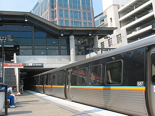
College Park is a train station in College Park, Georgia, United States, serving the Red and Gold lines of the Metropolitan Atlanta Rapid Transit Authority (MARTA) rail system. It opened on June 18, 1988. This station mainly serves College Park and surrounding areas, including Morrow, Riverdale, Clayton County, and South Fulton.
The MARTA rail network, a component of the MARTA transit system in Metro Atlanta, has four service lines: the Red, Gold, Blue, and Green Lines. The Red and Gold Lines mainly run along the North-Northeast corridor, and the Blue and Green Lines run along the West-East corridor. The two corridors connect at the Five Points station, which is the only station where transfers are possible between all four lines. In 2022, the system had a ridership of 28,198,300, or about 96,000 per weekday as of the second quarter of 2023.
The Metropolitan Atlanta Rapid Transit Authority was created as the first public mass transit agency in metropolitan Atlanta. Its formation in 1965 was a result of the campaigning efforts of governmental planning agencies and Atlanta businessmen. The system broke ground on its rail system in 1975.

Capitol View is a historic in-town southwest Atlanta neighborhood 2.5 miles from downtown Atlanta, Georgia that was named for its view of the Georgia State Capitol building. Its boundaries include Metropolitan Parkway to the east, Lee Street to the west, and the Beltline to the north. On the south, the border follows Arden Street, Deckner Avenue, and Perkerson Park.
The Georgia Rail Passenger Program (GRPP) was a set of plans, as yet unbuilt, for intercity and commuter rail in the U.S. state of Georgia.
The transportation system of Georgia is a cooperation of complex systems of infrastructure comprising over 1,200 miles (1,900 km) of interstates and more than 120 airports and airbases serving a regional population of 59,425 people.

Streetcars originally operated in Atlanta downtown and into the surrounding areas from 1871 until the final line's closure in 1949.
Lindbergh, officially Lindbergh/Morosgo, is a neighborhood in the Buckhead district of Atlanta, Georgia. Most of the neighborhood consists of multi-use development combining retail, office and residential space.

The Clifton Corridor is a proposed public transportation corridor in and near Atlanta, Georgia, roughly connecting the Buckhead, Emory University, and Decatur areas.
Peachtree Hills is a neighborhood within the Buckhead district of Atlanta, Georgia. It primarily contains residential buildings, however, commercial buildings are scattered throughout the neighborhood. Peachtree Battle Shopping Center is located within the borders of Peachtree Hills.
Atlanta's transportation system is a complex infrastructure of several systems, including 47.6 miles of heavy rail, 91 bus transit routes, 1,600 licensed taxis, a comprehensive network of freeways, the world's busiest airport and over 45 miles of bike paths.
Hulsey Yard is a rail yard of the CSX railroad, stretching approximately 0.9 miles (1.4 km) along the border of the Old Fourth Ward, Inman Park, Cabbagetown and Reynoldstown neighborhoods of Atlanta. The south wall of the rail yard along Wylie Street in Reynoldstown is one of the most prominent locations for street art in Atlanta. The art is managed by the Wallkeepers Committee of the Cabbagetown Neighborhood Improvement Association,
Clayton County commuter rail was a proposed commuter rail line traversing Clayton County, Georgia and connecting with the MARTA rapid transit system at East Point station. It was replaced by a BRT system by the Clayton County Board of Commissioners, the City Councils of Jonesboro, Forest Park, Lovejoy, Riverdale and Lake City, and the Clayton County Chamber of Commerce, MARTA Board of Directors Planning and Capital Programs Committee on Nov. 17, 2022 due to a variety of obstacles with right-of-way acquisition, environmental and historical resource concerns, along with a ballooning cost estimate.
