
1. Fußball-Club Kaiserslautern e. V., also known as 1. FCK, FCK, FC Kaiserslautern, K'lautern or colloquially Lautern, is a German sports club based in Kaiserslautern, Rhineland-Palatinate. In addition to football, the club also operates in several other sports.
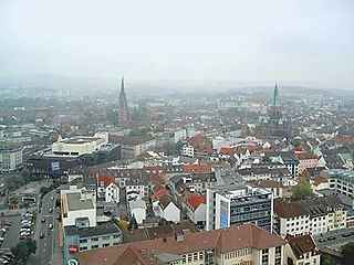
Kaiserslautern is a town in southwest Germany, located in the state of Rhineland-Palatinate at the edge of the Palatinate Forest. The historic centre dates to the 9th century. It is 459 kilometres from Paris, 117 km from Frankfurt am Main, 666 kilometers from Berlin, and 159 km from Luxembourg.
The Kaiserslautern Military Community (KMC) is an American military community in and around Kaiserslautern, Germany, supporting United States Armed Forces and NATO installations, such as the Ramstein Air Base, Landstuhl Regional Medical Center, Kapaun Air Station, Vogelweh Housing Area, Pulaski Barracks, Kleber Kaserne, Daenner Kaserne, Sembach Kaserne, Miesau Army Depot, and Rhine Ordnance Barracks. With around 54,000 people, including military service members, Department of Defense civilians and contractors as well as their families, the KMC is the largest U.S. military community outside of the United States.

Landstuhl, officially the Sickingen Town of Landstuhl, is a town in the district of Kaiserslautern, in Rhineland-Palatinate, Germany. It is the seat of the Municipal Association of Landstuhl. Situated on the north-west edge of the Palatinate Forest, 11 miles (18 km) west of the city of Kaiserslautern, the town is located near Ramstein Air Base.
Enkenbach-Alsenborn is a municipality in the district of Kaiserslautern, in Rhineland-Palatinate, Germany. It is situated on the northern edge of the Palatinate forest, approx. 10 km north-east of Kaiserslautern. Enkenbach-Alsenborn is also the seat of the Verbandsgemeinde, also named Enkenbach-Alsenborn.
Otterbach is a municipality in the district of Kaiserslautern, in Rhineland-Palatinate, Germany.

Bundesautobahn 63 is an autobahn in southwestern Germany. It connects the Mainz area to Kaiserslautern and the A 6 and is therefore an important connection between the Rhine/Main and the Saar areas. It was constructed during the 1980/90s and finished in 2004: last section Sembach to Kaiserslautern.
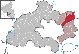
Sembach is a municipality in the district of Kaiserslautern in the state of Rhineland-Palatinate, Germany. It forms part of the Verbandsgemeinde of Enkenbach-Alsenborn. The town is nestled in the Palatinate Forest Nature Park between Kaiserslautern and Donnersbergkreis. Sembach was first mentioned in the 13th century, in a document about a donation to the monastery of Enkenbach.

Gundersweiler is a village and a municipality in the Verbandsgemeinde Nordpfälzer Land and the Donnersbergkreis district, in Rhineland-Palatinate, Germany. It is located in the valley of Moschelbach in the North Palatine Uplands, southwest of Donnersberg and between Kaiserslautern and Bad Kreuznach.

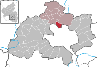
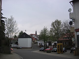
Mehlingen is a municipality in the district of Kaiserslautern, in Rhineland-Palatinate, western Germany.

Queidersbach is a municipality in the district of Kaiserslautern, in Rhineland-Palatinate, western Germany.

Rodenbach is a municipality in the district of Kaiserslautern, in Rhineland-Palatinate, Germany. It belongs to the Verbandsgemeinde Weilerbach.

The Humberg Tower is an observation tower on the Humberg hill, 425 metres high, to the south of the city of Kaiserslautern in southwest Germany.
1. FC Kaiserslautern II is the reserve team of German association football club 1. FC Kaiserslautern, based in Kaiserslautern, Rhineland-Palatinate. The team competes in the Oberliga Rheinland-Pfalz/Saar, the fifth tier of German football. Prior 2005, the team was named 1. FC Kaiserslautern Amateure.
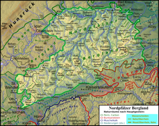
The North Palatine Uplands, sometimes shortened to Palatine Uplands, is a low mountain range and landscape unit in the German state of Rhineland-Palatinate and belongs mainly to the Palatinate region. It is part of the Saar-Nahe Uplands.

The Palatinate Forest Nature Park lies in the south of Rhineland-Palatinate in Germany and borders on France. The nature park covers an area of 177,100 hectares (684 sq mi) and some 76% of its area is under the woods of the Palatinate Forest, the largest contiguous forest region in Germany. Together with parts of northern Alsace and Lorraine, it forms the Palatinate Forest-North Vosges Biosphere Reserve and has an impressive Bunter sandstone landscape.

The Kaiserslautern University of Applied Sciences is a Hochschule with 3 campuses located in Kaiserslautern, Germany, in Pirmasens, Germany and in Zweibrücken, Germany. With about 6300 students, it is one of the largest Universities of Applied Sciences in the state of Rhineland-Palatinate.

The Alsenz Valley Railway is a line that runs from Hochspeyer via Winnweiler and Alsenz to Bad Munster am Stein in the German state of Rhineland-Palatinate. The line closely follows the Alsenz river from the Enkenbach district and crosses it several times. It was originally built primarily as a long-distance route, but it has lost this function since 1990 and is now exclusively used for local transport.

The Palatine Watershed forms the main drainage divide in the Palatinate between the Upper Rhine and the Middle Rhine, the two successive sections of the river Rhine that flow through the German state of Rhineland-Palatinate.

