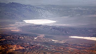
Groom Lake is a dry lake, also described as a salt flat, in Nevada. It is used for runways of the Nellis Bombing Range Test Site airport (KXTA). Part of the Area 51 USAF installation, it lies at an elevation of 4,409 ft (1,344 m) and is approximately 3.7 miles (6.0 km) from north to south and 3 miles (4.8 km) from east to west at its widest point, and is approximately 11.3 miles in circumference. Located within the namesake Groom Lake Valley portion of the Tonopah Basin, the lake is 25 mi (40 km) south of Rachel, Nevada.

Churchill County is a county in the western U.S. state of Nevada. As of the 2010 census, the population was 24,877. Its county seat is Fallon. Named for Mexican–American War hero brevet Brigadier General Sylvester Churchill, the county was formed in 1861. It is not named after Sir Winston Churchill, born thirteen years after the county was formed and named.

Nye County is a county in the U.S. state of Nevada. As of the 2010 census, the population was 43,946. Its county seat is Tonopah. At 18,159 square miles (47,030 km2), Nye is Nevada's largest county by area and the third-largest county in the contiguous United States, only behind both Coconino County of Arizona and San Bernardino County of California.

Tonopah is an unincorporated town in and the county seat of Nye County, Nevada, United States. It is located at the junction of U.S. Routes 6 and 95, approximately midway between Las Vegas and Reno. In the 2010 census, the population was 2,478. The census-designated place (CDP) of Tonopah has a total area of 16.2 square miles (42 km2), all land.

The Humboldt–Toiyabe National Forest (HTNF) is the principal U.S. National Forest in the U.S. state of Nevada, and has a smaller portion in Eastern California. With an area of 6,289,821 acres (25,454.00 km2), it is the largest National Forest of the United States outside Alaska.

The Great Basin Desert is part of the Great Basin between the Sierra Nevada and the Wasatch Range. The desert is a geographical region that largely overlaps the Great Basin shrub steppe defined by the World Wildlife Fund, and the Central Basin and Range ecoregion defined by the U.S. Environmental Protection Agency and United States Geological Survey. It is a temperate desert with hot, dry summers and snowy winters. The desert spans a large part of the state of Nevada, and extends into western Utah, eastern California, and Idaho. The desert is one of the four biologically defined deserts in North America, in addition to the Mojave, Sonoran, and Chihuahuan Deserts.

The Humboldt Sink is an intermittent dry lake bed, approximately 11 mi (18 km) long, and 4 mi (6 km) across, in northwestern Nevada in the United States. The body of water in the sink is known as Humboldt Lake. The sink and its surrounding area was a notorious and dreaded portion of overland travel to California during the westward migrations of the mid-1800s, which were largely undertaken along the California Trail.

A body of water or waterbody is any significant accumulation of water, generally on a planet's surface. The term most often refers to oceans, seas, and lakes, but it includes smaller pools of water such as ponds, wetlands, or more rarely, puddles. A body of water does not have to be still or contained; rivers, streams, canals, and other geographical features where water moves from one place to another are also considered bodies of water.
Coaldale is a former mining town and true ghost town in Esmeralda County, Nevada, located at the junction of U.S. Route 6 and U.S. Route 95 about 40 miles (64 km) west of Tonopah.
There are several lakes named Mud Lake within the U.S. state of Nevada.

Tonopah Air Force Base is a Formerly Used Defense Site (FUDS) in the USA that was a Tonopah Basin military installation until shortly after it was designated an Air Force Base in 1948. Two of the runways still in use are maintained by Nye County, Nevada; and World War II building foundations and three hangars of the base remain at the municipal Tonopah Airport.
Eureka Marsh is an area adjacent to Humboldt Bay on the coast of the Pacific Ocean in Humboldt County, California.
Massacre Bay is an inlet on the southeast coast of the island of Attu in the Aleutian Islands in Alaska. Massacre Bay was among the landing sites of United States Army troops in the Battle of Attu in May 1943, which led to the recapture of the island from the Japanese during World War II.

Lake Humboldt or Humboldt Lake is an endorheic basin lake in northern Churchill County and southern Pershing County in the state of Nevada in the United States. The lake has the name of Alexander von Humboldt, a German natural scientist.

The Tonopah Public Library in Tonopah, Nevada was the third public library in Nevada.The one story stone building was designed by John J. Hill and was completed in 1906. The library was established by local residents Grace R. Moore and Marjorie Moore Brown to house a gift of 200 books from George F. Weeks.
Tonopah Air Force Station is a closed United States Air Force General Surveillance Radar station. It is located 1.1 miles (1.8 km) south of Tonopah, Nevada. It was closed in 1970.

San Diego Bay National Wildlife Refuge is an urban refuge located on San Diego Bay in San Diego County, California. It is part of the San Diego National Wildlife Refuge Complex. It was dedicated in June 1999.

The Crescent Dunes Solar Energy Project is a solar thermal power project with an installed capacity of 110 megawatt (MW) and 1.1 gigawatt-hours of energy storage located near Tonopah, about 190 miles (310 km) northwest of Las Vegas. Crescent Dunes was the first concentrated solar power (CSP) plant with a central receiver tower and advanced molten salt energy storage technology.

The Humboldt Wildlife Management Area (WMA) is a wildlife management area in the U.S. state of Nevada, encompassing the salt marshes at the terminus of the Humboldt River.
On May 15, 2020 at 4:03:27 local time, a magnitude 6.5 earthquake struck ~35 miles (56 km) west of Tonopah, Nevada near the California-Nevada border. It was Nevada’s largest earthquake in 66 years.
