Oxfordshire is a county in South East England. The ceremonial county borders Warwickshire to the north-west, Northamptonshire to the north-east, Buckinghamshire to the east, Berkshire to the south, Wiltshire to the south-west and Gloucestershire to the west.

Desborough Hundred is a hundred in Buckinghamshire, England. It is situated in the south of the county and is bounded on the west by Oxfordshire and on the south the River Thames marked the boundary with Berkshire.

South Fawley is a small village in the civil parish of Fawley in the English county of Berkshire. According to the Post Office, South Fawley Farm's population as taken at the 2011 Census was included in the civil parish of Chaddleworth. Much of the remainder of the village was included in the civil parish of Fawley.
The Borough of Woking is a local government district with borough status in the west of Surrey, England. It is one of eleven districts in the county which has administrative status as to a different set of local government powers and responsibilities.
St Helen Without is a civil parish in the Vale of White Horse district in the English county of Oxfordshire. In 1974 it was transferred from Berkshire. It is immediately west of Abingdon and includes the villages of Dry Sandford and Shippon. A large part of the parish is occupied by Dalton Barracks and its associated airfield. According to the 2001 census the parish had a population of 2,623.
Cholsey Abbey was an Anglo-Saxon nunnery in Cholsey in the English county of Berkshire, which was founded in 986.
Ashdown House is a 17th-century country house in the civil parish of Ashbury in the English county of Oxfordshire. Until 1974 the house was in the county of Berkshire, and the nearby village of Lambourn remains in that county.

Eye and Dunsden is a largely rural civil parish in the most southern part of English county of Oxfordshire.

Spelthorne was a hundred of the historic county of Middlesex, England. It contained these parishes and settlements :

The River Ray is a river in Buckinghamshire and Oxfordshire, England. It rises at Quainton Hill and flows west through a flat countryside for around 25 km or 15 miles. It passes the village of Ambrosden and then flows through Otmoor. It joins the River Cherwell near Islip.

Burnham Hundred is a hundred in the ceremonial county of Buckinghamshire, England. It is situated towards the south of the county and is bounded on the north by Hertfordshire and on the south by Berkshire.

Stoke Hundred is a hundred in Buckinghamshire, England. It is situated in the south of the county and is bounded on the east by Middlesex and on the south by Berkshire.

Eton Urban District was from 1894 to 1974 a local government district in the administrative county of Buckinghamshire, England. In 1894 the urban district took over the responsibilities of the disbanded Eton Local Board District.

Pishill with Stonor is a civil parish in the high Chilterns, South Oxfordshire. It includes the villages of Pishill and Stonor, and the hamlets of Maidensgrove and Russell's Water. Pishill with Stonor was formed by the merger of the separate civil parishes of Pishill and Stonor in 1922. In 2011 it had a human population of 304 across its 10.54km².
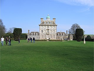
Charlton Park is a country house and estate in Wiltshire, England, 2 miles (3.2 km) northeast of the town of Malmesbury. Charlton Park House is a Grade I listed building and a leading example of the prodigy house.
Henwood is a hamlet about 3.5 miles (5.6 km) south-west of Oxford, England. Henwood is in Wootton civil parish in the Vale of White Horse District.

Great Munden is a village and civil parish in Hertfordshire, England. The parish, in the district of East Hertfordshire, spans 3,758 acres (5.872 sq mi), of which 1,895.75 acres (2.96211 sq mi) are arable land, 927.5 acres (1.4492 sq mi) are permanent grass and 97 acres (0.152 sq mi) are wood. It has a population of 477, reducing to 339 at the 2011 Census, and is situated 6 miles (9.7 km) north of the town of Ware. The village includes the church of St Nicholas, Munden Bury, and a rectory that includes the remains of a moat. Other settlements in the parish include Nasty and Levens Green. A detached portion of Little Munden was added to the parish in 1888.
Hormer was an ancient hundred of Berkshire, England. It consisted of the area immediately west of Oxford within the bend of the River Thames, all of which was transferred to Oxfordshire on 1 April 1974 in accordance with the Local Government Act 1972. It included the ancient parishes of
Swanborough was a hundred of the English county of Wiltshire, mostly lying in the centre of the county to the south of the town of Devizes. An area of the hundred reached several miles southwards into Salisbury Plain.
Malmesbury was a hundred of the English county of Wiltshire, lying in the north of the county and centring on the historic borough and market town of Malmesbury. The hundred of Malmesbury represents parishes that were within the Domesday hundreds of Cicemethorn and Sterchelee, which were held at farm by the Abbot of Malmesbury.