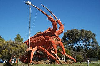
Kingston SE formerly Kingston is a town in the Australian state of South Australia located in the state's south-east coastline on the shores of Lacepede Bay. It is located about 240 kilometres southeast of the state capital of Adelaide and 138 kilometres north-west of the centre of the city of Mount Gambier. At the 2016 census, Kingston SE had a population of 1,648.
Younghusband Peninsula is a long narrow peninsula in South Australia. It separates the Coorong Channel, the Tauwitchere Channel and the Coorong which are part of the estuary of the River Murray from the Southern Ocean which including water bodies such as Encounter and Lacepede Bays. It lies entirely within the Coorong National Park. The peninsula is over 110 kilometres (68 mi) long, but less than 3 kilometres (1.9 mi) wide at its widest point. Its narrowest point is less than 350 metres (1,150 ft) wide. The Younghusband Peninsula, together with the Sir Richard Peninsula on the western side of the Murray Mouth, are the coastal dune system that forms the continental coastline from near Goolwa in the north west to about 35 kilometres north of Kingston SE in the south east. Younghusband Peninsula was named after William Younghusband, M.P.

The Kingston District Council is a local government area in the Limestone Coast, South Australia established in 1873. Kingston SE is the largest town of the district and also the seat of council.

Cape Jaffa is a headland in the Australian state of South Australia located at the south end of Lacepede Bay on the state's south east coast about 20 kilometres south west of the town centre of Kingston SE. The cape is described as being "a low sandy point" with "its sea face is about One nautical mile (1.9 km) long" and having a "wooded range rises near the S[outh] part of the cape and reaches a height of 77 metres at Mount Benson, about 8.5 nautical miles S[outh] E[ast]". A settlement known as King's Camp in some sources and as Cape Jaffa in other sources is located about 0.5 nautical miles to the north west of the cape. This settlement includes a jetty fitted with a navigation aid and a marina. The southern coastline of the cape forms part of the Bernouilli Conservation Reserve.
The Bungandidj people are an Aboriginal Australian people from the Mount Gambier region in south-eastern South Australia, and also in western Victoria. Their language is the Bungandidj language. Bungandidj was historically frequently rendered as Boandik, Buandig, or Booandik.
Maria was a brigantine built in Dublin, Ireland, and launched in 1823 as a passenger ship. On 28 June 1840, she wrecked on the Margaret Brock Reef, near Cape Jaffa in the Colony of South Australia, somewhere south-west of the current site of the town of Kingston SE, South Australia. The wreck has never been located.
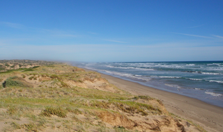
Lacepede Bay is a bay in the Australian state of South Australia located on the state's south-east coast about 140 kilometres northwest of Mount Gambier and about 240 kilometres southeast of Adelaide. It was named in 1802 by the Baudin expedition of 1800-03 after Bernard Germain de Lacépède, the French naturalist. It is one of four ‘historic bays’ located on the South Australian coast.
Butcher Gap Conservation Park is a protected area located in the Limestone Coast of South Australia overlooking Lacepede Bay about 6 kilometres south of the town of Kingston SE. The conservation park was proclaimed under the National Parks and Wildlife Act 1972 in 1990.

Cape Jaffa is a locality in the Australian state of South Australia located on the headland of Cape Jaffa on the state's south east coastline overlooking the body of water known in Australia as the Southern Ocean and by international authorities as the Great Australian Bight. It located about 245 kilometres south south-east of the state capital of Adelaide and about 19 kilometres south west of the town centre of Kingston SE.
The County of MacDonnell is one of the 49 cadastral counties of South Australia. It was proclaimed in 1857 and named for the South Australian Governor at the time of proclamation, Richard Graves MacDonnell. It is located in the upper south-east of the state from the Limestone Coast at Kingston to the Victorian border. This includes the following contemporary local government areas of the state:
Wangolina is a locality in the Australian state of South Australia located on the state’s south-east coast overlooking the body of water known in Australia as the Southern Ocean and by international authorities as the Great Australian Bight. It is about 252 kilometres south-east of the Adelaide city centre and 144 kilometres south of the centre of Mount Gambier.
West Range is a locality in the Australian state of South Australia located on the state’s south-east coast overlooking Lacepede Bay which is part of the body of water known in Australia as the Southern Ocean and by international authorities as the Great Australian Bight. It is about 232 kilometres south-east of the Adelaide city centre and 145 kilometres south of the centre of Mount Gambier.
Marcollat is a locality in the Australian state of South Australia located in the state’s Limestone Coast region about 236 kilometres (147 mi) south-east of the state capital of Adelaide and about 45 kilometres (28 mi) north of the municipal seat in Kingston SE.
The Meintangk are an indigenous Australian people, often classified as a subgroup of the Ngarrindjeri.
Blackford is a locality within the Kingston District Council in the Limestone Coast region of South Australia.
Keilira is a locality located within the Kingston District Council in the Limestone Coast region of South Australia.
Reedy Creek is a locality located within the Kingston District Council in the Limestone Coast region of South Australia. The Kingston-Naracoorte railway line opened through the area on 1 September 1876. The Reedy Creek township grew around the railway siding. The railway closed in 1987.
Tilley Swamp is a locality in the Australian state of South Australia located in the state's south-east about 199 kilometres (124 mi) south-east of the state capital of Adelaide and about 55 kilometres (34 mi) north of the municipal seat of Kingston SE. The 2016 Australian census, which was conducted in August 2016, reports that the area had a population of 27 people.
Taratap is a locality in the Australian state of South Australia located in the state's south-east about 223 kilometres (139 mi) south-east of the state capital of Adelaide and about 27 kilometres (17 mi) north-east of the municipal seat of Kingston SE.
