
The Hundred of Louth is a hundred within County of Flinders, South Australia. [1] It is on the Eyre Peninsula [2] and was proclaimed in 1857. [1] [3]
The traditional owners of the land are the Nauo peoples. [4]
The Hundred of Louth is a hundred within County of Flinders, South Australia. [1] It is on the Eyre Peninsula [2] and was proclaimed in 1857. [1] [3]
The traditional owners of the land are the Nauo peoples. [4]

The County of Flinders is one of the 49 cadastral counties of South Australia. The county covers the southern part of the Eyre Peninsula “bounded on the north by a line connecting Point Drummond with Cape Burr, and on all other sides by the seacoast, including all islands adjacent to the main land.”

Dudley Peninsula is the peninsula forming the eastern end of Kangaroo Island in the Australian state of South Australia. It was occupied by Aboriginal Australians as recently as 3,100 years BP but was found to be unoccupied by the first European explorers to visit it in the early 19th century. It was first settled by Europeans as early as the 1830s. As of 2011, it had a population of 595 people.

The County of Hindmarsh is one of the 49 cadastral counties of South Australia. It was proclaimed by Governor George Grey in 1842 and named for Governor John Hindmarsh.

County of Fergusson is a cadastral unit located in the Australian state of South Australia which spans Yorke Peninsula south of Price. It was proclaimed in 1869 by Governor Fergusson after whom the county was named.

County of Young is a cadastral unit located in the Australian state of South Australia covers land located in the state’s east on the north side of the Murray River. It was proclaimed in 1860 by Governor MacDonnell and named after his predecessor, Governor Young. It has been partially divided in the following sub-units of hundreds – Markaranka, Parcoola, Pooginook and Stuart.
County of Hore-Ruthven is a cadastral unit in the Australian state of South Australia that covers land both in the north of the Eyre Peninsula and to the peninsula's north. It was proclaimed in 1933 and was named after Alexander Hore-Ruthven, the Governor of South Australia from 1928 to 1934.
The County of Bosanquet is a cadastral unit in the Australian state of South Australia that covers land both in the north of the Eyre Peninsula and to the peninsula's north. It was proclaimed on 23 October 1913 and was named after Sir Day Hort Bosanquet, the Governor of South Australia from 1909 to 1914.

County of Le Hunte is a cadastral unit located in the Australian state of South Australia that covers land located in the centre of Eyre Peninsula. It was proclaimed in 1908 and named after George Le Hunte who was the Governor of South Australia from July 1903 to February 1909.

County of Buxton is a cadastral unit located in the Australian state of South Australia that covers land located in the centre of Eyre Peninsula. It was proclaimed in 1896 and named after Thomas Buxton who was the Governor of South Australia from 29 October 1895 to 29 March 1899. It has been divided into thirteen sub-divisions known as hundreds, with the most recent being created in 1928.
The Hundred of Cotton is a hundred in the County of Chandos, South Australia, established in 1894.

The Hundred of Bews is a hundred in the County of Chandos, South Australia, established in 1894.
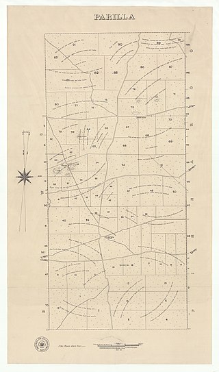
The Hundred of Parilla is a hundred within the County of Chandos, South Australia. It was established in 1894.
Peeninga is a hundred within the County of Chandos, South Australia established in 1912.
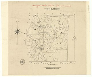
The Hundred of Perlubie is a hundred within County of Dufferin, South Australia and was proclaimed in 1895.
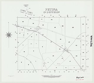
The Hundred of Petina is a hundred within County of Dufferin, South Australia and was proclaimed in 1893.

The Hundred of Nunnyah is a hundred within County of Dufferin, South Australia. and was founded in 1913.
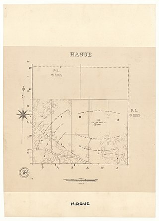
The Hundred of Hague is a hundred within County of Dufferin, South Australia and was founded in 1913.

The Hundred of Stokes is a hundred in the County of Flinders, South Australia. It was proclaimed on 21 November 1878. The name is derived from Francis William Stokes, a member of the South Australian Parliament. Its extent includes the entirety of Cockaleechie in the northwest, part of Ungarra in the northeast, part of Tumby Bay in the southeast and the northern end of Yallunda Flat in the southwest.
The Hundred of Yantanabie is a cadastral unit of hundred within County of Dufferin, South Australia.
The Hundred of Wallala is a cadastral unit of hundred in the County of Dufferin, South Australia.
| | This South Australia geography article is a stub. You can help Wikipedia by expanding it. |