
The Backstairs Passage is a strait in South Australia lying between Fleurieu Peninsula on the Australian mainland and Dudley Peninsula on the eastern end of Kangaroo Island. The western edge of the passage is a line from Cape Jervis on Fleurieu Peninsula to Kangaroo Head on Kangaroo Island. The Pages, a group of islets, lie in the eastern entrance to the strait. About 14 km wide at its narrowest, it was formed by the rising sea around 13,000 years ago, at the end of the Pleistocene era, when it submerged the land connecting what is now Kangaroo Island with the Fleurieu Peninsula. Backstairs Passage was named by Matthew Flinders whilst he and his crew on HMS Investigator were exploring and mapping the coastline of South Australia in 1802.

Cape Jaffa is a headland in the Australian state of South Australia located at the south end of Lacepede Bay on the state's south east coast about 20 kilometres south west of the town centre of Kingston SE. The cape is described as being "a low sandy point" with "its sea face is about One nautical mile (1.9 km) long" and having a "wooded range rises near the S[outh] part of the cape and reaches a height of 77 metres at Mount Benson, about 8.5 nautical miles S[outh] E[ast]". A settlement known as King's Camp in some sources and as Cape Jaffa in other sources is located about 0.5 nautical miles to the north west of the cape. This settlement includes a jetty fitted with a navigation aid and a marina. The southern coastline of the cape forms part of the Bernouilli Conservation Reserve.

Pelican Lagoon is a seawater lagoon in the Australian state of South Australia located on the north coast of Kangaroo Island about 18.7 kilometres south east of Kingscote. It was named by Matthew Flinders on 4 April 1802 after the large population of pelicans present in its waters and adjoining shorelines. Its role as fishery hatchery had been identified by the early 20th century with the result that fishing in its waters has been restricted in varying degrees.

Nepean Bay is a bay located on the north-east coast of Kangaroo Island in the Australian state of South Australia about 130 kilometres south-south-west of Adelaide. It was named by the British navigator, Matthew Flinders, after Sir Evan Nepean on 21 March 1802.
Lacepede Bay is a bay in the Australian state of South Australia located on the state's south-east coast about 140 kilometres northwest of Mount Gambier and about 240 kilometres southeast of Adelaide. It was named in 1802 by the Baudin expedition of 1800-03 after Bernard Germain de Lacépède, the French naturalist. It is one of four ‘historic bays’ located on the South Australian coast.

Penguin Island is an island in the Australian state of South Australia located in Rivoli Bay on the state's south east coast of approximately 1.5 kilometres south of Beachport. From 1878 to 1960, it was the site of an operating lighthouse. Since at least 1972, it has been part of the Penguin Island Conservation Park.
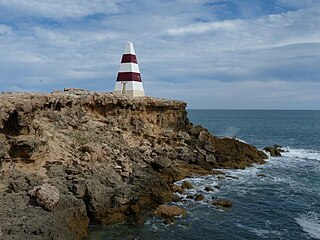
Guichen Bay, is a bay located on the south-east coast of the Australian state of South Australia about 115 kilometres northwest of the regional city of Mount Gambier and about 270 kilometres south-southeast of the state capital of Adelaide. It was named in 1802 by the Baudin expedition of 1800-03 after Luc Urbain de Bouëxic, comte de Guichen. The town of Robe is located at the southern end of the bay.
Bernouilli Conservation Reserve is a protected area located in the Australian state of South Australia in the gazetted locality of Cape Jaffa about 21 kilometres south west of the township of Kingston SE in the state's Limestone Coast region. The conservation reserve was proclaimed under the Crown Lands Act 1929 on 11 November 1993. The name is derived from Cap Bernouilli, the former name of the headland of Cape Jaffa. The conservation reserve is classified as an IUCN Category VI protected area.

Pondalowie Bay is a bay in the Australian state of South Australia located on the west coast of the south-west tip of Yorke Peninsula in Spencer Gulf about 12 kilometres west of Marion Bay. The coastline of Pondalowie Bay is both within the gazetted locality of Inneston and the Innes National Park.

Tiparra Reef is a reef located in Spencer Gulf in South Australia about 14 kilometres west of the town of Port Hughes.
Cape Northumberland is a headland in the southeast of the Australian state of South Australia. It is the southernmost point of South Australia. It is located about 3 kilometres (1.9 mi) from the town of Port MacDonnell, 28 kilometres south southwest from the municipal seat of Mount Gambier and about 393 kilometres (244 mi) southeast of the state's capital Adelaide.
West Cape is a headland located on the west coast of the Yorke Peninsula in South Australia in the gazetted locality of Inneston about 14 kilometres west of the town of Marion Bay. It is the most westerly point of Yorke Peninsula. Since 1970, the headland has been located within the Innes National Park while the waters adjoining its shoreline have been located within the Southern Spencer Gulf Marine Park since 2012. Since 1980, it has been the site of a navigation aid in the form of a lighthouse.

Corny Point is a headland located on the west coast of the Yorke Peninsula in South Australia about 37 kilometres north west of the town of Warooka. The point is described as being "a sloping rocky double projection..." where the "coast on the N[orth] side is low and sandy whereas the coast on the S[outh] side is higher than the point itself." It is the south headland of Hardwicke Bay. It was named by Matthew Flinders on 18 March 1802. The waters adjoining its shoreline are within the Southern Spencer Gulf Marine Park. Since 1882, it has been the site of a navigation aid in the form of a lighthouse.

Cape Jaffa is a locality in the Australian state of South Australia located on the headland of Cape Jaffa on the state's south east coastline overlooking the body of water known in Australia as the Southern Ocean and by international authorities as the Great Australian Bight. It located about 245 kilometres south south-east of the state capital of Adelaide and about 19 kilometres south west of the town centre of Kingston SE.
Beatrice Islets are pair of islets in the Australian state of South Australia located in Nepean Bay on the north coast of Kangaroo Island about 4 kilometres east of Kingscote. The islets and adjoining intertidal areas are notable as habitat for bird life. The islet pair has enjoyed protected area status since 1909 and since at least 1972, have been part of the Beatrice Islet Conservation Park. During either the 1960s or the 1970s, the islets were extensively damaged by an exercise to remove an infestation of South African boxthorn.
Hardwicke Bay is a bay in the Australian state of South Australia located on the west coast of Yorke Peninsula in Spencer Gulf.
Germein Bay is a bay in the Australian state of South Australia located at the northern end Spencer Gulf on the gulf's east coast to the immediate north of the city of Port Pirie. Its extent includes the port known as ‘Port Pirie’ and the former port of Port Germein. Since 2012, the majority of the bay has been within the protected area known as the Upper Spencer Gulf Marine Park.
Wangolina is a locality in the Australian state of South Australia located on the state’s south-east coast overlooking the body of water known in Australia as the Southern Ocean and by international authorities as the Great Australian Bight. It is about 252 kilometres south-east of the Adelaide city centre and 144 kilometres south of the centre of Mount Gambier.

Sleaford Bay is a bay located in the Australian state of South Australia on the southern coast of Eyre Peninsula. It was named by the British navigator, Matthew Flinders in 1802.

Margaret Brock Reef is a reef in the Australian state of South Australia located in the state's coastal waters on its south-east coast about 7 kilometres (4.3 mi) west of the headland of Cape Jaffa and about 27.2 kilometres (16.9 mi) south-west of the town of Kingston SE. It is the site of both a navigation aid which operated as a staffed lighthouse from 1872 to 1973 and as an automatic beacon onward to the present day, and a rock lobster sanctuary declared under state law in 1973. It is named after the barque Margaret Brock which was wrecked there in 1852.
