Hundred of Ripon

Last updated

Hundred of Ripon, 1894 Hundred of Ripon, 1894 (23786652925).jpg
Hundred of Ripon, 1894

The Hundred of Ripon is a cadastral hundred of the County of Robinson in South Australia, and is near Streaky Bay, South Australia on the Eyre Peninsula.

A hundred is an administrative division that is geographically part of a larger region. It was formerly used in England, Wales, some parts of the United States, Denmark, Southern Schleswig, Sweden, Finland, Estonia, and Norway. It is still used in other places, including South Australia and the Northern Territory.

County of Robinson Cadastral in South Australia

The County of Robinson is one of the 49 counties of South Australia. It was proclaimed in 1883 by Governor William Robinson who named it after himself. It lies on the north west coast of Eyre Peninsula stretching from Streaky Bay inland to include the Gawler Ranges Conservation Park at the southern cusp of the Gawler Ranges.

South Australia State of Australia

South Australia is a state in the southern central part of Australia. It covers some of the most arid parts of the country. With a total land area of 983,482 square kilometres (379,725 sq mi), it is the fourth-largest of Australia's states and territories by area, and fifth largest by population. It has a total of 1.7 million people, and its population is the second most highly centralised in Australia, after Western Australia, with more than 77 percent of South Australians living in the capital, Adelaide, or its environs. Other population centres in the state are relatively small; Mount Gambier, the second largest centre, has a population of 28,684.

History

The traditional owners of the area are the Wirangu and Nauo people, both speakers of the Wirangu language. The first European to sight the area was Dutch explorer Pieter Nuyts, in 1627 in the Gulden Zeepaard, and, in 1802, Matthew Flinders on his voyage in the Investigator. [1] Flinders named the nearby Streaky Bay.

Wirangu language language

The Wirangu language is a moribund Australian Aboriginal language traditionally spoken by the Wirangu people, living on the west coast of South Australia across a region encompassing modern Ceduna and Streaky Bay, stretching west approximately to the head of the Great Australian Bight and east to Lake Gairdner.

The Nauo (Nawu) were an indigenous Australian people of South Australia who spoke the Nauo language. They became extinct by the end of the nineteenth century.

Pieter Nuyts 3rd Governor of Formosa

Pieter Nuyts or Nuijts was a Dutch explorer, diplomat, and politician.

The first European land exploration was that of John Hill and Samuel Stephens in 1839, followed by Edward John Eyre in the same year.

John Hill was an English explorer of South Australia and part of the European exploration of Australia. Hill was the first European to see and traverse the Clare Valley.

Samuel Stephens was an English businessman who was the first Colonial Manager appointed by the South Australian Company to the new colony of South Australia.

Edward John Eyre British explorer and colonial administrator

Edward John Eyre was an English land explorer of the Australian continent, colonial administrator, and a controversial Governor of Jamaica.

Related Research Articles

Ceduna, South Australia Town in South Australia

Ceduna is a town in South Australia located on the shores of Murat Bay on the west coast of Eyre Peninsula. It lies west of the junction of the Flinders and Eyre Highways around 786 km northwest of the capital Adelaide. The port town/suburb of Thevenard lies 3 km to the west on Cape Thevenard. It is in the District Council of Ceduna, the federal Division of Grey, and the state electoral district of Flinders.

Electoral district of Flinders state electoral district of South Australia

Flinders is a single-member electoral district for the South Australian House of Assembly. It is named after explorer Matthew Flinders, who was responsible for charting most of the state's coastline. It is a 58,901 km² coastal rural electorate encompassing the Eyre Peninsula and the coast along the Nullarbor Plain, based in and around the city of Port Lincoln and contains the District Councils of Ceduna, Cleve, Elliston, Lower Eyre Peninsula, Streaky Bay and Wudinna; as well as the localities of Fowlers Bay, Nullarbor and Yalata in the Pastoral Unincorporated Area. The seat was expanded in 2002 to include a western strip of land all the way to the Western Australia border.

District Council of Streaky Bay Local government area in South Australia

The District Council of Streaky Bay is a local government area in South Australia located on the Eyre Peninsula. Streaky Bay is the main population centre of about 1200 people serving an agricultural district based on farming wheat and other cereal crops, sheep, supplemented by fishing and tourism industries. The district covers an area of 6,251.1 square kilometres with a population of 2,074 people in 2016, according to the Australian Bureau of Statistics.

Streaky Bay, South Australia Town in South Australia

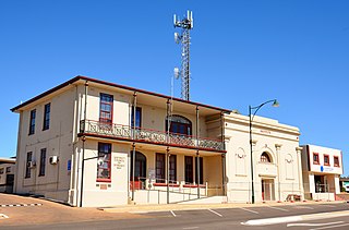
Streaky Bay is a coastal town on the western side of the Eyre Peninsula, in South Australia just off the Flinders Highway 303 km north west of Port Lincoln and 727 km by road from Adelaide. At the 2011 census, Streaky Bay recorded a population of 1,625.

The Mid West Football League is an Australian rules football competition based in the Eyre Peninsula region of South Australia, Australia. It is an affiliated member of the South Australian National Football League.

Baird Bay Town in South Australia

Baird Bay is a small fishing village located 50 kilometres south of Streaky Bay on the west coast of Eyre Peninsula in South Australia. It is situated on the east coast of a bay named Baird Bay which opens into the north end of Anxious Bay.

Perlubie, South Australia Town in South Australia

Perlubie is a locality in the Australian state of South Australia located on the west coast of Eyre Peninsula about 472 kilometres (293 mi) north-west of the state capital of Adelaide and about 24 kilometres (15 mi) north-east of the municipal seat of Streaky Bay.

Poochera, South Australia Town in South Australia

Poochera is a small grain belt town 60 km north-west of Streaky Bay on the Eyre Peninsula, South Australia.

Smoky Bay, South Australia Town in South Australia

Smoky Bay is a town and locality located in the Australian state of South Australia on the west coast of the Eyre Peninsula. Previously used as a port, the town is now a residential settlement and popular tourist destination known for its recreational fishing, with a boat ramp and jetty located in the town.

Hundred of Forrest Administrative division of South Australia

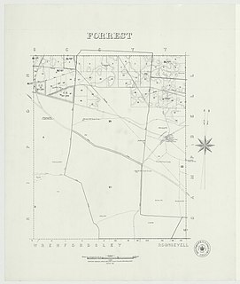
The Hundred of Forrest is a cadastral hundred of the County of Robinson in South Australia.

Hundred of Wright Administrative division in South Australia

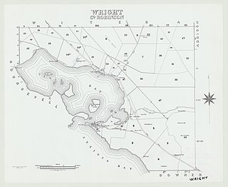
The Hundred of Wright is a cadastral hundred of County of Robinson in South Australia. It spans the west coast of the state at Venus Bay, 655 kilometres (407 mi) west of Adelaide.

Hundred of Bartlett

The Hundred of Bartlett is a cadastral hundred of South Australia located in the remote County of Way. It was created in 1889.

Hundred of Horn

The Hundred of Horn is a cadastral hundred of South Australia located in the remote County of Way.

Hundred of Campbell Administrative division of South Australia

The Hundred of Campbell is a cadastral hundred of the County of Robinson in South Australia.

Hundred of Murray Cadastral in South Australia

The Hundred of Murray is a cadastral hundred in the County of Robinson, South Australia. It occupies land midway between the towns of Streaky Bay and Poochera.

Hundred of Witera Administrative division in South Australia

The Hundred of Witera is a cadastral hundred of the County of Robinson in South Australia.

Hundred of Downer Administrative division of South Australia

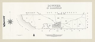
The Hundred of Downer is a cadastral hundred of County of Robinson in South Australia.

The Hundred of Wallis is a cadastral hundred of County of Robinson in South Australia.

Eba Anchorage, South Australia Suburb of District Council of Streaky Bay, South Australia

Eba Anchorage is a locality in the Australian state of South Australia located in the state's west on the eastern shore of Streaky Bay on the west coast of the Eyre Peninsula about 469 kilometres (291 mi) north-west of the state capital of Adelaide and about 14 kilometres (8.7 mi) north-east of the municipal seat of Streaky Bay.

References

  1. "Streaky Bay: Our History". District Council of Streaky Bay. 2 May 2006. Archived from the original on 29 August 2007. Retrieved 23 June 2007.