
Bedford, or the Borough of Bedford, is a unitary authority area with borough status in the ceremonial county of Bedfordshire, England. The council is based in Bedford, the borough's namesake and principal settlement, which is the county town of Bedfordshire.

Pertenhall is a small village and civil parish located in Bedfordshire, close to the borders of Cambridgeshire and Northamptonshire. Its parish council is a Quality Parish Council. It has recently published its Parish Plan which is available on the website

Bedfordshire is an English ceremonial county which lies between approximately 25 miles and 55 miles north of central London.

North East Bedfordshire was a constituency represented in the House of Commons of the Parliament of the United Kingdom from 1997 to 2024.

Tilbrook is a village and civil parish in the Huntingdonshire district of Cambridgeshire, England, approximately 10 miles (16 km) west of Huntingdon and 24 miles (39 km) north-west of Cambridge. Though administered as part of Cambridgeshire, the village historically belonged to Bedfordshire, being situated 12 miles (19 km) north of Bedford. The parish had a population of 256 in 2021.

Bletsoe is a village and civil parish in Bedfordshire, England. It is on the A6, and about eight miles north of Bedford. The village has a small park, the former site of Bletsoe Castle and a church. Nearby places are Sharnbrook, Milton Ernest, Riseley, Thurleigh, Odell, Souldrop, and Swineshead. The nearest town to Bletsoe is Bedford.

Milton Ernest is a village and civil parish in Bedfordshire, England, about 5 miles (8.0 km) north of Bedford itself. It had a population of 754 in 2001. This had risen to 761 according to the 2011 census. The village is situated on the east bank of the River Great Ouse, and is the site of Milton Ernest Hall, which was used as the United States Eighth Air Force's support command headquarters in the Second World War.

Felmersham is a small village and civil parish in the Borough of Bedford in Bedfordshire, England, on the River Great Ouse, about 7 miles (11 km) north west of Bedford. As a civil parish, it includes the hamlet of Radwell, and is sometimes known as Felmersham with Radwell, and has a population of about 800, and is circumscribed by the Great Ouse on the north, east and south. Other nearby places are Sharnbrook, Odell, Pavenham and Milton Ernest. Felmersham with Radwell was recorded in the Domesday Book of 1086 as a parish within the Hundred of Willey. John de Burnham, later Lord High Treasurer of Ireland, was parish priest here in the 1330s.

Swineshead is a village and civil parish in the Borough of Bedford in the county of Bedfordshire, England.
Eaton Socon was a rural district in Bedfordshire, England from 1894 to 1934.

North Bedfordshire is a county constituency in Bedfordshire. It returned one Member of Parliament (MP) to the House of Commons of the Parliament of the United Kingdom, elected by the first-past-the-post voting system, from the 1983 general election until it was abolished for the 1997 general election.

The Hundred of Willey is a historical land division, a hundred in the northwest corner of Bedfordshire, England. Its northwestern boundary is the county border with Northamptonshire, and its southwestern boundary the border with Buckinghamshire. Some of its parishes and settlements lay on the River Great Ouse which flows through the hundred.

Harrold is a village, civil parish and electoral ward in Bedfordshire, England, nine miles north-west of Bedford on the north bank of the River Great Ouse, close to the county boundaries of Buckinghamshire and Northamptonshire. An ancient bridge links the village with Carlton with Chellington on the south bank. Immediately to the east of the village is Odell.
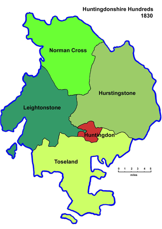
Between Anglo-Saxon times and the nineteenth century Huntingdonshire was divided for administrative purposes into 4 hundreds, plus the borough of Huntingdon. Each hundred had a separate council that met each month to rule on local judicial and taxation matters.

Between Anglo-Saxon times and the nineteenth century Bedfordshire was divided for administrative purposes into 9 hundreds, plus the borough of Bedford. Each hundred had a separate council that met each month to rule on local judicial and taxation matters.
Keysoe is a village and former civil parish, now in the parish of Bolnhurst and Keysoe, in the Bedford district, in the ceremonial county of Bedfordshire, England. In 1931 the parish had a population of 432. On 1 April 1934 the parish was abolished to form "Bolnhurst and Keysoe".

Thurleigh is a village and civil parish in the Borough of Bedford, north Bedfordshire, England, situated around 5 miles (8.0 km) north of Bedford town centre.

St Neots was a rural district in Huntingdonshire, England from 1894 to 1974, around the northern and eastern sides of the urban area of St Neots.

Little Staughton is a small village and civil parish located in the north of Bedfordshire. The parish church, All Saints, is set apart from the present village – the previous village having been abandoned following an outbreak of the Bubonic plague.
