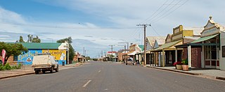
Terowie is a small town in the Mid North region of South Australia located 220 kilometres (137 mi) north of the state capital of Adelaide. It is located in the Regional Council of Goyder. Terowie retains a number of authentic and well preserved 1880s buildings, and has been declared a "historic town". It also remains a town of interest to those interested in rail history. Although now a very small town with few facilities, Terowie remains a popular destination for photographers, historians, and rail buffs. At the 2016 census, Terowie had a population of 131.

The Regional Council of Goyder is a local government area located in the Mid North region of South Australia. The council area is reliant on agriculture as a mainstay of its economy, with manufacturing and tourism also becoming prominent. The council seat lies at Burra, with a branch office situated at Eudunda.

Booborowie is a locality in South Australia. It is located 200 km (124 mi) north of Adelaide. At the 2016 census, the Booborowie district had a population of 218.
Whyte Yarcowie is a town and locality in the Australian state of South Australia. It is on the Barrier Highway between Hallett and Terowie.
The District Council of Yatala was a local government area of South Australia established in 1853 and abolished in 1868.

Terowie railway station was located on the Gawler–Peterborough line in the South Australian town of Terowie.
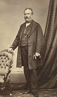
John Hallett was a businessman, pastoralist and politician in the early days of the Colony of South Australia who was implicated in the massacre of Aborigines at Mount Bryan, South Australia in the 1840s.

The District Council of Coglin was a local government area in South Australia. It came into operation on 5 January 1888 under the provisions of the District Councils Act 1887. At its inception, it comprised the Hundreds of Cavenagh, Coglin, Gumbowie, Parnaroo, Hardy, Nackara, and Paratoo. It was divided into four wards: Coglin, Gumbowie, East and North. Meetings were held alternately at Dawson and Lancelot until 1899, and thereafter at Penn.
The District Council of Yongala was a local government area in South Australia from 1883 to 1935, seated at Yongala.
The District Council of Caltowie was a local government area in South Australia, centred on the town of Caltowie and surrounding cadastral Hundred of Caltowie. It came into operation on 28 February 1878, with the first five councillors appointed by proclamation. The town and hundred had both been laid out in 1872. The council initially met in local hotels, leased private offices for a period, and met at Hornsdale Station for a year, before constructing purpose-built council offices in Charles Street, Caltowie, in 1896.

The District Council of Belalie was a local government area in South Australia. It was proclaimed on 11 November 1875, and initially comprised most of the cadastral Hundred of Belalie, including its central town of Jamestown. Jamestown itself had originally been planned to be named Belalie when surveyed; while the town had been renamed, the Belalie name was retained for the council. It was divided into five wards at its inception with one councillor each, the first councillors for each being appointed by proclamation. The South-East and South-West wards had been replaced by the Yarcowie and Yongala wards by 1893.
The District Councils Act 1887 was an act of the Parliament of South Australia. It received assent on 9 December 1887, and its provisions came into effect when proclaimed by Governor William C. F. Robinson on 5 January 1888.

The District Council of Burra Burra was a local government area in South Australia from 1935 to 1997.
The District Council of Hallett was a local government area in South Australia from 1877 to 1997.
The District Council of Booborowie was a local government area in South Australia from 1875 to 1935.
The District Council of Terowie was a local government area in South Australia from 1888 to 1935, centring on the town of Terowie.

The Hundred of Whyte is a cadastral unit of hundred located in the Mid North of South Australia in the approach to the lower Flinders Ranges. It is one of the hundreds of the County of Victoria.

County of Kimberley is a cadastral unit located in the Australian state of South Australia that covers land to the east of the Flinders Ranges about 45 kilometres (28 mi) east of the town of Peterborough. It was proclaimed in 1871 and named after John Wodehouse, 1st Earl of Kimberley, a British Secretary of State for the Colonies. It has been partially divided in the following sub-units of hundreds – Gumbowie, Hardy, Ketchowla, Parnaroo, Terowie and Wonna.
The District Council of Kapunda was a local government area in South Australia from 1866 to 1996. The Kapunda town corporation was formed a year earlier in 1865 and ultimately amalgamated into the district council.
