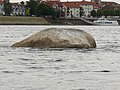
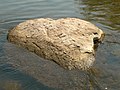
Hunger stone

Last updated

A hunger stone at the Elbe river in Decin, Czech Republic Hungerstein in Decin (21).JPG
A hunger stone at the Elbe river in Děčín, Czech Republic

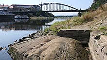
A hunger stone (German: Hungerstein) is a type of hydrological landmark common in Central Europe. Hunger stones serve as famine memorials and warnings and were erected in Germany and in ethnic German settlements throughout Europe in the 15th through 19th centuries.

Contents

These stones were embedded into a river during droughts to mark the water level as a warning to future generations that they will have to endure famine-related hardships if the water sinks to this level again. One famous example in the Elbe river in Děčín, Czech Republic, has "Wenn du mich siehst, dann weine" ("If you see me, then weep") carved into it as a warning. [1]

Many of these stones, featuring carvings or other artwork, were erected following the hunger crisis of 1816–1817 caused by the eruptions of the Tambora volcano. [2]

In 1918, a hunger stone on the bed of the Elbe River, near Děčín, became exposed during a period of low water coincident with the wartime famines of World War I. [3] Similar hunger stones in the river were uncovered again during droughts in 2018 [4] and in 2022. [5]

Known hunger stones

RiverLocationNotesPicture
Danube Budapest, right (Buda) riverside at the foot of the Gellért Hill, very close to Szabadság híd

47°29′07″N19°03′11″E / 47.485358°N 19.052978°E / 47.485358; 19.052978 (Budapest)

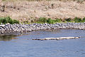
A small stone, Ínség-szikla/kő (English: Famine/Hunger cliff/stone) in the Danube, which is visible at water levels below 95 cm. The stone is located 95.75 metres above sea level. This is the last such remaining stone in the vicinity, the other ones were demolished when the river bank path was built between 1898 and 1899 Hunger-rock 2011 (5).jpg
Elbe Děčín (Tetschen)

left riverbank, near the Tyrs bridge

50°46′57″N14°12′28″E / 50.7825749°N 14.2078325°E / 50.7825749; 14.2078325 (Hungerstein Decin) [

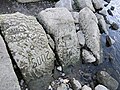
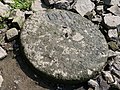
The stone measures approximately 6 m³ and is carved with different years of drought. The oldest readable carving is from 1616, with older carvings (1417 and 1473) having been wiped out by anchoring ships during the years. The stone also features the Czech sentence „Neplač holka, nenaříkej, když je sucho, pole stříkej“ (lit. "Girl, don't weep and moan, if it's dry, water the field"), probably added in 1938. [6] This hunger stone is one of the oldest hydrological landmarks in the Elbe river. Elbe Niedrigwasser Sommer 2015 - Hungerstein Decin (01-2).JPG
Elbe Těchlovice nad Labem near DěčínStone with the number 1666 (Roman: MDCLXVI)
ElbeTěchlovice near Děčín

50°42′20″N14°11′50″E / 50.705692°N 14.197161°E / 50.705692; 14.197161 (Hungerstein Techlovice)

Stone with multiple years: 1892, 1903, 1904, 1911, 1928, 1963, 2015 etc. Hungerstein in Techlovice (04).JPG
Elbe Dolní Žleb, part of Děčín

50°50′57″N14°12′58″E / 50.849096°N 14.216029°E / 50.849096; 14.216029 (Hungerstein Dolni Zleb)

Approximately ten stones with the years 1842, 1868, 1892, 1904, 2015 [7] Hungerstein in Dolni Zleb-Niedergrund Nr. 1 (2).JPG
Elbe Schmilka, near the border crossing [8]
Elbe Prossen, beneath former train conductor's houseFive years between 1928 and 2015 are carved on a skewed stone plate [8]
Elbe Königstein, near the villageYear 1681
Elbe Königstein, left riverbank near the Biela river

50°55′12″N14°04′20″E / 50.919913°N 14.072226°E / 50.919913; 14.072226 (Hungerstein Königstein)

Years 1952, 2003, 2015 Hungerstein in Konigstein (04).JPG
Elbe Stadt Wehlen, district of Pötzscha

50°56′58″N14°01′02″E / 50.949355°N 14.017302°E / 50.949355; 14.017302 (Hungerstein Wehlen)

Year 1868 [8] Wehlener Hungerstein, Potzscha (1).JPG
Elbe Pirna, district Oberposta, right riverbankAccording to the city archives, a stone with the year 1115 existed but its location is no longer known. Near Oberposta there is a stone with more than fifteen years between 1707 and 2015 carved into it Hungerstein Elbe-bei-Pirna.jpg
Elbe Dresden-Pillnitz, near the stairs of Pillnitz Castle's western sphinx

51°00′30″N13°52′09″E / 51.008237°N 13.869039°E / 51.008237; 13.869039 (Hungerstein Pillnitz)

Years: 1778, 1893, 1904, 2003, 2018. Hungerstein in Pillnitz (7).JPG
ElbeDresden-Laubegast

51°01′24″N13°50′29″E / 51.023416°N 13.841373°E / 51.023416; 13.841373 (Hungerstein Laubegast)

Years: 1893, 1899, 2003, 2015. Hungersteine in der Elbe bei Laubegaster Ufer 26, Laubegast, Dresden (3).JPG
Elbe Dresden-Tolkewitz, near Tolkewitzer Street 73

51°02′31″N13°49′04″E / 51.041975°N 13.817859°E / 51.041975; 13.817859 (Hungerstein Tolkewitz)

Year: 2016. Tolkewitzer Hungerstein, Dresden (2).JPG
ElbeDresden-Blasewitz 2 by 2 meter stone near kilometer 48.7 with years: 1930, 1943, 1947, 1950, 1963 etc.
Elbe Radebeul-Kötzschenbroda, near the steam ship port

51°06′12″N13°37′22″E / 51.103230°N 13.622900°E / 51.103230; 13.622900 (Hungerstein Radebeul-Kötzschenbroda)

Year 1811 [9] Hungerstein in Radebeul (5).JPG
Elbe Meißen Was recorded by Johann Friedrich Usinus to have been spotted in 1746 bearing the carving of the year 1654 [10]
Elbe Torgau, on the right side near the destroyed bridgeCan be seen at a water level of 50 cm or lower Torgau Elbe Hungersteine-03.jpg
Elbe Schönebeck (Elbe), near kilometer 311 on the right riverbankMeasuring 1,5 by 1,5 by 2 meters and weighing 10 tons Hungerstein Schoenebeck.jpg
Elbe Schönebeck (Elbe), museum of the city (formerly in the port)47 cm in size, year: 1904 Hungerstein im Museum Schoenebeck.jpg
Elbe Westerhüsen, part of Magdeburg

52°03′25″N11°41′10″E / 52.056913°N 11.686170°E / 52.056913; 11.686170 (Hungersteine bei Westerhüsen, Magdeburg)

see Hungerstones near Westerhülsen  [ de ] Hungersteine Westerhusen.JPG
ElbeMagdeburg, Domfelsen

52°07′22″N11°38′12″E / 52.12265°N 11.63668°E / 52.12265; 11.63668 (Domfelsen, auch Hungerfelsen, Magdeburg)

Red sandstone formation near Domfelsen, also called Hungerfelsen (lit. "hunger rock"); carved 2018 in August Domfelsen.jpg
Elbe Bleckede, near the ferry portKilometer 550. Carved with the sentence: Geht dieser Stein unter, wird das Leben wieder bunter (lit. When this stone goes under, life will become more colourful again) [11]
Moselle Traben-Trarbach-Litzig, left riverside
Mündesee Angermünde , north of the village
Rhine Worms-Rheindürkheim, near kilometer 449.4 on the left riverbankSeveral stones, years ranging from 1857 to 2009 Hungerstein im September 2003 im Rhein bei Worms-Rheindurkheim.jpg
Rhine Wageningen, LexkesveerHunger-climate stone, placed by Extinction Rebellion, text 'Climate justice, 2022'
Honger-klimaatsteen, Wageningen.jpg
Weser Near Hajen, on the left riverbankRed sandstone that was smoothed by the river Hungerstein Hajen Aufschrift von oben.jpg
Weser Würgassen 3 m³ hunger stone with the years 1800, 1840, 1842, 1847, 1850, 1857, 1858, 1859, 1865, 1874, 1876, 1881, 1911, 1922, 1934 and 1959 [12]

Common years

YearNumber of
hunger stones marked
11151
14171
14611
16161
16541
16661
16811
17072
17461
17781
17901
18002
18112
18301
18401
18423
18471
18501
18572
18581
18591
18651
18682
18741
18761
18811
18923
18933
18991
19031
19045
19112
19212
19221
19282
19301
19341
19431
19472
19501
19521
19592
19633
19711
2003 3
20091
20157
20161
2018 6
2022 ?

See also

Related Research Articles

<span class="mw-page-title-main">Transport in the Czech Republic</span>

Transport in the Czech Republic relies on several main modes, including transport by road, rail, water and air.

<span class="mw-page-title-main">Elbe</span> Major river in Central Europe

The Elbe is one of the major rivers of Central Europe. It rises in the Giant Mountains of the northern Czech Republic before traversing much of Bohemia, then Germany and flowing into the North Sea at Cuxhaven, 110 kilometres northwest of Hamburg. Its total length is 1,094 km (680 mi).

<span class="mw-page-title-main">Ústí nad Labem</span> Statutory city in Czech Republic

Ústí nad Labem is a city in the Czech Republic. It has about 92,000 inhabitants and is the capital of the Ústí nad Labem Region. It is a major industrial centre and, besides being an active river port, is an important railway junction.

<span class="mw-page-title-main">Ústí nad Labem Region</span> Region of the Czech Republic

Ústí nad Labem Region or Ústecký Region, also known as Aussiger Region, is an administrative unit of the Czech Republic, located in the north-western part of the historical land of Bohemia, and named after the capital, Ústí nad Labem. It covers the majority of the former North Bohemia province and is part of the broader area of North Bohemia.

<span class="mw-page-title-main">Děčín</span> Statutory city in Ústí nad Labem, Czech Republic

Děčín is a city in the Ústí nad Labem Region of the Czech Republic. It has about 47,000 inhabitants. It is the 7th largest municipality in the country by area. Děčín is an important traffic junction.

<span class="mw-page-title-main">2002 European floods</span> Major European floods in August 2002

In August 2002, a week of intense rainfall produced flooding across a large portion of Europe. It reached the Czech Republic, Italy, Spain, Austria, Germany, Slovakia, Hungary, Romania, Bulgaria, Croatia, Ukraine and Russia. The event killed 232 people and left €27.7 billion (US$27.115 billion) in damage. The flood was of a magnitude expected to occur roughly once a century. Flood heights unknown since St. Mary Magdalene's flood were recorded.

<span class="mw-page-title-main">Hřensko</span> Municipality in Ústí nad Labem, Czech Republic

Hřensko is a municipality and village in Děčín District in the Ústí nad Labem Region of the Czech Republic. It has about 300 inhabitants. With an elevation of 130 metres (430 ft) above sea level, it is the lowest situated municipality in the country. Located on the edge of the Bohemian Switzerland National Park, Hřensko is known for many natural monuments, especially for the Kamenice Gorge and Pravčická brána.

<span class="mw-page-title-main">Roudnice nad Labem</span> Town in Ústí nad Labem Region, Czech Republic

Roudnice nad Labem is a town in Litoměřice District in the Ústí nad Labem Region of the Czech Republic. It has about 13,000 inhabitants. The historic town centre is well preserved and is protected by law as an urban monument zone.

Albisaurus was once thought to be a genus of dinosaur, but is now thought to be a non-dinosaurian archosaur. It was first described by Antonin Fritsch, a Czech palaeontologist, in 1893, but the remains are sparse. The validity of the species cannot be proven based on the fossil remains, and it is usually marked as a nomen dubium. It lived during the Turonian-Santonian stages of the Cretaceous period.

<span class="mw-page-title-main">Jílové</span> Town in Ústí nad Labem, Czech Republic

Jílové is a town in Děčín District in the Ústí nad Labem Region of the Czech Republic. It has about 5,000 inhabitants.

<span class="mw-page-title-main">Děčín–Dresden-Neustadt railway</span>

The Děčín–Dresden railway, also called the Elbe Valley Railway is an electrified main line in Saxony and the Czech Republic. Formerly called the Saxon-Bohemian State Railway, the line is part of the Dresden to Prague route and is one of Europe's most important trunk routes (Magistralen). It runs along the Elbe Valley from Děčín via Bad Schandau and Pirna to Dresden. The first section of the line was opened in 1848 and is one of the oldest lines in Germany.

<span class="mw-page-title-main">Giant Mountains</span> Czech and Polish mountain range

The Giant Mountains, Krkonoše, or Karkonosze, are a mountain range located in the north of the Czech Republic and the south-west of Poland, part of the Sudetes mountain system. The Czech-Polish border, which divides the historic regions of Bohemia and Silesia, runs along the main ridge. The highest peak, Sněžka, is the Czech Republic's highest point with an elevation of 1,603 metres (5,259 ft).

The Děčín Weir is a planned weir and lock complex on the Elbe River, in Děčín in the Ústí nad Labem Region of the Czech Republic.

<span class="mw-page-title-main">2013 European floods</span> May-June floods in central Europe caused by heavy rainfall

Extreme flooding in Central Europe began after several days of heavy rain in late May and early June 2013. Flooding and damages primarily affected south and east German states, western regions of the Czech Republic (Bohemia), and Austria. In addition, Slovakia, Poland and Hungary were affected to a lesser extent. The flood crest progressed down the Elbe and Danube drainage basins and tributaries, leading to high water and flooding along their banks.

<span class="mw-page-title-main">Stolpersteine in Ústí nad Labem Region</span>

The Stolpersteine in the Ústecký kraj lists the Stolpersteine in the Ústí nad Labem Region in the north-west of Bohemia. Stolpersteine is the German name for stumbling blocks collocated all over Europe by German artist Gunter Demnig. They remember the fate of the Nazi victims being murdered, deported, exiled or driven to suicide.

<span class="mw-page-title-main">Stolpersteine in Mikulov, Slavkov u Brna and Znojmo</span>

The Stolpersteine in Mikulov, Slavkov u Brna and Znojmo lists the Stolpersteine in three towns of the South Moravian Region. Stolpersteine is the German name for stumbling blocks collocated all over Europe by German artist Gunter Demnig. They remember the fate of the Nazi victims being murdered, deported, exiled or driven to suicide.

<span class="mw-page-title-main">Empress Elisabeth Bridge</span> Historic bridge over the Elbe

The Empress Elisabeth Bridge was a chain bridge that spanned the Elbe between Tetschen on the east bank with Bodenbach in northern Bohemia. It was opened in 1855, named after Empress Elisabeth of Austria, and connected Tetschen to the major railroad from Dresden to Prague. The bridge was demolished in the early 1930s, but its piers were used for the modern bridge replacing it.

<span class="mw-page-title-main">Elbe Sluice</span>

The Elbe Sluice is a lock on the Elbe river in Ústí nad Labem, Czech Republic, located immediately below the Střekov Castle.

The Euroregion Elbe/Labe is one of the Euroregions with German and Czech participation. The purpose of the community of municipal interests is cross-border cooperation on a supranational level. The term is used to refer to both the organization and the geographical area of its operation.

References

  1. Damonoske, Camila (24 August 2018). "Drought In Central Europe Reveals Cautionary 'Hunger Stones' In Czech River". NPR.org. Retrieved 28 August 2018.
  2. David, Lederer (8 August 2017). "Climate and History: Hunger, Anti-Semitism, and Reform During the Tambora Crisis of 1815–1820". German History in Global and Transnational Perspective. Springer. p. 24. doi:10.1057/978-1-137-53063-9_2.
  3. "'Hunger Stone' appears". The New York Times. Associated Press. 1 August 1918. p. 1.
  4. Dockrill, Peter. "Sinister 'Hunger Stones' With Dire Warnings Have Been Surfacing in Europe". Science Alert. Archived from the original on 27 August 2018. Retrieved 28 August 2018.
  5. James, Liam (16 August 2022). "'If you see me, cry': Drought reveals 'hunger stones' in River Elbe historically used to forecast famine". The Independent. Retrieved 18 August 2022.
  6. "Labe je 24 centimetrů pod hladinou sucha, odhalilo všechny hladové kameny" [Elbe is 24 centimetres below dry level, revealing all the hunger stones]. iDNES.cz (in Czech). 25 July 2018. Retrieved 28 August 2018.
  7. "Vysychající koryto Labe odkrývá na Děčínsku hladové kameny" [Drying Elbe riverbed reveals hunger stones in the Děčín region]. iDNES.cz (in Czech). 12 September 2016. Retrieved 28 August 2018.
  8. 1 2 3 Riegel, Nancy (2 August 2018). "Die stillen Zeugen der Elbe" [The silent witnesses of the Elbe]. Sächsische Zeitung (in German). Archived from the original on 2 August 2018. Retrieved 2 August 2018.
  9. "Zeuge schlechter Zeiten" [Witness of bad times]. SZ-Online (in German). 11 August 2018. Archived from the original on 15 August 2018. Retrieved 28 August 2018.
  10. Johann Friedrich Ursinus (1790). Collektanea zur Geschichte der Stadt und des Landes Meißen [Collection on the history of the city and country of Meissen] (in German).
  11. "Bleckede: Schwindende Elbe legt Hungerstein frei" [Bleckede: Shrinking Elbe exposes hunger stone]. Deutschland News (in German). Archived from the original on 29 August 2018. Retrieved 28 August 2018.
  12. Karl Löbe (1968). Das Weserbuch. Roman eines Flusses[The Weser Book. Novel of a river] (in German). Hameln: Verlag C. W. Niemeyer. ISBN   978-3-8271-9028-4.