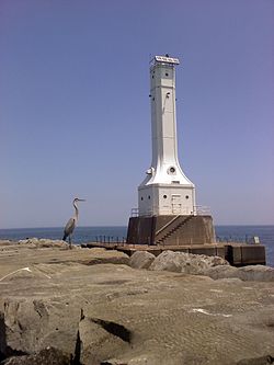
Huron Harbor Light

Last updated
Huron Harbor Light
Huron Harbor Light OH.jpg
Huron Harbor Light
Huron Harbor Light
Location Huron, Ohio, United States
Coordinates 41°24′16.59″N82°32′37.65″W / 41.4046083°N 82.5437917°W / 41.4046083; -82.5437917 Coordinates: 41°24′16.59″N82°32′37.65″W / 41.4046083°N 82.5437917°W / 41.4046083; -82.5437917
Tower
Constructed1939 [1]
Foundationcement
Height22 m (72 ft)  OOjs UI icon edit-ltr-progressive.svg
ShapeSquare
Light
First lit1936  OOjs UI icon edit-ltr-progressive.svg
Focal height24 m (79 ft)  OOjs UI icon edit-ltr-progressive.svg
Range10 nmi (19 km; 12 mi)  OOjs UI icon edit-ltr-progressive.svg
Characteristic Iso W 6s  OOjs UI icon edit-ltr-progressive.svg

The Huron Harbor Light is a lighthouse in Huron, Ohio on Lake Erie, on the west pier of the Huron Harbor.

Related Research Articles

<span class="mw-page-title-main">Lake Huron</span> One of the Great Lakes of North America

Lake Huron is one of the five Great Lakes of North America. Hydrologically, it comprises the easterly portion of Lake Michigan–Huron, having the same surface elevation as Lake Michigan, to which it is connected by the 5-mile-wide (8.0 km), 20-fathom-deep Straits of Mackinac. It is shared on the north and east by the Canadian province of Ontario and on the south and west by the U.S. state of Michigan. The name of the lake is derived from early French explorers who named it for the Huron people inhabiting the region.

<span class="mw-page-title-main">Harbor Beach, Michigan</span> City in Michigan, United States

Harbor Beach is a city in Huron County in the U.S. state of Michigan. The population was 1,703 at the 2010 census.

<span class="mw-page-title-main">Wyandot people</span> Native American ethnic group

The Wyandot people, or Wyandotte and Waⁿdát, are an Indigenous peoples of the Northeastern Woodlands. The Wyandot are Iroquoian Indigenous peoples of North America who emerged as a confederacy of tribes around the north shore of Lake Ontario with their original homeland extending to Georgian Bay of Lake Huron and Lake Simcoe in Ontario, Canada and occupying some territory around the western part of the lake.

<span class="mw-page-title-main">M-25 (Michigan highway)</span> State highway in Michigan, United States

M-25 is a state trunkline highway in the US state of Michigan. The route follows an arc-like shape closely along the Lake Huron shore of the Thumb in the eastern Lower Peninsula between Port Huron and Bay City. It serves the lakeshore resorts along Lake Huron and Saginaw Bay and generally lies within sight of the lake and the bay. All is surface road and generally scenic, except for the freeway segment near the junction with Interstate 75 (I-75) and connection into the US Highway 10 (US 10) freeway.

The Thumb is a region and a peninsula of the U.S. state of Michigan, so named because the Lower Peninsula is shaped like a mitten. The Thumb area is generally considered to be in the Central Michigan region, east of the Tri-Cities and north of Metro Detroit. The region is also branded as the Blue Water Area.

<span class="mw-page-title-main">Car float</span> Unpowered barge with railroad tracks mounted on its deck

A railroad car float or rail barge is a specialised form of lighter with railway tracks mounted on its deck used to move rolling stock across water obstacles, or to locations they could not otherwise go. An unpowered barge, it is towed by a tugboat or pushed by a towboat.

White Rock is an unincorporated community in Huron County in the U.S. state of Michigan. The community is located within Sherman Township. As an unincorporated community, White Rock has no legal autonomy, defined boundaries, or population statistics of its own. It is located at 43°42′35″N82°36′31″W, about three miles north of Forestville and about nine miles south of Harbor Beach on M-25 at the junction with White Rock Road.

<span class="mw-page-title-main">Black River (Ohio)</span> River in United States of America

The Black River is a tributary of Lake Erie, about 12 mi (19 km) long, in northern Ohio in the United States. Via Lake Erie, the Niagara River and Lake Ontario, it is part of the watershed of the St. Lawrence River, which flows to the Atlantic Ocean. The Black drains an area of 470 mi² (1217 km²).

The Sandusky Bay Conference is a high school athletic conference in the Sandusky Bay area of north central Ohio. It is affiliated with the Ohio High School Athletic Association.

<span class="mw-page-title-main">Huron Township, Erie County, Ohio</span> Township in Ohio, United States

Huron Township is one of the nine townships of Erie County, Ohio, United States. It is part of the Sandusky, Ohio metropolitan statistical area, with the city of Sandusky to the northwest. The township sits along the southwestern shoreline of Lake Erie, one of the Great Lakes. As of the 2010 census the population was 10,697, 3,548 of whom lived in the unincorporated portions of the township.

<span class="mw-page-title-main">Alpena Light</span> Lighthouse in Michigan, United States

The Alpena Light, also known as the Thunder Bay River Lighthouse or Alpena Breakwater Light, is a lighthouse on Lake Huron near Alpena, Michigan. Standing on the north breakwater of Alpena Harbor, the light marks the entrance to the Thunder Bay River from Thunder Bay. The current lighthouse, built in 1914, replaced earlier wooden structures which had been in use since 1877 and 1888. The current light is a weather-protected structure on a steel frame. It was added to the National Register of Historic Places in 2006, and the state inventory list the same year.

<i>Mataafa</i> Storm

The Mataafa Storm of 1905, was a storm that occurred on the Great Lakes on November 27–28, 1905. The system moved across the Great Basin with moderate depth on November 26 and November 27, then east-northeastward across the Great Lakes on November 28. Fresh east winds were forecast for the afternoon and evening of November 27, with storm warnings in effect by the morning of November 28. Storm-force winds and heavy snows accompanied the cyclone's passage. The storm, named after the steamship Mataafa, ended up destroying or damaging about 29 vessels, killing 36 seamen, and causing shipping losses of US$ 3.567 million on Lake Superior.

<span class="mw-page-title-main">Harbor Beach Light</span> Lighthouse in Michigan, United States

The Harbor Beach Lighthouse is a "sparkplug lighthouse" located at the end of the north breakwall entrance to the harbor of refuge on Lake Huron. The breakwall and light were created by the United States Army Corps of Engineers to protect the harbor of Harbor Beach, Michigan, which is the largest man-made freshwater harbor in the world. Harbor Beach is located on the eastern edge of the Thumb of Huron County, in the state of Michigan.

SS <i>Mataafa</i> Steam freighter that sank in Lake Superior

SS Mataafa was an American steamship that had a lengthy career on the Great Lakes of North America, first as a bulk carrier and later as a car carrier. She was wrecked in 1905 in Lake Superior just outside the harbor at Duluth, Minnesota, during a storm that was named after her. She was built as SS Pennsylvania in 1899, and renamed Mataafa when she was purchased in the same year by the Minnesota Steamship Company. After her 1905 wreck, she was raised and repaired, and served for another sixty years before being scrapped.

<span class="mw-page-title-main">Grays Reef Light</span> Lighthouse in Michigan, United States

The Grays Reef Light is a lighthouse located in northeastern Lake Michigan, 3.8 miles (6.1 km) west of Waugoshance Island in Bliss Township, Michigan. It was listed on the National Register of Historic Places in 2005.

References