
The San Francisco–Oakland Bay Bridge, commonly referred to as the Bay Bridge, is a complex of bridges spanning San Francisco Bay in California. As part of Interstate 80 and the direct road between San Francisco and Oakland, it carries about 260,000 vehicles a day on its two decks. It includes one of the longest bridge spans in the United States.

A truss bridge is a bridge whose load-bearing superstructure is composed of a truss, a structure of connected elements, usually forming triangular units. The connected elements, typically straight, may be stressed from tension, compression, or sometimes both in response to dynamic loads. There are several types of truss bridges, including some with simple designs that were among the first bridges designed in the 19th and early 20th centuries. A truss bridge is economical to construct primarily because it uses materials efficiently.

The Angus L. Macdonald Bridge is a suspension bridge crossing Halifax Harbour in Nova Scotia, Canada; it opened on April 2, 1955.
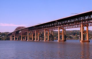
The Newburgh–Beacon Bridge is a continuous truss toll bridge that spans the Hudson River in New York State. The bridge carries Interstate 84 (I-84) and New York State Route 52 (NY 52) between Newburgh and Beacon and consists of two separate spans. The original northern span, which now carries westbound traffic, was opened on November 2, 1963, as a two-lane bridge. A second span, completed in 1980, now carries all eastbound traffic. The span provides connections to the New York State Thruway (I-87) and U.S. Route 9W (US 9W) in Newburgh and US 9 in Fishkill. The bridges includes a 2,204-foot-long (672 m) cantilever span, with a main span of 1,000 feet (300 m) and side spans of 602 feet (183 m). The total length of all spans and approaches is 7,855 feet (2,394 m) for the north span and 7,789 feet (2,374 m) for the south span. The bridges, owned by the New York State Bridge Authority, carry six lanes of traffic and approximately 65,000 vehicles per day. The bridge is officially known as the Hamilton Fish Newburgh–Beacon Bridge.

A trestle bridge is a bridge composed of a number of short spans supported by closely spaced frames. A trestle is a rigid frame used as a support, historically a tripod used to support a stool or a pair of isosceles triangles joined at their apices by a plank or beam such as the support structure for a trestle table. Each supporting frame is a bent. A trestle differs from a viaduct in that viaducts have towers that support much longer spans and typically have a higher elevation.

The Carquinez Bridge is a pair of parallel bridges spanning the Carquinez Strait at the northeastern end of San Francisco Bay. They form the part of Interstate 80 between Crockett and Vallejo, California, United States.

Lake of the Ozarks is a reservoir created by impounding the Osage River in the northern part of the Ozarks in central Missouri. Parts of three smaller tributaries to the Osage are included in the impoundment: the Niangua River, Grandglaize Creek, and Gravois Creek. The lake has a surface area of 54,000 acres (220 km2) and 1,150 miles (1,850 km) of shoreline. The main channel of the Osage Arm stretches 92 miles (148 km) from one end to the other. The total drainage area is over 14,000 square miles (36,000 km2). The lake's serpentine shape has earned it the nickname "the Missouri Dragon", which has, in turn, inspired the names of local institutions such as the Magic Dragon Street Meet.

A truss arch bridge combines the elements of the truss bridge and the arch bridge. The actual resolution of forces will depend upon the bridge' design. If no horizontal thrusting forces are generated, this becomes an arch-shaped truss which is essentially a bent beam – see moon bridge for an example. If horizontal thrust is generated but the apex of the arch is a pin joint, this is termed as a three-hinged arch. If no hinge exists at the apex, it will normally be a two-hinged arch.

The Cooper River Bridges were a pair of cantilever truss bridges that carried traffic over the Cooper River in Charleston, South Carolina, United States. The first bridge opened in 1929, a second one opened in 1966 to relieve traffic congestion. The Grace Memorial Bridge was designed and constructed by a private company known as Cooper River Bridge, Inc, and the Pearman Bridge was designed by HNTB Corporation and constructed by SCDOT.
Hurricane Deck is an unincorporated community in Camden County, Missouri, United States, on the Lake of the Ozarks. It is part of the lake's resort area, and according to one source is named for a tornado which struck the area, tornadoes once being called "hurricanes" locally.

The Milton–Madison Bridge is a continuous truss bridge that connects Milton, Kentucky and Madison, Indiana. It carries approximately 10,000 cars a day.

The Cape Girardeau Bridge was a continuous through truss bridge connecting Missouri's Route 34 with Illinois Route 146 across the Mississippi River between Cape Girardeau, Missouri, and East Cape Girardeau, Illinois. It was replaced in 2003 with the Bill Emerson Memorial Bridge.
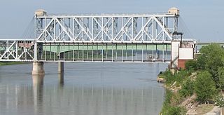
The Armour-Swift-Burlington (ASB) Bridge, also known as the North Kansas City Bridge and the LRC Bridge, is a rail crossing over the Missouri River in Kansas City, Missouri, that formerly also had an upper deck for automobile traffic.
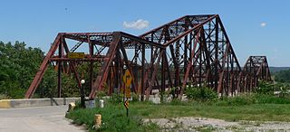
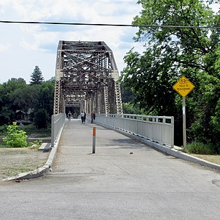
The Plattsmouth Bridge is a truss bridge over the Missouri River connecting Cass County, Nebraska, and Mills County, Iowa at Plattsmouth, Nebraska. Until 2014, it carried U.S. Highway 34 across the river.

The Miami Bridge, also known as the McDaniel Memorial Bridge, is a new concrete girder bridge that was built to replace a cantilever through truss bridge over the Missouri River at Miami, Missouri between Saline County, Missouri and Carroll County, Missouri. The Miami Bridge carries Route 41. The Miami Bridge was built in 1939, and its deck was replaced in 1983 as part of a rehabilitation project. The old bridge's main cantilever span was 474.7 feet, while the two anchor spans were each 415 feet in length, resulting in a total cantilever truss length of 1304.7 feet. There were 11 approach spans, including four Warren deck truss spans, three on the northern approach and one on the southern approach. All remaining approach spans were steel stringer (multi-beam/girder) spans. Total bridge length including approach spans is 2,071.9 feet. The bridge's deck width is 23.0 feet and it has vertical clearance of 16.5 feet.
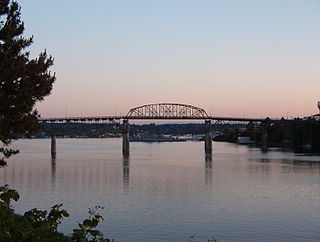
The Manette Bridge was a steel truss bridge that spanned the Port Washington Narrows in Bremerton, Washington, USA. It connected the community of Manette, Washington to downtown Bremerton. Although it is not part of a numbered state highway, it is one of four bridges specifically designated by state law to be maintained by the Washington Department of Transportation. The bridge was 82 feet (25 m) above the water, and had a horizontal clearance of 321 feet (98 m) between the piers.
The Elm Park Bridge, sometimes locally referred to as the BDI Bridge or the Ice Cream Bridge, is a steel truss bridge over the Red River in Winnipeg, Manitoba.

The Grand Glaize Bridge is the name of two girder bridges that carry U.S. Route 54 over the Grand Glaize Arm of the Lake of the Ozarks in the city of Osage Beach, Missouri.

The San Mateo–Hayward Bridge is a bridge crossing the American state of California's San Francisco Bay, linking the San Francisco Peninsula with the East Bay. The bridge's western end is in Foster City, a suburb on the eastern edge of San Mateo. The eastern end of the bridge is in Hayward. It is the longest fixed-link bridge in California and the 25th longest in the world. The bridge is owned by the state of California, and is maintained by California Department of Transportation (Caltrans), the state highway agency. Further oversight is provided by the Bay Area Toll Authority (BATA).

The Lake of the Ozarks Community Bridge is a continuous truss bridge in Lake Ozark, Missouri. Opened on May 2, 1998, the bridge connects the east and west sides of the Lake of the Ozarks. The bridge is over 2,695 ft (821 m) long and 72 ft (22 m). Construction on the bridge began in 1996 and the bridge cost over $43 million. To pay for the cost of the bridge, the bridge was established as a toll bridge with varying rates depending on the time of year. It remained a toll bridge until April 30, 2024. The bridge was the only toll road in Missouri prior to the toll being removed.

