
Guilderland is a town in Albany County, New York, United States. In the 2010 census, the town had a population of 35,303. The town is named for the Gelderland province in the Netherlands. The town of Guilderland is on the central-northwest border of the county. It is just west of Albany, the capital of the U.S. state of New York.

Rensselaerville is a town in Albany County, New York, United States. The population was 1,843 at the 2010 census. The town is named after Stephen Van Rensselaer.

Glenmont is a hamlet in the town of Bethlehem, Albany County, New York, United States. Glenmont is in the northeastern corner of the town and is a suburb of the neighboring city of Albany. It is bordered to the east by the Hudson River. Originally a farm town, today Glenmont is home to residential neighborhoods, a busy commercial corridor along Route 9W, and industry along the riverfront. It is part of the Bethlehem Central School District.
New York State Route 85 (NY 85) is a state highway in Albany County, New York, in the United States. It is 26.49 miles (42.63 km) in length and runs from CR 353 in Rensselaerville to Interstate 90 (I-90) exit 4 in Albany. It also has a loop route, NY 85A, which connects NY 85 to the village of Voorheesville. The portion of NY 85 north of NY 140 to the Bethlehem–Albany town/city line is known as the Slingerlands Bypass. From there north to I-90, the road is a limited-access, four-lane highway named the Crosstown Arterial.
New York State Route 443 (NY 443) is an east–west state highway in the Capital District of New York in the United States. The route begins at an intersection with NY 30 in the town of Schoharie and ends 33.44 miles (53.82 km) later at a junction with U.S. Route 9W (US 9W) and US 20 in the city of Albany. It ascends the Helderberg Escarpment in the towns of Berne and New Scotland. Within the town of Bethlehem and the city of Albany, NY 443 is known as Delaware Avenue.
Slingerlands is a hamlet in the town of Bethlehem, Albany County, New York, United States. It is located immediately west of Delmar and near the New Scotland town-line and south of the Albany city-limits, and is thus a suburb of Albany. The Slingerlands ZIP Code (12159) includes parts of the towns of New Scotland and Guilderland.
New York State Route 397 (NY 397) is a short state highway in New York, running from the village of Altamont to the hamlet of Dunnsville within the town of Guilderland, in Albany County. NY 397 is a two-lane highway its entire length.

The neighborhoods of Albany, New York are listed below.
Feura Bush is a hamlet in the town of New Scotland, Albany County, New York, United States. It is in the southeastern corner of the town, along the Bethlehem town-line, eight miles south of Albany. The Feura Bush ZIP Code (12067) includes parts of the town of Bethlehem. It is in the Onesquethaw Volunteer Fire Company fire protection district.
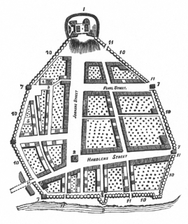
The streets of Albany, New York have had a long history going back almost 400 years. Many of the streets have changed names over the course of time, some have changed names many times. Some streets no longer exist, others have changed course. Some roads existed only on paper. The oldest streets were haphazardly laid out with no overall plan until Simeon De Witt's 1794 street grid plan. The plan had two grids, one west of Eagle Street and the old stockade, and another for the Pastures District south of the old stockade.
Lisha Kill is a hamlet in the town of Colonie, Albany County, New York, United States. Lisha Kill lies on New York Route 5 in the western section of the town. The hamlet received its name from the creek of the same name, Lisha Kill, kill being Dutch for creek or stream. The stream is also referred to as Lisha's Kill and received its name from a local legend about a Native American woman who is buried along its banks.
McKownville is a hamlet in the town of Guilderland, Albany County, New York, United States. It lies along the eastern border of the town with the city of Albany. McKownville is a heavily developed suburb of Albany and is home to many strip malls, shopping centers, and a portion of the University at Albany, SUNY and is bisected by U.S. Route 20. McKownville is named for John McKown and family, early settlers from the late 18th century.
Guilderland is a hamlet of the town of the same name in Albany County, New York, United States.
Fullers is a hamlet in the town of Guilderland, Albany County, New York, United States. The hamlet lies along U.S. Route 20.
Normansville is a former hamlet in Albany County, New York, United States. In the 19th century, Normansville was a hamlet in the town of Bethlehem. Normansville was located within and along the north and south banks of the ravine carved by the Normans Kill Creek, a tributary of the Hudson River.
Kenwood was a hamlet in the Town of Bethlehem, New York. The hamlet spanned both sides of the Normans Kill near the area where the Normans Kill flows into the Hudson River. In 1870, and again in 1910, northern portions of Kenwood were annexed by the City of Albany, New York.
South Bethlehem is a hamlet in the town of Bethlehem, Albany County, New York, United States. The hamlet sits on New York State Route 396 and lies southwest of the Selkirk Rail Yard and just north of the Coeymans town line.
New Salem is a hamlet in the town of New Scotland, Albany County, New York, United States. It is located in a valley at the foot of the Helderberg Escarpment along New York State Route 85. A local fair and car show is held every year in this small hamlet. It is also home to the town of New Scotland's community center and museum.
Clarksville is a hamlet in the town of New Scotland, Albany County, New York, United States. It is situated along Delaware Turnpike in the southern part of the town at the foot of the Helderberg Escarpment. It is the site of the Clarksville Cave and has an annual Clarksville Heritage Day and Car Show. It is in the Onesquethaw Volunteer Fire Company fire protection district.
The New Course at Albany, now the Capital Hills at Albany golf course and formerly Albany Municipal Golf Course is an 18-hole golf course located in Albany, New York.

