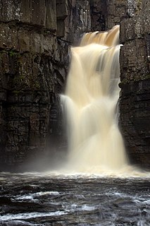
The River Tees is a river in northern England. It rises on the eastern slope of Cross Fell in the North Pennines, and flows eastwards for 85 miles (137 km) to reach the North Sea between Hartlepool and Redcar near Middlesbrough. The modern day history of the river has been tied with the industries on Teesside in its lower reaches, where it has provided the means of import and export of goods to and from the north east region. The need for water further downstream also meant that reservoirs were built in the extreme upper reaches, such as Cow Green.
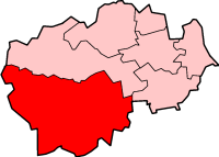
Teesdale was, from 1974 to 2009, a local government district in County Durham, England. Its council was based in Barnard Castle and it was named after the valley of the River Tees.
Startforth Rural District was a rural district in the North Riding of the historic county of Yorkshire in the Pennines of northern England.

The Farmington River is a river, 46.7 miles (75.2 km) in length along its main stem, which is located in northwest Connecticut with major tributaries extending into southwest Massachusetts. Via its longest branch, the Farmington's length increases to 80.4 miles (129.4 km), making it the Connecticut River's longest tributary by a mere 2.3 miles (3.7 km) over the major river directly to its north, the Westfield River. The Farmington River's watershed covers 609 square miles (1,580 km2). Historically, the river played an important role in small-scale manufacturing in towns along its course, but it is now mainly used for recreation and drinking water.
Teesdale is a dale, or valley, of the east side of the Pennines in County Durham, England. Large parts of Teesdale fall within the North Pennines Area of Outstanding Natural Beauty (AONB) - the second largest AONB in England and Wales. The River Tees rises below Cross Fell, the highest hill in the Pennines at 2,930 feet (890 m), and its uppermost valley is remote and high. The local climate was scientifically classified as "Sub-Arctic" and snow has sometimes lain on Cross Fell into June.

Cotherstone is a village and civil parish in the Pennine hills, in Teesdale, County Durham, England. Cotherstone lies within the historic county boundaries of the North Riding of Yorkshire, but along with the rest of the former Startforth Rural District it was transferred to County Durham for administrative and ceremonial purposes on 1 April 1974, under the provisions of the Local Government Act 1972.

Cow Green Reservoir is a 2-mile (3 km) long water reservoir built between 1967 and 1971 to supply the industries of Teesside in England.

The Croton River is a river in southern New York with three principal tributaries: the West Branch, Middle Branch, and East Branch. Their waters, all part of the New York City water supply system, join downstream from the Croton Falls Reservoir. Together, their waters and the reservoirs linked to them represent the northern half of the New York City water system's Croton Watershed.

Baldersdale is a dale, or valley, on the east side of the Pennines in England, northwest of Barnard Castle. Its principal settlements are Hury and Briscoe. Baldersdale lies within the traditional boundaries of the North Riding of Yorkshire. Under provisions of the Local Government Act 1972, it was incorporated into County Durham for administrative purposes on 1 April 1974, along with the rest of the former Startforth Rural District.
The Balder is an English river that rises on the eastern slope of Stainmore Common in the Pennine Chain and flows eastwards for about 13 miles (21 km) to the River Tees at Cotherstone.
The Ware River is a 35.4-mile-long (57.0 km) river in central Massachusetts. It has two forks, the longer of which begins in Hubbardston, Massachusetts. The Ware River flows southwest through the middle of the state, joins the Quaboag River at Three Rivers, Massachusetts, to form the Chicopee River on its way to the Connecticut River.

Grassholme Reservoir is a large reservoir in County Durham, England. It is situated in Lunedale, which is a side valley of the River Tees, about 2 miles (3.2 km) south of Middleton-in-Teesdale. It supplies water for Teesdale and Teesside and is owned by Northumbrian Water. Its main recreational use is as an angling centre.

Selset Reservoir is a reservoir in County Durham, England. It is situated in Lunedale which is a side valley of the River Tees, about 5 miles (8 km) west of Middleton-in-Teesdale. It supplies water for Teesdale and is owned by Northumbrian Water. It was built in 1960 and its main use is sailing.

Balderhead Reservoir is a reservoir in Baldersdale, County Durham, England. It is one of a chain of three reservoirs on the River Balder, a tributary of the River Tees, which it joins at Cotherstone, about 5 miles (8 km) to the east. Balderhead Reservoir was commissioned by the Tees Valley and Cleveland Water Board (TVCWB) to increase water supply to Teesdale and Teesside.

The Bear River is a tributary of the Feather River in the Sierra Nevada, winding through four California counties: Yuba, Sutter, Placer, and Nevada. About 73 miles (117 km) long, the river flows generally southwest through the Sierra then west through the Central Valley, draining a narrow, rugged watershed of 295 square miles (760 km2).

Blackton Reservoir is a reservoir in County Durham, England. It is situated in Baldersdale, about 4 miles (7 km) west of Cotherstone, where the River Balder joins the River Tees.
Botany Hill, formerly known as Botany Quarry, is a Site of Special Scientific Interest in the Teesdale district of south-west County Durham, England. It occupies a position on both sides of How Gill, just under 1 km north of the village of Hury, in Baldersdale.
Mere Beck Meadows, formerly known as Willoughby Hall Meadows, is a Site of Special Scientific Interest in the Teesdale district of County Durham, England. It consists of three hay meadows, situated on the south side of Hury Reservoir, immediately below the Blackton Reservoir dam.
Northumbrian Water Limited is a water company in the United Kingdom, providing mains water and sewerage services in the English counties of Northumberland, Tyne and Wear, Durham and parts of North Yorkshire, and also supplying water as Essex and Suffolk Water. It is a wholly owned subsidiary of Northumbrian Water Group.

