Related Research Articles
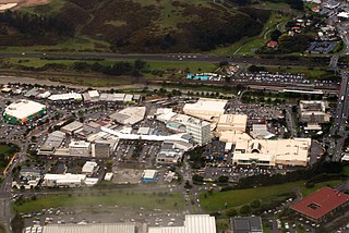
Porirua, a city in the Wellington Region of the North Island of New Zealand, is one of the four cities that constitute the Wellington metropolitan area. The name 'Porirua' is a corruption of 'Pari-rua', meaning "the tide sweeping up both reaches". It almost completely surrounds Porirua Harbour at the southern end of the Kāpiti Coast. As of June 2022, Porirua had a population of 60,200.


The Kāpiti Coast District is a local government district of the Wellington Region in the lower North Island of New Zealand, 50 km north of Wellington City. The district is named after Kapiti Island, a prominent island 5 kilometres (3.1 mi) offshore.

Wellington City Council is a territorial authority in New Zealand, governing the city of Wellington, the country's capital city and third-largest city by population, behind Auckland and Christchurch. It consists of the central historic town and certain additional areas within the Wellington metropolitan area, extending as far north as Linden and covering rural areas such as Mākara and Ohariu. The city adjoins Porirua in the north and Hutt City in the north-east. It is one of nine territorial authorities in the Wellington Region.

Tawa is the northernmost suburb within the Wellington city boundary, located roughly 15 km north of Wellington's CBD between Churton Park and Porirua in the North Island of New Zealand. It takes its name from the broadleaf tree, which was once prolific throughout the area, although its most famous tree is the Bucket Tree, a large macrocarpa with the topiary of an upside-down bucket. Tawa is also known for its large number of churches, representing a wide range of Christian denominations.
Wellington Regional Council, branded as Greater Wellington Regional Council, is the regional council overseeing the Wellington Region of New Zealand's lower North Island. It is responsible for public transport under the brand Metlink, environmental and flood protection, and the region's water supply. As of 2023, it is the majority owner of CentrePort Wellington with a 77% shareholding.
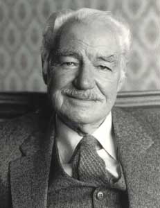
Whitford James Richard Brown was the foundation mayor of Porirua City, a city in the Wellington Region of New Zealand, for 21 years from 1962 to 1983. Previously, Porirua was part of what was then called the Makara County Council. In 1961, the Local Government Commission deemed that Porirua should become a borough. The region had its first elections in October 1962, and, Brown was elected mayor.

Kenneth Francis Gray was an international rugby union player from New Zealand. He represented New Zealand in 24 international games, playing lock and later prop forward.
Lower Hutt is a city in the Wellington Region of New Zealand. Administered by the Hutt City Council, it is one of the four cities that constitute the Wellington metropolitan area.

Belmont Regional Park is a regional park located between Lower Hutt and Porirua, in the Wellington Region at the southern end of New Zealand's North Island. It is administered by Wellington Regional Council.
John Brian Burke is a former mayor of Porirua City, Wellington Region, New Zealand. Prior to his time as mayor from 1983 to 1998, he served 12 years as a city councillor with six years from 1977 to 1983 as deputy mayor. After a 15-year absence from the city council, in 2013 and 2016 he stood for election as a city councillor in the eastern ward, and was elected. In September 2019 Burke announced he would not be seeking re-election, ending continuous public office which began in 1971.
The Wellington local elections, 2010 are part of the 2010 New Zealand local elections, to elect members to sub-national councils and boards. The Wellington elections cover one regional council, eight territorial authority councils, three district health boards, and various community boards and licensing trusts.

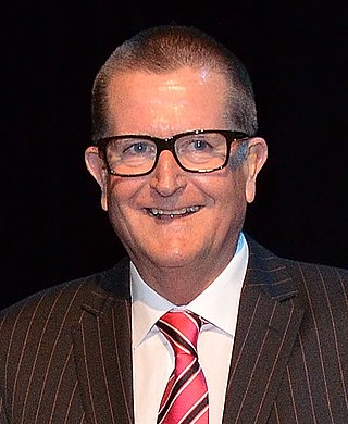
The Mayor of Porirua is the head of the municipal government of Porirua, New Zealand, and presides over the Porirua City Council. The mayor is directly elected using the single transferable vote electoral system. There have been six mayors since the establishment of the borough council in 1962: the current mayor is Anita Baker, who was elected in October 2019.
The Mayor of Upper Hutt is the head of the municipal government of Upper Hutt, New Zealand, and presides over the Upper Hutt City Council. The mayor is directly elected using a First Past the Post electoral system. The Upper Hutt Town Board had seven chairmen, with the role regarded as the predecessor role of mayor. The Upper Hutt Borough Council was proclaimed in 1926, and with that, the role of mayor was introduced. In 1966, Upper Hutt became a city council. The current mayor, Wayne Guppy, is the eleventh since the role was created in 1926, and he was first elected in 2001.
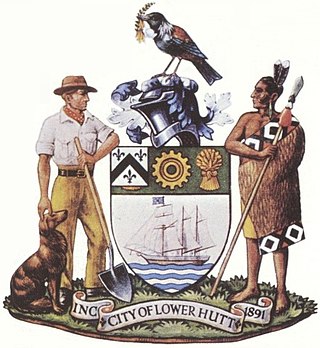
The city of Lower Hutt, New Zealand, was first proclaimed a borough on 1 February 1891. Prior to this it had been part of Hutt County, initially as a Roads Board and from 1881 as a Town Board.
The Haywards–Plimmerton Line was a railway development proposed several times between 1879 and the 1960s to connect the Hutt Valley and Porirua areas of Wellington via Haywards.
The Hutt City Council is a territorial authority in New Zealand, governing the city of Lower Hutt. Lower Hutt is the country's seventh largest city. The city borders Porirua to the north, Upper Hutt to the northeast, South Wairarapa District to the east, and Wellington to the southwest and west. It is one of nine territorial authorities in the Wellington Region.
The 2022 Wellington local elections were held on 8 October 2022 as part of the wider 2022 New Zealand local elections to elect members to sub-national councils and boards. The Wellington elections cover one regional council, eight territorial authorities, and various community boards and licensing trusts.
The 1989 Lower Hutt mayoral election was part of the New Zealand local elections held that same year. The elections were held for the role of Mayor of Lower Hutt plus other local government positions including fifteen city councillors, also elected triennially. The polling was conducted using the standard first-past-the-post electoral method.
References
- ↑ Hutt County Council The Cyclopedia of New Zealand [Wellington Provincial District], The Cyclopedia Company, Limited, 1897, Wellington. Retrieved from The New Zealand Electronic Text Centre on 24 January 2011.
- ↑ Maclean, Chris (1 August 2015). "The break-up of Hutt County". Te Ara - the Encyclopedia of New Zealand. Retrieved 11 November 2022.