Related Research Articles

Khyber Pakhtunkhwa, formerly known as North West Frontier Province (NWFP), is a province of Pakistan. Located in the northwestern region of the country, Khyber Pakhtunkhwa is the fourth largest province of Pakistan by land area and the third-largest province by population. It is bordered by the Pakistani provinces of Balochistan to the south, Punjab to the south-east, the territory of Gilgit-Baltistan to the north and north-east, Islamabad Capital Territory to the east and Azad Kashmir to the north-east. It shares an international border with Afghanistan to the west. Khyber Pakhtunkhwa has a varied landscape ranging from rugged mountain ranges, valleys, plains surrounded by hills, undulating submontane areas and dense agricultural farms.

Badakhshan is a historical region comprising parts of modern-day north-eastern Afghanistan, eastern Tajikistan, and Taxkorgan Tajik Autonomous County in China. Badakhshan Province is one of the 34 provinces of Afghanistan. Much of historic Badakhshan lies within Tajikistan's Gorno-Badakhshan Autonomous Region in the southeastern part of the country. The music of Badakhshan is an important part of the region's cultural heritage.

The Great Game was a rivalry between the 19th-century British and Russian empires over influence in Central Asia, primarily in Afghanistan, Persia, and Tibet. The two colonial empires used military interventions and diplomatic negotiations to acquire and redefine territories in Central and South Asia. Russia conquered Turkestan, and Britain expanded and set the borders of British colonial India. By the early 20th century, a line of independent states, tribes, and monarchies from the shore of the Caspian Sea to the Eastern Himalayas were made into protectorates and territories of the two empires.
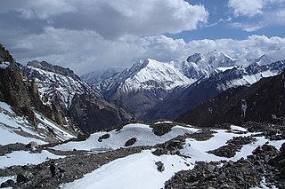
The Pamir Mountains are a range of mountains between Central Asia and South Asia. They are located at a junction with other notable mountains, namely the Tian Shan, Karakoram, Kunlun, Hindu Kush and the Himalaya mountain ranges. They are among the world's highest mountains.
Dargai is one of the tehsils of Malakand District in Pakistan's northwestern Khyber Pakhtunkhwa province. It located on the main highway from Peshawar to Swat, Dir and Chitral.

William Moorcroft was an English veterinarian and explorer employed by the East India Company. Moorcroft travelled extensively throughout the Himalayas, Tibet and Central Asia, eventually reaching Bukhara, in present-day Uzbekistan.

Akhūnd Abdul Ghaffūr was a prominent religious saint and founder of the State of Swat. The city of Saidu Sharif, that serves as the administrative capital of Swat District, is named after him. His descendants ruled over Swat between 1876 and 1969 with the title of Wāli of Swāt.

Dir is a region in northwestern Pakistan in the Khyber Pakhtunkhwa, in the foothills of the Himalayas. Before the independence of Pakistan, Dir was a princely state, and it remained so until 1969 when it was abolished by a presidential declaration, and the Dir District was created the following year. The area covers 5,280 square kilometres. In 1996 Dir district was officially divided into Lower Dir District and Upper Dir District.

Lieutenant-Colonel Thomas George Montgomerie FRS (1830–1878) was a British surveyor who participated in the Great Trigonometric Survey of British India as a lieutenant in the 1850s. He was the person to label K2, the second highest mountain in the world, the K standing for Karakoram.

The Battle of Ghazni took place in the city of Ghazni in central Afghanistan on Tuesday, July 23, 1839, during the First Anglo-Afghan War.
The Malakand Levies is a paramilitary force in the Pakistani province of Khyber Pakhtunkhwa, Malakand Division. It operates as the primary law enforcement agency tasked with maintaining law and order within the division. The force has its origins back in the days of the British Raj, and has continued to function for over a century.

The Chitral Expedition was a military expedition in 1895 sent by the British authorities to relieve the fort at Chitral, which was under siege after a local coup following the death of the old ruler. An intervening British force of about 400 men was besieged in the fort until it was relieved by two expeditions, a small one from Gilgit and a larger one from Peshawar.

Aman ul-Mulk was the Mehtar of Chitral, Ghizer, Yasen and Ishkoman and Suzerain of Kafiristan. He ruled the State of Chitral from 1857 to 1892. His rule saw Chitral reach its territorial peak, extending from Ishkamun in Gilgit Agency to Asmar in Afghanistan. His death led to the Siege of Chitral, an instance of high drama which goes down in the annals of British India as an epic of enormous courage and determination.
His Highness Sir Nasir ul-Mulk KCIE was the eldest son of Mehtar Shuja ul-Mulk, who succeeded him in 1936. He ruled the princely state of Chitral from 1936 to 1943.

In the 16th century, the Tsardom of Russia embarked on a campaign to expand the Russian frontier to the east. This effort continued until the 19th century under the Russian Empire, when the Imperial Russian Army succeeded in conquering all of Central Asia. The majority of this land became known as Russian Turkestan—the name "Turkestan" was used to refer to the area due to the fact that it was and is inhabited by Turkic peoples, excluding the Tajiks, who are an Iranian ethnicity. Upon witnessing Russia's absorption of the various Central Asian realms, the British Empire sought to reinforce India, triggering the Great Game, which ended when both sides eventually designated Afghanistan as a neutral buffer zone.

William Watts McNair was a British surveyor, the first British explorer of Kafiristan.
The Duhamel plan was a proposed Russian invasion of British-ruled India during the Crimean War, a war in which Russia was fighting Britain, France and the Ottoman Empire. The plan was drawn up by General Alexander Osipovich Duhamel and proposed to Tsar Nicholas I in 1854. Duhamel proposed five alternative routes but his preference was to march through Persia and Afghanistan and invade British India through the Khyber Pass. The plan would have required the support of the Afghans and Persians.

Chitral or Chitrāl was a princely state in alliance with British India until 1947, then a princely state of Pakistan in 1972. The area of the state now forms the Upper and Lower Chitral Districts of the NWFP, Pakistan.
Abdul Mejid was a Kabuli mullah and merchant who explored Central Asia on behalf of the British Empire.
References
- ↑ Derek J. Waller. The Pundits : British exploration of Tibet and Central Asia. Lexington, Kentucky: University Press of Kentucky, 1990.pp. 84-94
- ↑ T. G. Montgomerie, "A Havildar's Journey through Chitral to Faizabad in 1870," Journal of the Royal Geographical Society. vol. 42, 1872, pp. 180–201