
A levee, dike, dyke, embankment, floodbank, or stop bank is a structure used to keep the course of rivers from changing and to protect against flooding of the area adjoining the river or coast. It is usually earthen and often runs parallel to the course of a river in its floodplain or along low-lying coastlines.

Placer mining is the mining of stream bed deposits for minerals. This may be done by open-pit mining or by various surface excavating equipment or tunneling equipment.
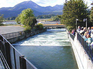
A fish ladder, also known as a fishway, fish pass, fish steps, or fish cannon, is a structure on or around artificial and natural barriers to facilitate diadromous fishes' natural migration as well as movements of potamodromous species. Most fishways enable fish to pass around the barriers by swimming and leaping up a series of relatively low steps into the waters on the other side. The velocity of water falling over the steps has to be great enough to attract the fish to the ladder, but it cannot be so great that it washes fish back downstream or exhausts them to the point of inability to continue their journey upriver.

Hydraulic mining is a form of mining that uses high-pressure jets of water to dislodge rock material or move sediment. In the placer mining of gold or tin, the resulting water-sediment slurry is directed through sluice boxes to remove the gold. It is also used in mining kaolin and coal.

Dredging is the excavation of material from a water environment. Possible reasons for dredging include improving existing water features; reshaping land and water features to alter drainage, navigability, and commercial use; constructing dams, dikes, and other controls for streams and shorelines; and recovering valuable mineral deposits or marine life having commercial value. In all but a few situations the excavation is undertaken by a specialist floating plant, known as a dredger.
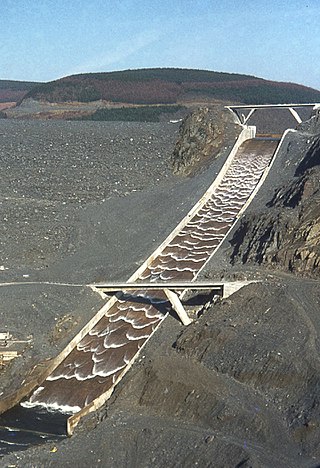
A spillway is a structure used to provide the controlled release of water downstream from a dam or levee, typically into the riverbed of the dammed river itself. In the United Kingdom, they may be known as overflow channels. Spillways ensure that water does not damage parts of the structure not designed to convey water.

Soil mechanics is a branch of soil physics and applied mechanics that describes the behavior of soils. It differs from fluid mechanics and solid mechanics in the sense that soils consist of a heterogeneous mixture of fluids and particles but soil may also contain organic solids and other matter. Along with rock mechanics, soil mechanics provides the theoretical basis for analysis in geotechnical engineering, a subdiscipline of civil engineering, and engineering geology, a subdiscipline of geology. Soil mechanics is used to analyze the deformations of and flow of fluids within natural and man-made structures that are supported on or made of soil, or structures that are buried in soils. Example applications are building and bridge foundations, retaining walls, dams, and buried pipeline systems. Principles of soil mechanics are also used in related disciplines such as geophysical engineering, coastal engineering, agricultural engineering, and hydrology.

The Fort Peck Dam is the highest of six major dams along the Missouri River, located in northeast Montana in the United States, near Glasgow, and adjacent to the community of Fort Peck. At 21,026 feet (6,409 m) in length and over 250 feet (76 m) in height, it is the largest hydraulically filled dam in the United States, and creates Fort Peck Lake, the fifth largest artificial lake in the U.S., more than 130 miles (210 km) long, 200 feet (61 m) deep, and it has a 1,520-mile (2,450 km) shoreline which is longer than the state of California's coastline. It lies within the Charles M. Russell National Wildlife Refuge. The dam and the 134-mile-long (216 km) lake are owned and operated by the U.S. Army Corps of Engineers and exist for the purposes of hydroelectric power generation, flood control, and water quality management.
The Yuba Goldfields, also known as the Hammonton dredge field, is the largest gold dredge field in California. Located along the Yuba River approximately 6–12 miles (10–20 km) upstream of the town of Marysville, in Yuba County, the Hammonton dredge field was actively dredged for gold from 1904 to 1968. In total, more than one billion cubic yards of river sediment and lesser hydraulic mining debris was dredged to produce an estimated 5.14 million ounces of gold. The goldfields are noted for their otherworldly appearance, filled with roughly linear mounds of gravels, ravines, streams and turquoise-colored pools of water. From the air, the goldfields are said to resemble intestines.
Internal erosion is the formation of voids within a soil caused by the removal of material by seepage. It is the second most common cause of failure in levees and one of the leading causes of failures in earth dams, responsible for about half of embankment dam failures.

An embankment dam is a large artificial dam. It is typically created by the placement and compaction of a complex semi-plastic mound of various compositions of soil or rock. It has a semi-pervious waterproof natural covering for its surface and a dense, impervious core. This makes the dam impervious to surface or seepage erosion. Such a dam is composed of fragmented independent material particles. The friction and interaction of particles binds the particles together into a stable mass rather than by the use of a cementing substance.
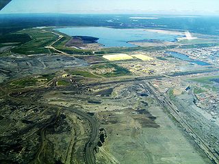
The Syncrude Tailings Dam, impounding the Mildred Lake Settling Basin (MLSB), is an embankment dam that is, by volume of construction material, the largest earth structure in the world in 2001. It is located 40 km (25 mi) north of Fort McMurray, Alberta, Canada, at the northern end of the Mildred Lake lease area owned by Syncrude Canada Ltd. The dam and the tailings reservoir within it are constructed and maintained as part of ongoing operations by Syncrude in extracting oil from the Athabasca oil sands. Other tailings dams constructed and operated in the same area by Syncrude include the Southwest Sand Storage (SWSS), which is the third largest dam in the world by volume of construction material after the Tarbela Dam.

Hushing is an ancient and historic mining method using a flood or torrent of water to reveal mineral veins. The method was applied in several ways, both in prospecting for ores, and for their exploitation. Mineral veins are often hidden below soil and sub-soil, which must be stripped away to discover the ore veins. A flood of water is very effective in moving soil as well as working the ore deposits when combined with other methods such as fire-setting.

A check dam is a small, sometimes temporary, dam constructed across a swale, drainage ditch, or waterway to counteract erosion by reducing water flow velocity. Check dams themselves are not a type of new technology; rather, they are an ancient technique dating from the second century AD. Check dams are typically, though not always, implemented in a system of several dams situated at regular intervals across the area of interest.

Lake Cachi is an artificial lake in central Costa Rica created by the Cachí Dam, an arch dam north of Tapantí National Park, to the east-southeast of Cartago in Cartago Province. The main town is Cachí, away from the east bank of the lake. Built in the 1970s, it was one of the first hydroelectric projects in Costa Rica. It has an installed capacity of 102 MW with three units of 34 MW capacity each.

Dredge No. 4 is a wooden-hulled bucketline sluice dredge that mined placer gold on the Yukon River from 1913 until 1959. It is now located along Bonanza Creek Road 13 kilometres (8.1 mi) south of the Klondike Highway near Dawson City, Yukon, where it is preserved as one of the National Historic Sites of Canada. It is the largest wooden-hulled dredge in North America.
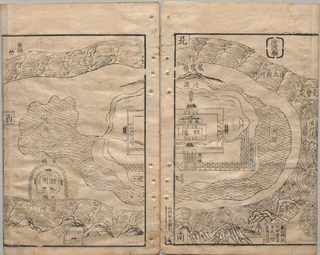
Pan Jixun (1521–1595), courtesy name Shiliang and pseudonym Yinchuan, was a Chinese scholar-bureaucrat and hydrologist of the Ming dynasty. He was noted for his monograph Overview of River Management.
The Oesterdam is a compartmentalisation dam in The Netherlands, situated between Tholen and South Beveland in the eastern part of the Eastern Scheldt. The dam, with a length of 10.5 kilometres, is the longest structure built for the Delta Works. The Oesterdam was necessitated, like the Philipsdam, after the decision was taken to close off the Eastern Scheldt with a storm surge barrier, rather than a solid dam.
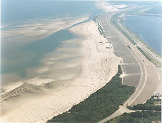
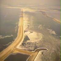
In coastal and environmental engineering, the closure of tidal inlets entails the deliberate prevention of the entry of seawater into inland areas through the use of fill material and the construction of barriers. The aim of such closures is usually to safeguard inland regions from flooding, thereby protecting ecological integrity and reducing potential harm to human settlements and agricultural areas.
