Related Research Articles

Hydrology is the scientific study of the movement, distribution, and management of water on Earth and other planets, including the water cycle, water resources, and drainage basin sustainability. A practitioner of hydrology is called a hydrologist. Hydrologists are scientists studying earth or environmental science, civil or environmental engineering, and physical geography. Using various analytical methods and scientific techniques, they collect and analyze data to help solve water related problems such as environmental preservation, natural disasters, and water management.

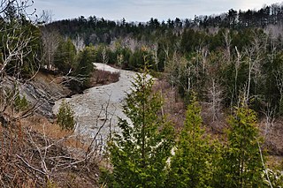
The Oak Ridges Moraine is an ecologically important geological landform in the Mixedwood Plains of south-central Ontario, Canada. The moraine covers a geographic area of 1,900 square kilometres (730 sq mi) between Caledon and Rice Lake, near Peterborough. One of the most significant landforms in southern Ontario, the moraine gets its name from the rolling hills and river valleys extending 160 km (99 mi) east from the Niagara Escarpment to Rice Lake, formed 12,000 years ago by advancing and retreating glaciers during the last glaciation period. Below the approximately 200 metre thick glacial derived sediments of the moraine lies thick bedrock successions of Precambrian rocks and up to 200 metres of Ordovician aged rock, capped by a regional unconformity of erosion and non-deposition to the Quaternary period. Rivers and lakes scatter the landscape and are important for creating habitat for the rich diversity of species of animals, trees and shrubbery. These are also the supply of fresh water to aquifers in the moraine through complex subterranean connections. Construction development nearby, and with expansion of communities around the moraine in need of potable water, it is a contested site in Ontario, since it stands in the path of major urban development. Conservation of the moraine is thus an important step for keeping aquifers in a safe drinkable condition while also protecting the natural ecosystems surrounding and within the moraine. This region has been subject to multiple decades of scientific research to study the origins of formation, and how early communities used the land. A larger focus currently is how to source potable water without removing the aquifer entirely.

The Rouge River is a river in Markham, Pickering, Richmond Hill and Toronto in the Greater Toronto Area of Ontario, Canada. The river flows from the Oak Ridges Moraine to Lake Ontario at the eastern border of Toronto, and is the location of Rouge Park, the only national park in Canada within a municipality. At its southern end, the Rouge River is the boundary between Toronto and southwestern Pickering in the Regional Municipality of Durham.
Fossil water or paleowater is an ancient body of water that has been contained in some undisturbed space, typically groundwater in an aquifer, for millennia. Other types of fossil water can include subglacial lakes, such as Antarctica's Lake Vostok, and even ancient water on other planets.
The politics of the Oak Ridges Moraine in southern Ontario, Canada, have centred on the question of how to preserve this extensive natural resource that is increasingly threatened by human modification. Although preservation of the moraine was first suggested in the 1940s, and intermittently over the subsequent fifty years, it was not until 1991 that the issue achieved prominence in political discourse. For the ensuing decade, use of the moraine was hotly contested between the interests of local residents, developers and environmentalists.
The Waterloo Moraine is a landform and sediment body that was created as a moraine in the Regional Municipality of Waterloo, in Ontario, Canada. It covers a large portion of the cities of Waterloo and Kitchener and the township of Wilmot, and some parts of the townships of Wellesley and North Dumfries. About 90% of the water supply of the Regional Municipality of Waterloo is derived from groundwater of the Waterloo Moraine aquifer system.

The Edwards Aquifer is one of the most prolific artesian aquifers in the world. Located on the eastern edge of the Edwards Plateau in the U.S. state of Texas, it is the source of drinking water for two million people, and is the primary water supply for agriculture and industry in the aquifer's region. Additionally, the Edwards Aquifer feeds the Comal and San Marcos Springs, provides springflow for recreational and downstream uses in the Nueces, San Antonio, Guadalupe, and San Marcos river basins, and is home to several unique and endangered species.

The Greenbelt is a protected area of green space, farmland, forests, wetlands, and watersheds, located in Southern Ontario, Canada. It surrounds a significant portion of the Golden Horseshoe.

Groundwater recharge or deep drainage or deep percolation is a hydrologic process, where water moves downward from surface water to groundwater. Recharge is the primary method through which water enters an aquifer. This process usually occurs in the vadose zone below plant roots and is often expressed as a flux to the water table surface. Groundwater recharge also encompasses water moving away from the water table farther into the saturated zone. Recharge occurs both naturally and through anthropogenic processes, where rainwater and or reclaimed water is routed to the subsurface.

Overdrafting is the process of extracting groundwater beyond the equilibrium yield of an aquifer. Groundwater is one of the largest sources of fresh water and is found underground. The primary cause of groundwater depletion is the excessive pumping of groundwater up from underground aquifers.

The Lake Simcoe Region Conservation Authority is a conservation authority established in 1951, and is among the oldest in the Canadian province of Ontario.
The Toronto ravine system is a distinctive feature of the city's geography, consisting of a network of deep ravines, which forms a large urban forest that runs through most of Toronto. The ravine system is the largest in any city in the world, with the Ravine and Natural Feature Protection Bylaw protecting approximately 110 square kilometres (42 sq mi) of public and privately-owned land. The ravine system has been presented as a central characteristic of the city, with the size of the ravine system leading Toronto to be described as "a city within a park".
Geographic information systems (GISs) have become a useful and important tool in the field of hydrology to study and manage Earth's water resources. Climate change and greater demands on water resources require a more knowledgeable disposition of arguably one of our most vital resources. Because water in its occurrence varies spatially and temporally throughout the hydrologic cycle, its study using GIS is especially practical. Whereas previous GIS systems were mostly static in their geospatial representation of hydrologic features, GIS platforms are becoming increasingly dynamic, narrowing the gap between historical data and current hydrologic reality.
The Galena River is an 8.5-mile-long (13.7 km) stream in northern Indiana in the United States. It rises in the northeast corner of Springfield Township, about 5 miles (8 km) north of LaPorte in LaPorte County and flows northeast. Just after it crosses the state boundary into Three Oaks Township in Berrien County, Michigan, it is joined from the east by Spring Creek to form the South Branch Galien River. After becoming the Galien River in Michigan, the river ultimately flows to Lake Michigan in New Buffalo.

The Santa Clara valley aquifer is a groundwater aquifer located in the southern San Francisco Bay Area. The geology of the Santa Clara valley aquifer consists of a complex stratigraphy of permeable and impermeable units. Management of aquifer resources is associated with the Santa Clara Valley Water District.
The Oro Moraine is a glacial moraine in Simcoe County, Ontario, Canada. The moraine covers 141 square kilometres (54 sq mi) north of Barrie, Ontario. The moraine drains into Georgian Bay on Lake Huron, and the smaller Lake Simcoe.

The Toronto waterway system comprises a series of natural and man-made watercourses in the Canadian city of Toronto. The city is dominated by a large river system spanning most of the city including the Don River, Etobicoke Creek, Highland Creek, Humber River, Mimico Creek and Rouge River.
Borrego Valley Groundwater Basin, located in the very southern region of California, is one of the driest basins in the state. With climate change predicted to have strong effects into foreseeable future, the region is viewed with a skepticism in the sustainable use of water at current rates of consumption. Both natural and man-made geographic divisions within this basin allow for a closer inspection of the various management techniques implemented throughout the years, and provide a basis for what may be pursued for an uncertain future.
Groundwater in Nigeria is widely used for domestic, agricultural, and industrial supplies. The Joint Monitoring Programme for Water Supply and Sanitation estimate that in 2018 60% of the total population were dependent on groundwater point sources for their main drinking water source: 73% in rural areas and 45% in urban areas. The cities of Calabar and Port Harcourt are totally dependent on groundwater for their water supply.

Santa Ana water resource basin is one of three hydrologic basins within the Southern California Coastal water resource subregion and is one of approximately 2,200 water resource basins in the United States hydrologic unit system. The Santa Ana water resource basin is a third-level subdivision of the United States hydrologic unit system.
References
- ^ STORM Coalition: The Moraine
- ^ National Research Council of Canada - Hydrogeology of the Oak Ridges Moraine aquifer system: implications for protection and management from the Duffins Creek watershed
- ^ Achieving Ecological Integrity on the Oak Ridges Moraine: Towards Ecologically Relevant Water Management
- ^ Watershed: Issues in Stormwater Quality and Quantity in the Humber (University of Toronto, Department of Geography)
- ^ Hunter Geographic - Oak Ridges Moraine Hydrogeology Study: Watershed Systems with Drainage
- ^ Oak Ridges Moraine Conservation Act, 2001: OAK RIDGES MORAINE CONSERVATION PLAN, O. Reg. 140/02