
Etne is a municipality in Hordaland county, Norway. It is located in the traditional district of Sunnhordland, although it is also sometimes considered to be part of the district of Haugaland. The administrative centre of the municipality is the village of Etnesjøen. Other villages in the municipality include Skånevik and Fjæra. The two largest villages in the municipality are Etnesjøen with 1,159 residents and Skånevik with 594 residents.

Jelsa is a village in Suldal municipality in Rogaland county, Norway. The village is located along the inner part of the Boknafjorden, near the mouths of the Sandsfjorden and Erfjorden. The village is the site of a school, store, gas station, and some small stores. There was a barrel factory here until it closed in 2009. Jelsa Church is located in this village.

Holmavatnet is a lake the Setesdalsheiene mountains of Southern Norway. It is located on the border of the municipalities of Suldal, Vinje, and a small part in Bykle. The southeastern corner of the lake is in Bykle, and it is the northernmost part of all of Aust-Agder county. The lake Skyvatn is located about 5 kilometres (3.1 mi) to the south of the lake.
Holmevatnet or Holmevatn is a lake in the Setesdalsheiene area of Norway. It is located in the mountains on the border of the municipalities of Bykle in Aust-Agder county and Suldal in Rogaland county. The 4.76-square-kilometre (1.84 sq mi) lake lies just west of the lake Store Urevatn and to the northeast of the lake Blåsjø. The nearest villages are Berdalen in Bykle, about 20 kilometres (12 mi) to the east and Suldalsosen, about 30 kilometres (19 mi) to the west. The mountain Kaldafjellet lies about 6 kilometres (3.7 mi) north of the lake.

Imsland is a former municipality in Rogaland county, Norway. The 90-square-kilometre (35 sq mi) municipality existed from 1923 until its dissolution in 1965. The municipality included the area surrounding the inner part of the Vindafjorden in the present-day municipalities of Suldal and Vindafjord. The administrative centre of Imsland was the village of Imslandsjøen where Imsland Church is located.

Sand is the administrative centre of the municipality of Suldal in Rogaland county, Norway. The village lies on the shore of the Sandsfjorden at the mouth of the river Suldalslågen, just south of the mouth of the Hylsfjorden. The 1-square-kilometre (250-acre) village has a population (2013) of 1149, giving the village a population density of 1,149 inhabitants per square kilometre (2,980/sq mi).

Sandsfjorden or Sandsfjord is a fjord in Suldal Municipality in Rogaland county, Norway. The 25-kilometre (16 mi) long fjord is the northernmost arm of main Boknafjorden in Rogaland county. The fjord begins at the confluence of the Saudafjorden and Hylsfjorden, just north of the village of Sand. It then travels to the southwest until it reaches the island of Foldøy, where the fjord joins the main Boknafjorden. The villages of Jelsa and Hebnes are located on either side of the mouth of the fjord.
Storheddernuten or Storhidlernuten is a mountain on the border of Aust-Agder and Rogaland counties in southern Norway. The 1,402-metre (4,600 ft) tall mountain has a topographic prominence of 70 metres (230 ft). The mountain sits on the border of the municipalities of Suldal in Rogaland and Bykle in Aust-Agder. The mountain is the 21st highest mountain in Aust-Agder county.

Ulla-Førre is a hydropower complex in Suldal, Hjelmeland and Bykle in Norway. It has an installed capacity of approximately 2,100 MW, and the annual average production is 4.45 TWh (16.0 PJ) (1987-2006), while its annual potential is about 7.8 TWh (28 PJ). The complex includes the artificial lake Blåsjø, which is made by dams around 1,000 metres (3,300 ft) above the sea level. The hydroelectric power station in the complex are Saurdal, Kvilldal, Hylen and Stølsdal, operated by Statkraft.

Erfjorden is a fjord in the municipalities Suldal and Hjelmeland in Rogaland county, Norway. The 16-kilometre (9.9 mi) long fjord begins at the small village of Tysse in Suldal and heads south past the village of Hålandsosen before making a sharp turn to the west before emptying into the larger Nedstrandsfjorden. The Erfjord Bridge crosses the fjord, just north of Hålandsosen. The innermost part of the fjord is sometimes referred to as the Tyssefjorden.

Erfjord Bridge is a suspension bridge in the municipality of Suldal in Rogaland county, Norway. The bridge was completed in November 1963 and it crosses the Erfjorden as part of the Norwegian National Road 13, a main road between the cities of Bergen and Stavanger in Western Norway.
Skaulen is a mountain in Rogaland county, Norway. The 1,538-metre (5,046 ft) mountain lies on the border of the municipalities of Sauda and Suldal. The mountain lies in the Ryfylkesheiane mountains, about 7.5 kilometres (4.7 mi) southeast of the village of Hellandsbygda in Sauda and about 13 kilometres (8.1 mi) west of the village of Nesflaten in Suldal.
Kaldafjellet is a mountain on the border of Aust-Agder and Rogaland counties in southern Norway. The mountain lies on the border of the municipality of Suldal and the municipality of Bykle. The mountain has two peaks: the eastern one lies on the municipal-county border reaching 1,452 metres (4,764 ft), while the highest point on the mountain lies less than 1 kilometre (0.62 mi) to the west, reaching a peak of 1,480 metres (4,860 ft). The prominence of the mountain is 210 metres (690 ft) and the isolation is 4.2 kilometres (2.6 mi).
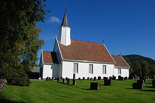
Jelsa is a former municipality in Rogaland county, Norway. The 130-square-kilometre (50 sq mi) municipality existed from 1838 until 1965. It encompassed area in the present-day municipalities of Suldal, Hjelmeland, and Finnøy that surround the Sandsfjorden. The administrative centre was the village of Jelsa, where Jelsa Church is located.

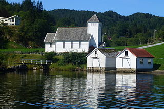
Sand is a former municipality in Rogaland county, Norway. The 221-square-kilometre (85 sq mi) municipality encompassed the area around the Hylsfjorden and the inner part of the Sandsfjorden. The administrative centre of the municipality was the village of Sand where Sand Church is located.
Marvik is a village in Suldal municipality in Rogaland county, Norway. The village is located along the Sandsfjorden on the southern coast of the Ropeid peninsula. The village is a commercial centre of the peninsula, having a general store, primary school, marina, library, and Marvik Chapel.
Imslandsjøen or Imsland is a village in Vindafjord municipality in Rogaland county, Norway. The village is located on the northern shore of the Vindafjorden, about 5 kilometres (3.1 mi) southeast of the village of Vikedal and about 12 kilometres (7.5 mi) west of the village of Sand in neighboring Suldal municipality. Imsland Church is located in the village.


