Grosses Fiescherhorn is a mountain peak of the Bernese Alps, located on the border between the cantons of Bern and ValaisValais, halfway between the Mönch and the Finsteraarhorn. At 4,049 metres (13,284 ft) above sea level, its summit culminates over the whole Fiescherhorn massif, which is also composed of the slightly lower Hinteres Fiescherhorn to the south and Kleines Fiescherhorn to the east. From the north both are well hidden behind other mountain peaks and can only been seen from Isch in Grindelwald. The mountain is shared between the municipalities of Grindelwald and Fieschertal.

The Dom is a mountain of the Pennine Alps, located between Randa and Saas-Fee in the canton of Valais. With its 4,545 m (14,911 ft) summit it is the third highest mountain in the Alps and the second highest in Switzerland, after Monte Rosa. The Dom is the main summit of the Mischabel group, which is the highest massif lying entirely in Switzerland.

The Allgäu Alps are a mountain range in the Northern Limestone Alps, located in Bavaria in Germany and Tyrol and Vorarlberg in Austria. The range lies directly east of Lake Constance.

The Gross Lohner, is a limestone mountain of the Bernese Alps, located between Adelboden and Kandersteg in the Bernese Oberland. The main summit has an elevation of 3,048.7 metres (10,002 ft) above sea level and is distinguished by the name Vorder Lohner. The mountain features several other peaks, from east to west:

The Wetterstein mountains, colloquially called Wetterstein, is a mountain group in the Northern Limestone Alps within the Eastern Alps. It is a comparatively compact range located between Garmisch-Partenkirchen, Mittenwald, Seefeld in Tirol and Ehrwald along the border between Germany (Bavaria) and Austria (Tyrol). Zugspitze, the highest peak is at the same time the highest mountain in Germany.

The Wetterspitzen are three of the rocky peaks on a mountain ridge in the Wetterstein mountains in the central part of the Eastern Alps in Germany. They lie two kilometres, as the crow flies, southwest of Germany's highest peak, the Zugspitze, on the border between the Austrian province of Tyrol and the German state of Bavaria. The Wetterspitzen form the southwest perimeter of the Zugspitze ledge (Zugspitzplatt); below and to the east is the ski region on the Schneeferner with its research station, the Schneefernerhaus.
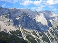
At 2,744 metres (9,003 ft), the Hochwanner is the second highest mountain in Germany after the Zugspitze. In addition the Hochwanner is the highest peak on the main ridge of the Wetterstein (Wettersteinhauptkamm) running from Gatterl to the Upper Wettersteinspitze above Mittenwald in an east-west direction. From the Hochwanner massif there is an all-round view of the Rein valley (Reintal), the Leutasch valley in Austria, the Gais valley, the Zugspitze, the Mieming Chain, the Jubiläumsgrat, the Karwendel mountains and far into the central Alps.

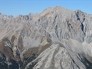
Dreitorspitze is a large and very prominent, multi-peak mountain massif in the eastern part of the Wetterstein Mountains in southern Germany. It is divided into Partenkirchen Dreitorspitze at 2,633 metres (8,638 ft) and Leutasch Dreitorspitze at 2,682 metres (8,799 ft); each of which has several peaks. The main peak of the fourth highest mountain massif in Germany is the Leutasch Dreitorspitze, which is also known as the Karlspitze. The Dreitorspitze marks the spot where the main chain of the Wetterstein mountains changes direction from its primary east-west orientation to run northwards for a short distance, before turning back again onto its main axis. East of the Dreitorspitze lies the karst plateau of the Leutasch Platt, comparable to the Zugspitzplatt at the foot of the Zugspitze.
The Hochblassen is a mountain 2,706 metres (8,878 ft) high, located in the Wetterstein in the German state of Bavaria. In addition to the main summit, it has a sub-peak, the so-called Signalgipfel which is 2,698 metres (8,852 ft) high. It was first climbed in 1871 by Hermann von Barth and Peter Klaisl.

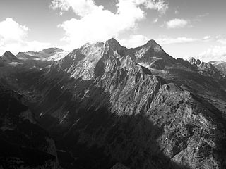
The Mädelegabel is a 2,645 metre high mountain, made of main dolomite, in the Allgäu Alps near Oberstdorf. It is one of the best-known and most-climbed high peaks in the German Alps, Within the Allgäu Alps it is the fourth-highest summit, with rock faces up to 400 metres high. Together with the Trettachspitze and the Hochfrottspitze it forms the famous triumvirate of peaks on the main crest of the Allgäu. Its name comes from Mähder - a mown mountain pasture in the vicinity - and gabel from the appearance of the triumvirate to the north which recalls a fork. Originally the Mädelegabel was the name for all three peaks of the triumvirate; only later were they distinguished from one another by name.

The Plattspitzen is a 2,680 metre high mountain in the Wetterstein Mountains on the border between Germany and Austria. It is a very striking mountain and the southern companion of Germany's highest peak, the Zugspitze, located at the opposite end of the ledge known as the Plattumrahmung. The mountain has three summits: the eastern summit, known as the Gatterlspitz, the middle summit and the western summit. It was first climbed in 1871 by Hermann von Barth, who conquered all three peaks alone departing from the Zugspitzplatt ledge. At that time the mountain was also known as the Wetterschrofen.

The Reintal is the name given to the upper and lower valleys of the River Partnach between the Zugspitzplatt plateau and the Partnachklamm gorge. A hiking route to Germany's highest mountain, the Zugspitze runs through the valley.

The Regalmspitze is a 2,253 metres (7,392 ft) high, lesser known mountain in the Kaisergebirge in the Northern Limestone Alps in Austria. The name Regalmwand, refers to the 2,227 metres (7,306 ft) high subpeak to the west of the Regalmspitze.

The Riffelwandspitzen are two adjacent mountains in the Wetterstein range in Bavaria. The summit of the Great Riffelwandspitze reaches a height of 2,626 m, the summit of the Little Riffelwandspitze2,543 m.

The Reintalanger Hut (1,366 m) is an Alpine Club hut in the Wetterstein Mountains at the head of the Reintal valley. The River Partnach has its source in the vicinity. West of the hut the valley floor climbs steeply up to the plateau of the Zugspitzplatt below Germany's highest mountain.

The Knorr Hut is a mountain hut belonging to the German Alpine Club and located in the Wetterstein Mountains at a height of 2,052 m. Its lies right on the edge of the Zugspitzplatt where it drops into the Reintalanger in a location with scenic views and is an important base for hikers who can climb up to it on the normal route from the town of Garmisch-Partenkirchen through the Reintal valley to Germany’s highest mountain, the Zugspitze.