The vast majority of passenger travel in the United States occurs by automobile for shorter distances and airplane or railroad for longer distances. Most cargo in the U.S. is transported by, in descending order, railroad, truck, pipeline, or boat; air shipping is typically used only for perishables and premium express shipments. Transportation is the largest source of greenhouse gas emissions in the United States.

An intelligent transportation system (ITS) is an advanced application that aims to provide innovative services relating to different modes of transport and traffic management and enable users to be better informed and make safer, more coordinated, and 'smarter' use of transport networks.

Traffic congestion is a condition in transport that is characterized by slower speeds, longer trip times, and increased vehicular queueing. Traffic congestion on urban road networks has increased substantially since the 1950s. When traffic demand is great enough that the interaction between vehicles slows the traffic stream, this results in congestion. While congestion is a possibility for any mode of transportation, this article will focus on automobile congestion on public roads.

Parking is the act of stopping and disengaging a vehicle and usually leaving it unoccupied. Parking on one or both sides of a road is often permitted, though sometimes with restrictions. Some buildings have parking facilities for use of the buildings' users. Countries and local governments have rules for design and use of parking spaces.

Electronic toll collection (ETC) is a wireless system to automatically collect the usage fee or toll charged to vehicles using toll roads, HOV lanes, toll bridges, and toll tunnels. It is a faster alternative which is replacing toll booths, where vehicles must stop and the driver manually pays the toll with cash or a card. In most systems, vehicles using the system are equipped with an automated radio transponder device. When the vehicle passes a roadside toll reader device, a radio signal from the reader triggers the transponder, which transmits back an identifying number which registers the vehicle's use of the road, and an electronic payment system charges the user the toll.

The Electronic Road Pricing (ERP) system is an electronic toll collection scheme adopted in Singapore to manage traffic by way of road pricing, and as a usage-based taxation mechanism to complement the purchase-based Certificate of Entitlement system. There are a total of 93 ERP gantries being built and located throughout the country, along expressways and roads leading towards the Central Area. As of July 2024, only 19 ERP gantries are in operation and are all in expressways where congestion continues to be severe.

Advanced driver-assistance systems (ADAS) are technologies that assist drivers with the safe operation of a vehicle. Through a human-machine interface, ADAS increase car and road safety. ADAS use automated technology, such as sensors and cameras, to detect nearby obstacles or driver errors, and respond accordingly. ADAS can enable various levels of autonomous driving.

Vehicular automation involves the use of mechatronics, artificial intelligence, and multi-agent systems to assist the operator of a vehicle such as a car, lorry, aircraft, or watercraft. A vehicle using automation for tasks such as navigation to ease but not replace human control, qualify as semi-autonomous, whereas a fully self-operated vehicle is termed autonomous.
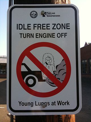
Idle reduction describes technologies and practices that minimize the amount of time drivers idle their engines. Avoiding idling time has a multitude of benefits including: savings in fuel and maintenance costs, extending vehicle life, and reducing damaging emissions. An idling engine consumes only enough power to keep itself and its accessories running, therefore, producing no usable power to the drive train.

A traffic collision, also known as a motor vehicle collision, or car crash, occurs when a vehicle collides with another vehicle, pedestrian, animal, road debris, or other moving or stationary obstruction, such as a tree, pole or building. Traffic collisions often result in injury, disability, death, and property damage as well as financial costs to both society and the individuals involved. Road transport is statistically the most dangerous situation people deal with on a daily basis, but casualty figures from such incidents attract less media attention than other, less frequent types of tragedy. The commonly used term car accident is increasingly falling out of favor with many government departments and organizations, with the Associated Press style guide recommending caution before using the term. Some collisions are intentional vehicle-ramming attacks, staged crashes, vehicular homicide or vehicular suicide.
San Francisco congestion pricing is a proposed traffic congestion user fee for vehicles traveling into the most congested areas of the city of San Francisco at certain periods of peak demand. The charge would be combined with other traffic reduction projects. The proposed congestion pricing charge is part of a mobility and pricing study being carried out by the San Francisco County Transportation Authority (SFCTA) to reduce congestion at and near central locations and to reduce its associated environmental impacts, including cutting greenhouse gas emissions. The funds raised through the charge will be used for public transit improvement projects, and for pedestrian and bike infrastructure and enhancements.

Internavi is a vehicle telematics service offered by the Honda Motor Company to drivers in Japan. In the United States, the service is known as HondaLink, or sometimes MyLink. It provides mobile connectivity for on-demand traffic information services and internet provided maps displayed inside selected Honda vehicles. The service began August 1997 and was first offered in the 1998 Honda Accord and the Honda Torneo sold only in Japan starting July 1998. The service received a revision to services offered October 2002, adding traffic information delivery capabilities for subscribers to the Internavi Premium Club, and was optional on most Honda vehicles sold in Japan. VICS was integrated into the service starting September 2003. Membership in the service has steadily grown to exceed 5 million subscribers as of March 2007.
Urban freight distribution is the system and process by which goods are collected, transported, and distributed within urban environments. The urban freight system can include seaports, airports, manufacturing facilities, and warehouse/distribution centers that are connected by a network of railroads, rail yards, pipelines, highways, and roadways that enable goods to get to their destinations.

A ridesharing company, ride-hailing service, is a company that, via websites and mobile apps, matches passengers with drivers of vehicles for hire that, unlike taxis, cannot legally be hailed from the street.

Iteris Inc. is an American company based in Austin, Texas that provides software, hardware and services for smart mobility infrastructure management, including software as a service, cloud-enabled managed services, consulting and advisory services, and sensors and other devices that record and predict traffic conditions. Iteris Inc. was established in 2004. The company from which it was formed, Odetics Inc., was originally founded in 1969, in Anaheim, California and incorporated in Delaware in 1987. Joe Bergera has served as the company's president and chief executive officer since 2015, and Iteris reported revenue of $156.1 million in fiscal year 2023, ending March 31.
Mobility as a service (MaaS) is a type of service that enables users to plan, book, and pay for multiple types of mobility services through a combined platform. Transportation services from public and private transportation providers are combined through a unified gateway, usually via an app or website, that creates and manages the trip and payments, including subscriptions, with a single account. The key concept behind MaaS is to offer travelers flexible mobility solutions based on their travel needs, thus "mobility as a service" also refers to the broader concept of a shift away from personally-owned modes of transportation and towards mobility provided as a service.

A scooter-sharing system is a shared transport service in which electric motorized scooters are made available to use for short-term rentals. E-scooters are typically "dockless", meaning that they do not have a fixed home location and are dropped off and picked up from certain locations in the service area.
The impact of self-driving cars is anticipated to be wide-ranging in many areas of daily life. Self-driving cars have been the subject of significant research on their environmental, practical, and lifestyle consequences and their impacts remain debated.

Nexar is a provider of the world's first open vehicle-to-vehicle (V2V) network for preventing road collisions and enabling autonomous mobility.

Virtual Singapore is a 3D digital model of Singapore that uses real-time and topographical data. It is a digital twin of the city-state, and the first digital twin of a country. Virtual Singapore is co-led by the National Research Foundation, the Singapore Land Authority (SLA) and the Government Technology Agency. The Government of Singapore used Dassault Systèmes' 3DEXPERIENCE City to create the digital model.