Transport in Antarctica has transformed from explorers crossing the isolated remote area of Antarctica by foot to a more open era due to human technologies enabling more convenient and faster transport, predominantly by air and water, but also by land as well. Transportation technologies on a remote area like Antarctica need to be able to deal with extremely low temperatures and continuous winds to ensure the travelers' safety. Due to the fragility of the Antarctic environment, only a limited amount of transport movements can take place and sustainable transportation technologies have to be used to reduce the ecological footprint. The infrastructure of land, water and air transport needs to be safe and sustainable. Currently thousands of tourists and hundreds of scientists a year depend on the Antarctic transportation system.

Mount Erebus is the second-highest volcano in Antarctica, the highest active volcano in Antarctica, and the southernmost active volcano on Earth. It is the sixth-highest highest point of an island, and the second most prominent mountain in Antarctica after Mount Vinson. It has a summit elevation of 3,794 metres (12,448 ft). It is located in the Ross Dependency on Ross Island, which is also home to three inactive volcanoes: Mount Terror, Mount Bird, and Mount Terra Nova. The mountain was named by Captain James Clark Ross in 1841 for his ship, the Erebus.
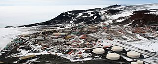
McMurdo Station is an American Antarctic research station on the southern tip of Ross Island, which is in the New Zealand–claimed Ross Dependency on the shore of McMurdo Sound in Antarctica. It is operated by the United States through the United States Antarctic Program (USAP), a branch of the National Science Foundation. The station is the largest community in Antarctica, capable of supporting up to 1,500 residents, and serves as one of three year-round United States Antarctic science facilities. All personnel and cargo going to or coming from Amundsen–Scott South Pole Station first pass through McMurdo. McMurdo Station continues to operate as the hub for American activities on the Antarctic continent. By road, McMurdo is 3 kilometres (1.9 mi) from New Zealand's smaller Scott Base.

Scott Base is a New Zealand Antarctic research station at Pram Point on Ross Island near Mount Erebus in New Zealand's Ross Dependency territorial claim. It was named in honour of Captain Robert Falcon Scott, RN, leader of two British expeditions to the Ross Sea area of Antarctica. The base was set up as support to field research and the centre for research into earth sciences, and now conducts research in many fields, operated by Antarctica New Zealand.

The McMurdo Dry Valleys are a row of largely snow-free valleys in Antarctica, located within Victoria Land west of McMurdo Sound. The Dry Valleys experience extremely low humidity and surrounding mountains prevent the flow of ice from nearby glaciers. The rocks here are granites and gneisses, and glacial tills dot this bedrock landscape, with loose gravel covering the ground. It is one of the driest places on Earth and is sometimes claimed to have not seen rain in nearly two million years, though this is highly unlikely and several anecdotal accounts of rainfall within the Dry Valleys exist.
The McMurdo Sound is a sound in Antarctica, known as the southernmost passable body of water in the world, located approximately 1,300 kilometres (810 mi) from the South Pole.

The United States Antarctic Program is an organization of the United States government which has a presence in the Antarctica continent. Founded in 1959, the USAP manages all U.S. scientific research and related logistics in Antarctica as well as aboard ships in the Southern Ocean.
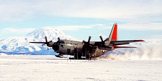
Williams Field or Willy Field is a United States Antarctic Program airfield in Antarctica. Williams Field consists of two snow runways located on approximately 8 meters (25 ft) of compacted snow, lying on top of 8–10 ft of ice, floating over 550 meters (1,800 ft) of water. The airport, which is approximately seven miles from Ross Island, serves McMurdo Station and New Zealand's Scott Base. Until the 2009–10 summer season, Williams was the major airfield for on-continent aircraft operations in Antarctica.
Observation Hill is a steep 754-foot (230 m) hill adjacent to McMurdo Station in Antarctica and commonly called "Ob Hill." It is frequently climbed to get good viewing points across the continent. Regular clear skies give excellent visibility.

Castle Rock is a bold rock crag, 415 metres (1,362 ft) high, standing 3 nautical miles northeast of Hut Point on the central ridge of Hut Point Peninsula, Ross Island, Antarctica. It was discovered by the British National Antarctic Expedition, 1901–04, under Robert Falcon Scott, who so named it because of its shape. The feature was a landmark for sledging parties returning from journeys to the south.

Marble Point is a rocky promontory on the coast of Victoria Land, Antarctica. The United States operates a station at the point. The outpost is used as a helicopter refueling station supporting scientific research in the nearby continental interior, such as the McMurdo Dry Valleys. Dependent upon the weather conditions at the time, helicopters are able to fly in and out of the station 24 hours a day during the summer research season.

An ice pier or ice wharf is a man-made structure used to assist the unloading of ships in Antarctica. It is constructed by pumping seawater into a contained area and allowing the water to freeze. By repeating this procedure several times, additional layers are built up. The final structure is many metres in thickness, and strong enough to support container trucks. Operation Deep Freeze personnel constructed the first floating ice pier at Antarctica’s southernmost sea port at McMurdo Station in 1973. Ice piers have been in use each summer season since, at McMurdo's natural harbor at Winter Quarters Bay located at 77°50′S166°40′E. The harbor is positioned on the southern tip of Ross Island.

Hut Point Peninsula is a long, narrow peninsula from 2 to 3 nautical miles wide and 15 nautical miles long, projecting south-west from the slopes of Mount Erebus on Ross Island, Antarctica. McMurdo Station (US) and Scott Base (NZ) are Antarctic research stations located on the Hut Point Peninsula.

Winter Quarters Bay is a small cove of McMurdo Sound, Antarctica, located 2,200 miles (3,500 km) due south of New Zealand at 77°50'S. The harbor is the southernmost port in the Southern Ocean and features a floating ice pier for summer cargo operations. The bay is approximately 250m wide and long, with a maximum depth of 33m. The name Winter Quarters Bay refers to Robert Falcon Scott's National Antarctic Discovery Expedition (1901–04) which wintered at the site for two seasons.
The Erebus Glacier Tongue is a mountain outlet glacier and the seaward extension of Erebus Glacier from Ross Island. It projects 11 kilometres (6.8 mi) into McMurdo Sound from the Ross Island coastline near Cape Evans, Antarctica. The glacier tongue varies in thickness from 50 metres (160 ft) at the snout to 300 metres (980 ft) at the point where it is grounded on the shoreline. Explorers from Robert F. Scott's Discovery Expedition (1901–1904) named and charted the glacier tongue.

The Chapel of the Snows is a non-denominational Christian church located at the United States' McMurdo Station on Ross Island, Antarctica and is one of eight churches on Antarctica.

The South Pole, also known as the Geographic South Pole or Terrestrial South Pole, is the southernmost point on Earth and lies antipodally on the opposite side of Earth from the North Pole, at a distance of 20,004 km in all directions. It is one of the two points where Earth's axis of rotation intersects its surface.
Wohlschlag Bay is a large bay indenting the western side of Ross Island, Antarctica, and lying between Harrison Bluff and Cape Royds.

Pegasus Road is an 18-mile (29 km) long road of dirt and packed snow constructed by the United States Antarctic Program on Ross Island and the Ross Ice Shelf in Antarctica. The trip along the road from McMurdo Station to Pegasus Field takes approximately 45 minutes in a "Delta" wheeled vehicle, although on occasion high temperatures have damaged the runway and caused the road surface to deteriorate enough to lengthen the trip to two hours.

Midwinter Day, or Midwinter, is an annual celebration held across Antarctica on the day of the southern winter solstice. It is the continent's primary cultural holiday and, along with Antarctica Day, is one of two principal Antarctic holidays. It is a celebration for personnel overwintering at Antarctic research stations, although some people off the continent observe it as well.
