| Ichhu Muruq'u | |
|---|---|
 Ichhu Muruq'u Peru | |
| Highest point | |
| Elevation | 4,600 m (15,100 ft) [1] |
| Coordinates | 14°28′10″S70°09′44″W / 14.46944°S 70.16222°W Coordinates: 14°28′10″S70°09′44″W / 14.46944°S 70.16222°W |
| Geography | |
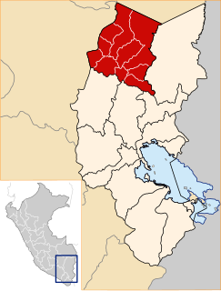
| Location | Peru, Puno Region |
| Parent range | Andes |
Ichhu Muruq'u (Quechua ichhu Peruvian feather grass (stipa ichu), muruq'u ball (of yarn, wool), [2] "ichhu ball", hispanicized spelling Ichumoroco) is a mountain in the Peruvian Andes, about 4,600 metres (15,092 ft) high. It is located in the Puno Region, Azángaro Province, on the border of the districts Potoni and San Antón. Ichhu Muruq'u lies west of the mountain Ch'iyar Jaqhi and northeast of Yuraq Apachita and Quri Kunka. [1]

Jarava ichu, commonly known as Peruvian feathergrass, ichhu, paja brava, and paja ichu, is a grass endemic to Guatemala, Mexico, Costa Rica, El Salvador, Venezuela, Bolivia, Colombia, Ecuador, Peru, Chile, and Argentina, growing extensively in the Andean altiplano. It is used as fodder for livestock, principally South American camelids like the llama.

Peru, officially the Republic of Peru, is a country in western South America. It is bordered in the north by Ecuador and Colombia, in the east by Brazil, in the southeast by Bolivia, in the south by Chile, and in the west by the Pacific Ocean. Peru is a megadiverse country with habitats ranging from the arid plains of the Pacific coastal region in the west to the peaks of the Andes mountains vertically extending from the north to the southeast of the country to the tropical Amazon Basin rainforest in the east with the Amazon river.

The Andes or Andean Mountains are the longest continental mountain range in the world, forming a continuous highland along the western edge of South America. This range is about 7,000 km (4,300 mi) long, about 200 to 700 km wide, and of an average height of about 4,000 m (13,000 ft). The Andes extend from north to south through seven South American countries: Venezuela, Colombia, Ecuador, Peru, Bolivia, Chile and Argentina.