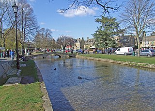
Bourton-on-the-Water is a village and civil parish in Gloucestershire, England, that lies on a wide flat vale within the Cotswolds Area of Outstanding Natural Beauty. The village had a population of 3,296 at the 2011 census. Much of the village centre is a designated Conservation Area.
Winstone is a village and civil parish in the English county of Gloucestershire. The population taken at the 2011 census was 270.

Hawkesbury is a hamlet and civil parish in South Gloucestershire, England. The hamlet, consisting of a few cottages around a triangular green, lies west of Hawkesbury Upton, off the A46 road.

Doynton is a village in South Gloucestershire, England. The population of this village taken at the 2011 census was 320.

Horton is a village and civil parish on the Cotswold Edge, in the South Gloucestershire district, in the ceremonial county of Gloucestershire, England. It is about 2+1⁄2 miles (4.0 km) north of Chipping Sodbury. The nearest settlement is Little Sodbury, about 1+1⁄2 miles (2.4 km) away; Hawkesbury Upton and Dunkirk are both 2+1⁄2 miles (4.0 km) miles away. It is a linear settlement built on the slopes of a steep hill. In 2011 the parish had a population of 355. On 1 April 2023 the parish of Little Sodbury was merged with Horton.

Quenington is a nucleated village and larger rural civil parish in the Cotswold district of Gloucestershire, England, on the River Coln 8 miles (13 km) east of Cirencester and 2 miles (3.2 km) north of Fairford. It had a recorded population of 603 at the 2011 census.
Ashley is a village and civil parish in the Cotswold district of Gloucestershire, England, about 8 miles south-west of Cirencester. According to the 2001 census it had a population of 142, decreasing to 131 at the 2011 census. To the north, across the A433 road, is Trull House.
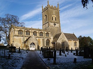
Dowdeswell is a civil parish in the ward of Chedworth, Cotswold, in the ceremonial county of Gloucestershire, England. It is separated into Upper and Lower Dowdeswell, the former being south of the latter. The population of the civil parish at the 2011 census was 134.

Baunton is a village and civil parish in the Cotswold district of Gloucestershire, England, located about two miles north of Cirencester on the River Churn.

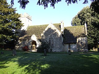
Beverston is a village and civil parish in the Cotswold district of Gloucestershire, England. According to the 2001 census it had a population of 132, decreasing to 129 at the 2011 census. The village is about two miles west of Tetbury. Beverston is an example of a typical unaltered Gloucestershire Cotswold village. It is home to Beverston Castle dating to the 12th Century, a Norman Church St Mary's Church, Beverston, and some examples of Cotswold architecture.

Dumbleton is a village and civil parish in the Tewkesbury district, in the county of Gloucestershire, England. The village is roughly 20 miles from the city of Gloucester. The village is known to have existed in the time of Æthelred I who granted land to Abingdon Abbey, and it is mentioned in the Domesday Book.

Hawling is a small village and civil parish in the Cotswolds of England, close to Bourton-on-the-Water and Guiting Power. The Church, the Elizabethan manor house and the Rectory form a group of listed buildings. The population taken at the 2011 census was 224. Cheltenham is about ten miles away.

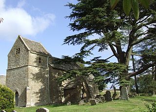
The twin villages of Shipton Oliffe and Shipton Solars are situated just 7 miles (11 km) from Cheltenham. The River Coln, just a small stream at this point, flows through the village over two fords and innumerable little water splashes, creating ornamental lakes in private properties. The population of the parish at the 2011 census was 365.
Withington is a Cotswold village and civil parish in Gloucestershire, England, about 7 miles (11 km) southeast of Cheltenham and 8 miles (13 km) north of Cirencester. The River Coln runs through the village. The parish includes the hamlets of Hilcot, Foxcote and Cassey Compton. The parish population taken at the 2011 census was 532.

Miserden is a village and civil parish in Stroud District, Gloucestershire, England, 4 miles north east of Stroud. The parish includes Whiteway Colony and the hamlets of Sudgrove and The Camp. In the 2001 census the parish had a population of 420, increasing to 449 at the 2011 census.

Coates is a village and civil parish situated in Cotswold District, Gloucestershire, England. It is around 3 miles (4.8 km) west of Cirencester and close to Cirencester Park, part of the Bathurst Estate. It is the nearest village to the source of the river Thames at Thames Head, and it is close to the course of the Foss Way or Fosse Way, the ancient Roman road. The nearest railway station is Kemble. The village population taken at the 2021 census was 491.

Edgeworth is a small village and civil parish in the English county of Gloucestershire. It is located east of Stroud, west of Cirencester and south of Cheltenham.

St Mary's Church is a redundant Anglican church in the village of Shipton Sollars, Gloucestershire, England under the care of The Churches Conservation Trust. It is recorded in the National Heritage List for England as a designated Grade I listed building,

Church of St Mary is a Grade I listed church in Linslade, Bedfordshire, England. It became a listed building on 20 February 1954.

The Anglican Church of St Mary at Icomb in the Cotswold District of Gloucestershire, England was built in the 15th century. It is a grade I listed building.

