The Continental Divide National Scenic Trail is a United States National Scenic Trail with a length measured by the Continental Divide Trail Coalition of 3,028 miles (4,873 km) between the U.S. border with Chihuahua, Mexico and the border with Alberta, Canada. Frequent route changes and a large number of alternate routes result in an actual hiking distance of 2,700 miles (4,300 km) to 3,150 miles (5,070 km). The CDT follows the Continental Divide of the Americas along the Rocky Mountains and traverses five U.S. states — Montana, Idaho, Wyoming, Colorado, and New Mexico. In Montana near the Canadian border the trail crosses Triple Divide Pass.

The Bitterroot Range is a mountain range and a subrange of the Rocky Mountains that runs along the border of Montana and Idaho in the northwestern United States. The range spans an area of 24,223 square miles (62,740 km2) and is named after the bitterroot, a small pink flower that is the state flower of Montana.

The Selway–Bitterroot Wilderness is a protected wilderness area in the states of Idaho and Montana, in the northwestern United States. At 1.3 million acres (5,300 km²), it is one of the largest designated wilderness areas in the United States.

The Gospel Hump Wilderness is a federally-protected wilderness area that covers 205,796 acres (83,283 ha) of the state of Idaho. Managed by the U.S. Forest Service in the U.S. Department of Agriculture, it received wilderness designation on February 24, 1978 through the passage of the Endangered American Wilderness Act and is part of Nez Perce National Forest. As part of the National Wilderness Preservation System, the Gospel Hump Wilderness is an area where human development and use are restricted and people are to remain only visitors.

Clearwater National Forest with headquarters on the Nez Perce Reservation at Kamiah is located in North Central Idaho in the northwestern United States. The forest is bounded on the east by the state of Montana, on the north by the Idaho Panhandle National Forest, and on the south and west by the Nez Perce National Forest and Palouse Prairie.
The Bitterroot Valley is located in southwestern Montana, along the Bitterroot River between the Bitterroot Range and Sapphire Mountains, in the Northwestern United States.

The Beaverhead–Deerlodge National Forest is the largest of the National Forests in Montana, United States. Covering 3.36 million acres (13,600 km2), the forest is broken into nine separate sections and stretches across eight counties in the southwestern area of the state. President Theodore Roosevelt named the two forests in 1908 and they were merged in 1996. Forest headquarters are located in Dillon, Montana. In Roosevelt's original legislation, the Deerlodge National Forest was called the Big Hole Forest Reserve. He created this reserve because the Anaconda Copper Mining Company, based in Butte, Montana, had begun to clearcut the upper Big Hole River watershed. The subsequent erosion, exacerbated by smoke pollution from the Anaconda smelter, was devastating the region. Ranchers and conservationists alike complained to Roosevelt, who made several trips to the area. (Munday 2001)

Bitterroot National Forest comprises 1.587 million acres (6,423 km2) in west-central Montana and eastern Idaho of the United States. It is located primarily in Ravalli County, Montana, but also has acreage in Idaho County, Idaho (29.24%), and Missoula County, Montana (0.49%).

Lolo National Forest is a national forest located in western Montana, United States with the western boundary being the state of Idaho. The forest spans 2 million acres (8,000 km2) and includes four wilderness areas; the Scapegoat and the Selway-Bitterroot Wilderness are partially within the forest while the Welcome Creek and Rattlesnake Wildernesses are solely in Lolo National Forest. The forest was created in 1906 from 4 different previous forests which were combined for administrative purposes. Lolo National Forest is west of the Continental divide and has a biodiversity influenced by both continental and maritime weather creating a transitional forest that has a high number of different plant and tree species.
Nez Perce Pass is a mountain pass in the Bitterroot Mountains on the border between the U.S. states of Idaho and Montana. The pass is at an elevation of 6,587 feet (2,008 m) above sea level. The Nez Perce Pass Trailhead offers access to the Selway-Bitterroot Wilderness and the Frank Church—River of No Return Wilderness.

The Lochsa River is in the northwestern United States, in the mountains of north central Idaho. It is one of two primary tributaries of the Middle Fork of the Clearwater River in the Clearwater National Forest. Lochsa is a Nez Perce word meaning rough water. The Salish name is Ep Smɫí, "It Has Salmon."

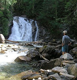
The Selway River is a large tributary of the Middle Fork of the Clearwater River in the U.S. state of Idaho. It flows within the Selway-Bitterroot Wilderness, the Bitterroot National Forest, and the Nez Perce National Forest of North Central Idaho. The entire length of the Selway was included by the United States Congress in 1968 as part of the National Wild and Scenic Rivers Act.
The Siskiyou Wilderness is a federal wilderness area designated by the passage of the California Wilderness Act of 1984. Originally, the land area was 153,000 acres (620 km2) The Northern California Wild Heritage Act of 2006 added 30,122 acres (121.90 km2) for the current total of 182,802 acres (739.77 km2). All of the wilderness is in Northern California and is managed by the U.S. Forest Service. The wilderness spans three national forests: the Rogue River–Siskiyou, the Klamath, and the Six Rivers.

Interstate 90 (I-90) is a transcontinental Interstate Highway that runs east–west across the northern United States. Within the state of Idaho, the freeway travels for 74 miles (119 km) from the Washington border near Spokane to Coeur d'Alene and the panhandle region at the north end of the state. After traveling through the Silver Valley along the Coeur d'Alene River in the Bitterroot Range, I-90 crosses into Montana at Lookout Pass.

U.S. Route 93 is a north–south U.S. Highway in the U.S. state of Idaho.

The Clearwater River is in the northwestern United States, in north central Idaho. Its length is 74.8 miles (120.4 km), it flows westward from the Bitterroot Mountains along the Idaho-Montana border, and joins the Snake River at Lewiston. In October 1805, the Lewis and Clark Expedition descended the Clearwater River in dugout canoes, putting in at "Canoe Camp," five miles (8 km) downstream from Orofino; they reached the Columbia Bar and the Pacific Ocean about six weeks later.

The Idaho Batholith ecoregion is a Level III ecoregion designated by the United States Environmental Protection Agency (EPA) in the U.S. states of Idaho and Montana. It is contained within the following biomes designated by the World Wild Fund for Nature (WWF): temperate coniferous forests; temperate grasslands, savannas, and shrublands; and deserts and xeric shrublands.
Syringa is an unincorporated community in the northwest United States in Idaho County, Idaho. Named for the shrub which grows in the area [Philadelphus lewisii], the state flower, it is in the Pacific Time Zone (UTC-8). At low elevation, the climate is mild, with an average annual precipitation exceeding 25 inches (65 cm).
The Salmon Mountain Lookout, on Salmon Mountain in the West Fork District of Bitterroot National Forest, near Darby, Idaho, was built in 1949. It was listed on the National Register of Historic Places in 2018.