Related Research Articles

Lagos State is a state in southwestern Nigeria. Of the 36 states, it is both the most populous and smallest in area. Bounded to the south by the Bight of Benin and to the west by the international border with Benin, Lagos State borders Ogun State to the northeast making it the only Nigerian state to border only one other state. Named for the city of Lagos—the most populous city in Africa—the state was formed from the Western Region and the former Federal Capital Territory on 27 May 1967.
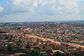
Ota is a town in Ogun State, Nigeria with an estimated 163,783 residents. Ota is the capital of the Ado-Odo/Ota Local Government Area. The traditional leader of Ota is the Olota of Ota, Oba Adeyemi AbdulKabir Obalanlege. Historically, Ota is the capital of the Awori Yoruba tribe.

Victoria Island (VI) is an affluent area that encompasses a former island of the same name neighbouring Lagos Island, Ikoyi and the Lekki Peninsula by the Lagos Lagoon. It is the main business and financial centre of Lagos State, Nigeria. Victoria Island is one of the most exclusive and expensive areas to reside in Lagos. The town and island lie within the boundaries of the Eti-Osa Local Government Area (LGA).
Ogun State is a state in southwestern Nigeria. Created on 3 February 1976 from the former Western State. Ogun State borders Lagos State to the south, Oyo State and Osun State to the north, Ondo State to the east, and the Republic of Benin to the west. Abeokuta is both Ogun State's capital and most populous city; other important cities in the state include Ijebu Ode, the royal capital of the Ijebu Kingdom, and Sagamu, Nigeria's leading kola nut grower. Ogun state is covered predominantly by rain forest and has wooden savanna in the northwest. Ogun State had a total population of 3,751,140 residents as of 2006, making Ogun State the 16th most populated state in Nigeria In terms of landmass, Ogun State is the 24th largest State in Nigeria with land area of 16,762 kilometer square.
The Itsekiri are one of the Yoruboid subgroup of Nigeria's Niger Delta area, Delta State. The Itsekiris presently number 2.7 million people and live mainly in the Warri South, Warri North and Warri South West local government districts of Delta State on the Atlantic coast of Nigeria. Significant communities of Itsekiris can be found in parts of Edo and Ondo states and in various other Nigerian cities including Lagos, Benin City, Port Harcourt and Abuja. Many people of Itsekiri descent also reside in the United Kingdom, the United States and Canada. The Itsekiris are closely related to the Yoruba of South Western Nigeria and also close to the Okpe people and Edo peoples. The Itsekiris traditionally refer to their land as the Kingdom of Warri or 'Iwere' as its proper name – which is geographically contiguous to the area covered by the three Warri local government districts. The area is a key centre of Nigeria's crude oil and natural gas production and petroleum refining and the main town Warri forms the industrial and commercial nucleus of the Delta State region.

The Ẹgbado, now Yewa, are a subgroup of the Yoruba people and inhabit the eastern area of Ogun West Senatorial District, Ogun State, in south-west Nigeria, Africa. In 1995 they changed their name to the Yewa which comes from the Yewa River which in turn comes from the Yoruba goddess Yewa. Your clan now comprises 4 local Governments Yewa South, Yewa North, Imeko-Afon, and Ipokia, while the Ado-Odo/Ota LGA forms the 5th Awori part of the senatorial district.

Lagos is the largest and former capital city of Nigeria and the largest city in Africa in terms of population with about 15.3 million people living in it. It is also the 4th largest economy in Africa.
Za-Kpota or Zakpota is a town, arrondissement, and commune in the Zou Department of south-western Benin. It is located 153 kilometres north of Cotonou and 33 kilometres east of Abomey.
Seme Border is a settlement in Nigeria on the border with Benin, thirty minutes drive from Badagry on the coastal road between Lagos and Cotonou. Seme is a part of Badagry Division of Lagos State. With the present political division in the state, it is under Badagry -West Local council development area (LCDA).
Ipokia is the metropolitan headquarters of Anago kingdom. It is an ancient kingdom in old Oyo empire. Unlike the other kingdoms, which had at one time or the other engaged in the internecine wars that ravaged Yorubaland in the nineteenth century, Ipokia stood out as an unconquered sanctuary city-state throughout the period. The year it was founded was not known but can be traced to 13th to 14th century when some prince and princess of Oramiyan, the 6th Ooni of ife and founder of Oyo and Benni kingdom migrate from Oyo ile and settled in Ajase ipo in present-day kwara state due to a little misunderstanding among the prince,then move downward toward west,Lagos with the ancient crown gotten from their forefathers, Oduduwa. settled briefly in Lagos shores,Badagry axis before finally settled down and formed a small town named Ipokia meaning( people from opo town) with the help and guidance of Ifa Oracle. Ipokia came to be a Local Government in 1996 carved from formally known as"Egbado south local government"but now "Yewa South local government in the west of Ogun State, Nigeria bordering the Republic of Benin. Its Capital is in Ipokia town. It is an exit route from Nigeria to outside world through road and water. It is also regarded as main gate to the gateway state due to its proximity and the boundary between Nigeria and Bennie republic. There are other towns like Idiroko, Oniro, Ita Egbe,Hunbo, Agosasa, Aseko, Maun, Koko, Ropo, Alaari, Tube, Ilashe, Ifonyintedo, Madoga, Ijofin and Tongeji Island in the town of Ipokia at6°32′00″N2°51′00″E.

Badagry also spelled Badagri, is a coastal town and Local Government Area (LGA) in Lagos State, Nigeria. It is quite close to the city of Lagos, and located on the north bank of Porto Novo Creek, an inland waterway that connects Lagos to the Beninese capital of Porto-Novo. The same route connects Lagos, Ilaro, and Porto-Novo, and shares a border with the Republic of Benin. As of the preliminary 2006 census results, the municipality had a population of 241,093.
The Karu Urban Area is an urban area in central Nigeria. The urban area is majorly located in the Nigerian state of Nasarawa, but with some parts stretching into the boundaries of the Federal Capital Territory (FCT). It has an area of 40,000 hectares (400 km2) and a population of some 2 million.

Lagos Colony was a British colonial possession centred on the port of Lagos in what is now southern Nigeria. Lagos was annexed on 6 August 1861 under the threat of force by Commander Beddingfield of HMS Prometheus who was accompanied by the Acting British Consul, William McCoskry. Oba Dosunmu of Lagos resisted the cession for 11 days while facing the threat of violence on Lagos and its people, but capitulated and signed the Lagos Treaty of Cession. Lagos was declared a colony on 5 March 1862. By 1872, Lagos was a cosmopolitan trading center with a population over 60,000. In the aftermath of prolonged wars between the mainland Yoruba states, the colony established a protectorate over most of Yorubaland between 1890 and 1897. The protectorate was incorporated into the new Southern Nigeria Protectorate in February 1906, and Lagos became the capital of the Protectorate of Nigeria in January 1914. Since then, Lagos has grown to become the largest city in West Africa, with an estimated metropolitan population of over 9,000,000 as of 2011.
Ifonyintedo is a town located in Ipokia Local Government Area of Ogun State in the South-western part of Nigeria. Founded in 1935, the town has grown to an estimated population of 10,000. It is primarily a farming community; however, commercial activities have increased recently owing to its proximity to the border with Republic of Benin. The people are predominantly Yoruba who speak the Anago dialect.
Brazilians in Nigeria, Amaros or Agudas consist of the descendants of freed Afro-Brazilian slaves who left Brazil and settled in Nigeria. The term Brazilians in Nigeria can also otherwise refer to first generation expatriates from Brazil.
Atan Ota is a frontline town located in the Ado-Odo/Ota Local Government Area which is one of the 19 Local Government Areas of Ogun State in southwest Nigeria. It is situated at 6°46'0"N 2°47'60"E and is 575 kilometres (357 mi) west of Abuja and 62 km (39 mi) northeast of Cotonou. The town is brimming with some 300,000 residents. It lies right on the international route linking Nigeria with the Republic of Benin and directly west of Sango Otta township. A hub of business activities. Most of the residents are traders who sell foodstuff, provision, poultry food. The population of the settlement keeps increasing constantly as more and more people move out from Lagos to build residential blocks in the booming suburb.

Abeni is a two-part 2006 Nigerian-Beninese romance film produced and directed by Tunde Kelani. It depicts the social divide that occurs as a result of colonialism despite the geographical proximity between Benin and Nigeria.
Iwoye-Ketu is a town primarily located in Imeko Afon, Ogun State in southwest Nigeria with its western portion in Benin. The community shares a border with the Iwajowa local government area of Oyo State on the north. It is renowned for its production of cotton.

The Gun people, also rendered Ogũ, Ogun and Egun, are an ethnic group located majorly in Lagos and Ogun State in southwestern Nigeria, and Ouémé Department in the southeast of the Republic of Benin, who speak the Gun language. The Ogu account for about 15% of the indigenous population of Lagos State and 6% of the total population of the Republic of Benin.
Ita Egbe is a village located in Ipokia Local Government Area of Ogun State with the population of 1776 as of 1963 according to the Nigeria Population Census, it is noted for its extensive agricultural activities around the area and by being one of the largest palm oil producers in Ipokia Local Government of Ogun state.
References
- ↑ Nigeria and Dahomey sign pact for a free exchange of goods. (1962, Jul 20). New York Times
- 1 2 3 4 5 Omoniyi 2004, p. 40.
- ↑ "Idiroko: One border, many exits - Vanguard News". 2 September 2012.
- ↑ Omoniyi 2004, p. 44.
- ↑ Omoniyi 2004, p. 48.
- ↑ Afolayan 2000.
- ↑ Tunde 2011.
- ↑ Terkula 2016.
- ↑ Omoniyi 2004, p. 42.