
Nigeria, officially the Federal Republic of Nigeria, is a country in West Africa. It is situated between the Sahel to the north and the Gulf of Guinea to the south in the Atlantic Ocean. It covers an area of 923,769 square kilometres (356,669 sq mi). With a population of more than 230 million, it is the most populous country in Africa, and the world's sixth-most populous country. Nigeria borders Niger in the north, Chad in the northeast, Cameroon in the east, and Benin in the west. Nigeria is a federal republic comprising 36 states and the Federal Capital Territory, where its capital, Abuja, is located. The largest city in Nigeria is Lagos, one of the largest metropolitan areas in the world and the largest in Africa.

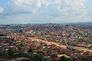
Kogi State is a state in the North Central region of Nigeria, bordered to the west by the states of Ekiti and Kwara, to the north by the Federal Capital Territory, to the northeast by Nasarawa State, to the northwest by Niger State, to the southwest by the Edo and Ondo states, to the southeast by the states of Anambra and Enugu, and to the east by Benue State. It is the only state in Nigeria to border ten other states. Named after the Hausa word for river (Kogi). Kogi State was formed from parts of Benue State, Niger State, and Kwara State on 27 August 1991. The state is nicknamed the "Confluence State" due to the fact that the confluence of the River Niger and the River Benue occurs next to its capital, Lokoja.
Ogun State is a state in southwestern Nigeria. As a Nigerian state, Ogun is the second most industrialised state after Lagos, with a focus on metal processing. It has good road and rail connections to the harbours in Lagos and Lekki. Wole Soyinka, winner of the Nobel Prize for Literature 1986, lives in Ogun.

Gbenga Daniel is a Nigerian politician who served as Senator for Ogun East since 2023. He previously served as governor of Ogun State from 2003 to 2011.

Agriculture is a major sector of the Nigerian economy, accounting for up to 35% of total employment in 2020. According to the FAO, agriculture remains the foundation of the Nigerian economy, providing livelihood for most Nigerians and generating millions of jobs. Along with crude oil, Nigeria relies on the agricultural products it exports to generate most of its national revenue. The agricultural sector in Nigeria comprises four sub-sectors: crop production, livestock, forestry, and fishing.

Kosofe is a Local Government Area of Lagos State, Nigeria and was created on the 27th day of November 1996. Its headquarters is in the town of Kosofe and is home to several neighborhoods, including Ketu, Oworonshoki, Agboyi-Ketu, Alapere, Mile 12, and Isheri Olowora. Other notable areas include Ifako/Soluyi, Ajao Estate, Mende, Maryland, Ojota, Ogudu, Agidi, Orisigun, Kosofe, Ajelogo, Akanimodo, Ikosi-Ketu, Agiliti, Maidan, Isheri-Olowo Ira, Shangisha, Magodo, Agboyi, Owode Onirin, and Odo-Ogun.

Benin is predominantly a rural society, and agriculture in Benin supports more than 70% of the population. Agriculture contributes around 35% of the country's gross domestic product (GDP) and 80% of export income. While the Government of Benin (GOB) aims to diversify its agricultural production, Benin remains underdeveloped, and its economy is underpinned by subsistence agriculture. Approximately 93% of total agricultural production goes into food production. The proportion of the population living in poverty is about 35.2%, with more rural households in poverty (38.4%) than urban households (29.8%). 36% of households depend solely upon agricultural (crop) production for income, and another 30% depend on crop production, livestock, or fishing for income.

Nkwerre is one of the Local Government Areas in Imo State, South-East, Nigeria. It is situated in Nkwerre town where the name of the local government area was derived. Its population was placed at 80,270 from the 2006 population census with an area of 38.447 km. It is known for its thick vegetation which is supposed to prevent soil erosion however, it is erosion prone area.
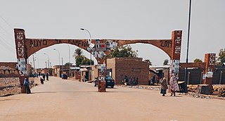
Auyo is a Local Government Area of Jigawa State, Nigeria. Its headquarters are in the town of Auyo.
Yewa North is a Local Government Area in the west of Ogun State, Nigeria bordering the Republic of Benin. Its headquarters are in the town of Aiyetoro at7°14′00″N3°02′00″E in the north-east of the Area.
Ipokia is the metropolitan headquarters of Anago kingdom. It is an ancient kingdom in old Oyo empire. Unlike the other kingdoms, which had at one time or the other engaged in the internecine wars that ravaged Yorubaland in the nineteenth century, Ipokia stood out as an unconquered sanctuary city-state throughout the period. The year it was founded was not known but can be traced to 13th to 14th century when some prince and princess of Oramiyan, the 6th Ooni of ife and founder of Oyo and Benni kingdom migrate from Oyo ile and settled in Ajase ipo in present-day kwara state due to a little misunderstanding among the prince, then move downward toward west,Lagos with the ancient crown gotten from their forefathers, Oduduwa. settled briefly in Lagos shores, Isale Eko before coming to Badagry axis and finally settled down and formed a small town named Ipokia meaning with the help and guidance of Ifa Oracle. Ipokia came to be a Local Government in 1996 carved from formally known as"Egbado south local government"but now "Yewa South local government in the west of Ogun State, Nigeria bordering the Republic of Benin. Its Capital is in Ipokia town. It is an exit route from Nigeria to outside world through road and water. It is also regarded as main gate to the gateway state due to its proximity and the boundary between Nigeria and Benin Republic. There are other towns like Idiroko, Oniro, Ita Egbe, Aretedo, Hunbo, Agosasa, Aseko, Maun, Koko, Ropo, Alaari, Tube, Ilashe, Ifonyintedo, Madoga, Idosemo, Ijofin and Tongeji Island in the town of Ipokia at 6°32′00″N2°51′00″E.

Obafemi Owode is a Local Government Area in Ogun State, Nigeria. Its headquarters are in the town of Owode at 6°57′N3°30′E.
Odigbo is a Local Government Area in Ondo State, Nigeria. Its headquarters are in the town of Ore.

Ìlàje is a Local Government Area in Ondo State, South-West Nigeria. Its headquarters are in the town of Igbokoda. The Ilajes are a distinct migratory coastal linguistic group of Yoruba peoples spread along the coastal belts of Ondo, Ogun, Lagos and Delta states and originally made up of four geo-political entities, namely: Ode Ugbo, Ode Mahin, Ode Etikan and Aheri. While most towns and villages in the Mahin kingdom are distributed on arable lands, the towns and villages in the other three polities of Ugbo, Aheri and Etikan kingdoms are spread out along the beaches and swampy terrain of the Atlantic Ocean coast.
Ido is a Local Government Area in Oyo State, Nigeria. Its headquarters are in the town of Ido.
Ibarapa East is a Local Government Area in Oyo State, Nigeria, made up of the Ibarapa people. Its headquarters are in the town of Eruwa.
Aiyekire is a Local Government Area of Ekiti State, Nigeria.
Idiroko is a town in Ipokia local government of Ogun State, Nigeria. It is situated along the Nigeria-Benin border and has been an official border crossing point since at least the 1960s. The town is surrounded by many other towns and villages including Oniro, Oke Odan, Ilase, Ita Egbe, Ajilete amongst others.

Ofada rice is a Yoruba dish. It is the name of an indigenous rice from a small community called Ofada, located in the Obafemi Owode Local Government Area of Ogun State. It is not exclusively grown in the community, but it is an indigenous rice grown in southwest Nigeria but named after the Ofada community. It is used in making a variety of dishes. Ofada rice are mostly blends, and some of the rice varieties in the blends are not indigenous to Africa; however, they usually also contain African rice. It is grown almost exclusively in Ogun State, a state in southwestern Nigeria. Ofada rice is grown on free-draining soil where the water table is permanently below the root of the plant.
